The official blog for Google Maps
A Big Thank You to our Growing Community of Bike Map Contributors
August 18, 2010
When we added U.S. biking directions to Google Maps
back in March
, we were eager to see the response from the cycling community. Through our partnership with the Rails-to-Trails Conservancy, we had detailed bike lane and trail information for 150 cities; and for the rest of the country, we recommended routes based on other data such as the size of the road, speed of traffic and hill steepness. On one hand, it would’ve been ideal for our directions feature to know about all the bike lanes and trails in the country. But on the other hand, we were aware that biking directions were one of our most-requested features and we wanted to provide information for bicycling fans as soon as possible.
So rather than wait, we decided to launch biking directions in “beta” and ask our community of bicycle-bound users for their help improving our bike maps. Through our “
Report a problem
” tool, any user can send us corrections or recommend improvements, and receive notifications from Google when their report has been resolved. We always knew the cycling community would be a passionate bunch, but the response to both our biking directions feature and our call to join in the effort to improve our bike maps has surpassed our happiest expectations.
More than 10,000 people have submitted about 25,000 suggestions for improvements to our bike maps. With their help, we’ve added bike lane and trail data for an additional 80 cities since our initial launch. This is an exciting and humbling response from the Google Maps community. It’s like having 10,000 new members of our bike maps team, contributing their time and energy to make Google Maps more useful for everyone.
These contributors have impacted biking directions across the nation - in small and large ways. Here are some examples of suggestions we’ve received:
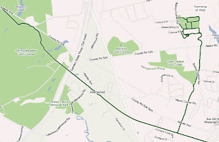
One user simply pointed out to us,
“Wall Township Bike path - http://www.wallrec.com/bicycling.htm.”
Our response to that short and sweet message?
Here it is
:
Some else sent a note saying,
“CSUS - there has been a bike/foot traffic tunnel that connects elvas ave to College town dr for about 6 years. it is located between 64 & 65 st.”
Well, that’s handy to know!
Done
:
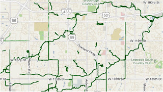
And yet another user shared,
“Cycle/hiking path continues to the East across Switzer and connects with the path that is currently shown on google maps ~2.5 miles to the ENE at 130th and Metcalf Ave. Details on Overland Park website http://www.opkansas.org/Resource_/PageResource/Maps-And-Stats/Maps/Adobe-Acrobat-PDF-Maps/bike_route_plan.pdf Thanks.”
Awesome! Overland Park is now
looking pretty good
for cyclists:
This is how we’ll build a great cycling map: Bit by bit, getting better with every tip and suggestion that users share about the lanes and trails they’ve ridden.
We want to say “Thank you!” to all those who’ve answered our call for bike map contributions. Clearly our users are passionate about helping to make our maps better, so we’re working hard to make the improvement process even easier and to speed up the processing time for user contributions.
In the meantime, happy biking! Just remember that our biking directions are still in beta, and to always use your judgement - don’t ride down any road that makes you uncomfortable. And if we’ve recommended a road that shouldn’t be used by the average bicyclist,
let us know
!
Posted by Dave Barth, Product Manager
Making our new building home
August 16, 2010
This past June, our Geo team finally outgrew our space, so it was time to move to a larger building on campus. To make sure our new building really felt like a home away from home, some of us got involved in the design planning and made it our mission to surprise everyone with a unique, inviting and very Googley new place to work.
We gave the new building a quintessentially Geo feel by putting
map-themed artwork
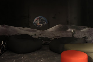
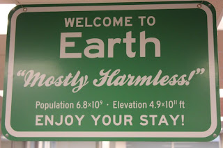
in the lobby and halls. We also decided to make quirky, fun places like the “Moon room,” complete with the Earth rising on the wall, moon rocks to nap on, crater-laden carpet and twinkling stars above.
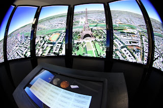
Then we added a
Liquid Galaxy
for Googlers and visitors to explore Google Earth on eight stunning LCD panels. Given that it’s right next to the café, we recommend that you use the Liquid Galaxy before eating, because swooping and zooming around in Google Earth in an immersive panorama can get a little intense.
Despite all of these geographic references, we heard that the new building’s layout had everyone confused! After plastering the walls with building floor plans and “You are here” stickers, we decided on two more creative solutions. First, we designed two “hiking trail” style sign posts for each floor so that folks could quickly find meeting rooms, which we named after famous explorers!
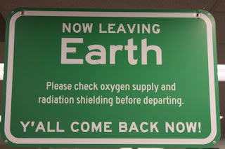
Second, we devised a contest for teams to design “road signs” to hang above their cubes, notifying visitors and lost team members where to find them. Teams had a couple weeks to craft and submit their design for a little friendly competition. While all the signs were being printed and hung, we encouraged everyone in the building to vote for their favorite signs. My personal favorite is the double-sided one created by the Google Earth team.
Photos courtesy of Brian Kiley.
Now, after seeing all the fun signs hanging throughout the building, teams that didn’t participate in the contest are rallying for a second round of sign design. All in all, the dust has settled, and everyone seems quite happy with our new digs.
Posted by Tai Kuncio, Administrative Assistant
Google Earth Enterprise 4.0 now available
August 13, 2010
[Cross-posted from the
Google Enterprise Blog
]
The Google Earth Enterprise team has long focused on bringing the innovative features of Google Earth and Maps to businesses, enabling them to create their own mapping applications from their existing data archives. Over the years we’ve released new features that have expanded the options for rapid, secure dissemination of geospatial data with
Google Earth Enterprise
(GEE), and with today’s release of GEE 4.0, we’re happy to announce support for two more important capabilities: mobile-based access to GEE systems, and
Google Earth Enterprise Portable Solution
. We’re also excited to let you know about the latest versions of the Google Earth Enterprise Client and Plug-in.
Mobile Access to your Globes
In February we released a native
Google Earth client for Android
to the Android Market. With GEE 4.0, the Android Google Earth client has been updated to support direct connections to customers’ globes, which permits their end-users to view their organization’s 3D globe, including all imagery, terrain, and vector layers, with support for custom vector search.
Google Earth Enterprise Un-Plugged
Some of you might have heard during a recent
Directions Media Webinar
that many of our GEE customers need to provide their end users with access to geospatial data for situational awareness, even when those users are in environments with limited or no Internet connectivity. To support this, GEE 4.0 introduces a new feature that permits authenticated end users to extract portions of a published GEE globe -- including all imagery, terrain, vectors, KMLs, and search -- and serve the data locally from their own laptops or other storage devices using a native, cross-platform, light-weight Portable Earth System.
Check out this video to see how the portable capability works.
Google Earth Enterprise Client 5.2
GEE 4.0 also has full support for the new
Google Earth 5.2 client
, with its many great new features, such as elevation profiles, native MGRS support, client-side data regionation, and the new embedded web-browser.
Google Earth Plug-in Updates
In addition to performance improvements, the latest release of the Google Earth Plugin includes support for historical imagery databases and the ability to connect to multiple globes simultaneously.
Existing customers can find GEE 4.0 upgrade information by logging into the Google Enterprise Support Portal.
Posted by Posted by Dylan Lorimer, Google Earth and Maps Product Manager
Beachcombing for New Imagery
August 12, 2010
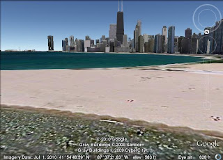
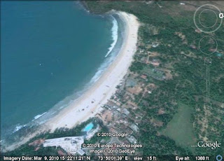
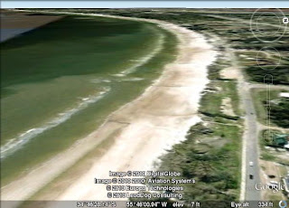
If you're anything like me, you can't get enough of beaches during the summer months. There are few activities as relaxing as sitting by the water, reading a book, and enjoying a cool beverage. This week's imagery update includes a number of great beaches, so if you live nearby, you may want to go soak up some sun. Just remember to bring your sunscreen!
Chicago, Illinois beach
Goa, India beach
Atlantida, Uruguay beach
Of course, it's only summer in the Northern Hemisphere, so be sure to put Uruguay on your list for future travel rather than flying over there now!
High Resolution Aerial Updates:
USA: Chicago, Stockton, Modesto, Nez Perce (ID), Barre (VT), Orange County (NC), Polk County (FL), Hardee County (FL), Okeechobee County (FL)
Uruguay: Salinas, Atlantida
Countries receiving High Resolution Satellite Updates:
Mexico, Guatemala, Nicaragua, Colombia, Venezuela, Brazil, Peru, Paraguay, Argentina, Chile, Morocco, Libya, Egypt, Senegal, The Gambia, Guinea, Ghana, Burkina Faso, Nigeria, Cameroon, Chad, Sudan, Ethiopia, Djibouti, Kenya, Uganda, Congo, The Democratic Republic of the Congo, Angola, Zambia, Mozambique, Zimbabwe, Botswana, South Africa, Madagascar, Jordan, Syria, Turkey, Russia, Iran, Pakistan, India, Sri Lanka, Bangladesh, China, Myanmar, Thailand, Vietnam, Japan, The Philippines, Indonesia, Australia, New Zealand
Countries receiving Medium Resolution Satellite Updates:
Canada, Guatemala, Belize, Honduras, Nicaragua, Benin, Togo, Ghana, Uganda, Kenya
Right now these updates are only available in Google Earth, but will be in Google Maps soon. For a complete picture of where we updated imagery, download
this KML
for viewing in
Google Earth
.
Posted by Matt Manolides, Senior Geo Data Strategist
Seeking map data in response to Pakistan floods
August 6, 2010
According to the UN, the
recent floods in Pakistan
have affected over 4 million individuals - and the human toll continues to grow. Disease is an ever-increasing risk as relief agencies rush to the aid of those who have been hurt or displaced.
Google’s Crisis Response team has provided satellite imagery and
KML layers
to assist relief efforts in past disasters, including the
Haiti earthquake
and recent
Gulf of Mexico oil spill
. In Pakistan, however, the cloud cover over the impacted areas has inhibited our ability to make this valuable content available. The Crisis Response team is looking to collect and aggregate imagery and user generated KML, or other map data, with the goal of making this content more accessible to both crisis responders and the general public. We’re hoping you can help. You can submit links to KML and map data via the following
form
. We’ll contact you if we are able to publish your content.
Loading...
View
BKTEF Relief Activity
in a larger map
Further, we’ve released a version of our
Person Finder tool
in Urdu. We realize many of the victims of this disaster lack any connectivity to the Internet, but remain hopeful that tools like this can assist the diaspora and general disaster community in collecting and dispersing information on the well-being of those impacted.
Your data might help relief efforts; we appreciate you sharing it with the world.
Posted by Steve Hakusa, Software Engineer, Google Crisis Response Team
Introducing the Google Small Business Blog
August 5, 2010
Most every business, including ours,
starts small
. These days, technology is giving businesses even more ways to grow bigger... faster.
In our recent
Small Business series
on the Official Google Blog, a handful of real-life entrepreneurs have shared their experiences building companies from scratch and embracing Internet tools that have taken their businesses to the next level. We’ve received fantastic feedback about these posts, and realized that there’s a healthy appetite among small- and medium-sized business owners who want to know all about the latest web tools and tricks. Fortunately, we have lots more to share with you, too!
That’s why we’re introducing the
Google Small Business Blog
, a central hub that brings together all the information about our products, features and projects of specific interest to the small business community. Rather than having to sleuth around in many different locations for details about
templates for creating video ads on YouTube
,
tips for your employees using Gmail
or
how to respond to the business reviews on your Place Page
, you can find all of this helpful information right here in one place.
Of course, we’ll continue to post relevant news about individual services such as
AdWords
,
Apps
,
Google Places
and
YouTube
on their respective
“home” blogs
, but feel free to visit or subscribe to the
Google Small Business Blog
to get everything relating to your small business needs. We’re starting small today, but who knows what tomorrow will have in store!
Posted by Deanna Yick, Small Business Blog Team
Respond to reviews for your business on Google Place Page
August 4, 2010
Whether you’re looking for a great lounge to hang out with your friends or a trusty shop to repair your bicycle, the web is a great place to discover and learn about local businesses and services. Some of the listings on
Google Maps
showcase reviews to help prospective customers make informed decisions and find the places that are just right for them. Reviews on Google Maps are assembled from a variety of sources on the web to give you the best possible overview of what people are saying about a specific place. We also encourage users to share their opinions by writing reviews directly on the
Place Page
of any place they’ve visited, be it a local business, tourist attraction or the like.
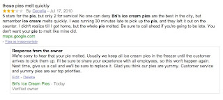
Starting today, if you’re a verified
Google Places
business owner, you can publicly respond to reviews written by Google Maps users on the Place Page for your business. Engaging with the people who have shared their thoughts about your business is a great way to get to know your customers and find out more. Both positive and negative feedback can be good for your business and help it grow (even though it’s sometimes hard to hear). By responding, you can build stronger relationships with existing and prospective customers. For example, a thoughtful response acknowledging a problem and offering a solution can often turn a customer who had an initially negative experience into a raving supporter. A simple thank you or a personal message can further reinforce a positive experience. Ultimately, business owner responses give you the opportunity to learn what you do well, what you can do better, and show your customers that you’re listening.
Before writing your first response, we recommend reading our handy tips on
how to respond to reviewers
. Then take a stab at responding by following these
instructions
. If you have not yet verified ownership for your business on Google, please visit
Google Places
to claim your listing.
Posted by John Maguire, Google Place Page team
Labels
#streetview
#treasuremap
+1
3D
8bitmaps
Adwords Express
Africa
Amazon
Andorra
Android
api
Art Project
Audi
biking
Boost
Boulder
Brazil
Bulgaria
Business Photos
Business View
businesses
Canada
check-in
community
competition
contest
crisis response
Culture
custom maps
developer
Developers
directions
disaster response
discovery
earth outreach
education
Emmy Awards
Enterprise
Estonia
Europe
Explore
Fusion Tables
gadgets
Gibraltar
GMM
google
Google Earth
Google Earth Engine
Google Map Maker
Google Maps
Google Maps API
Google Maps Engine
Google Maps for Mobile
Google Maps Gallery
Google Maps Navigation
Google Maps Transit
Google Places
Google Plus
Google Search
Google Street View
google.org
Google+
googlenew
Grand Canyon
ground truth
Halloween
historical
history
holiday
Hotpot
Hungary
imager
imagery
Indoor Maps
iOS
iPhone
Iraq
Japan
Latitude
Latvia
layers
LBC
Lithuania
London
Making of Maps
Malaysia
Mall of America
Map Maker
Maps Blog
Maps Gallery
mapsgl
Matt Harding
Mexico
Mobile
Monticello
My Maps
my places
my tracks
National Geographic
navigation
new Google Maps
oblique imagery
ocean
offline maps
Olympics
Outreach
Pakistan
Panoramio
Parks Canada
Pegman
Photo Spheres
photo tours
photos
picasa
Polar Bears
Quiz
real estate
restaurants
road trips
Russia
Santa
Santa Tracker
search stories
SketchUp
Slovakia
Slovenia
South Sudan
space
Spain
sports
Street View
summer
SXSW
Tags
Thomas Jefferson
Thomas Jefferson Foundation
Tip of the week
tips
tour guide
traffic
Train
Transit
travel
trees
Trekker
Trike
Trolley
U.S. National Park Service
Ukraine
University of Virginia
Valentine's Day
Veterans Day
Views
voice search
walking
Waze
weather
webgl
Your Timeline
zagat
Archive
2016
Sep
Aug
Jul
Jun
May
Apr
Mar
Feb
Jan
2015
Dec
Nov
Oct
Sep
Aug
Jul
Jun
May
Apr
Mar
Feb
Jan
2014
Dec
Nov
Oct
Sep
Aug
Jul
Jun
May
Apr
Mar
Feb
Jan
2013
Dec
Nov
Oct
Sep
Aug
Jul
Jun
May
Apr
Mar
Feb
Jan
2012
Dec
Nov
Oct
Sep
Aug
Jul
Jun
May
Apr
Mar
Feb
Jan
2011
Dec
Nov
Oct
Sep
Aug
Jul
Jun
May
Apr
Mar
Feb
Jan
2010
Dec
Nov
Oct
Sep
Aug
Jul
Jun
May
Apr
Mar
Feb
Jan
2009
Dec
Nov
Oct
Sep
Aug
Jul
Jun
May
Apr
Mar
Feb
Jan
2008
Dec
Nov
Oct
Sep
Aug
Jul
Jun
May
Apr
Mar
Feb
Jan
2007
Dec
Nov
Oct
Sep
Aug
Jul
Jun
May
Feed
Google
on
Follow @googlemaps
Follow
Give us feedback in our
Product Forums
.







 Follow
