The official blog for Google Maps
Responding to the severe flooding in Jakarta, Indonesia
January 17, 2013
(
Cross-posted on the
Official Google Blog
and the
Google.org Blog
.)
The Google Crisis Response team has assembled a
resource page
to help track affected areas and provide updated emergency information for the millions affected by flooding in Jakarta. We also have a
mobile page
with emergency contact numbers and lists of shelters, and
enhanced search results on google.co.id
to provide information directly when people search. We’ve also included this information in our
FreeZone
service to reach affected users on feature phones.
On both the page and map, which are available in
English
and
Bahasa Indonesia
, you'll see an update on flood locations and related data such as traffic conditions in areas affected by the flooding.
To share the page or embed these maps on your own site, click "Share" at the top of the page.
We’ll update the content as more information becomes available.
Posted by Alice Bonhomme-Biais, Software Engineer, Google Crisis Response
New Crisis Response map features storm information for Typhoon Pablo (Bopha)
December 3, 2012
(
Cross-posted on
The Official Google.org Blog
.)
The Google Crisis Response team has assembled a
Typhoon Pablo
crisis map to help you track the storm’s progress and provide updated emergency information. On the map, you’ll find storm warnings, shelter locations, the latest weather information, and more. The map is available in
English
, as well as
Filipino
. You can also find the map embedded on the Filipino government’s
Pablo site
.
View larger map
You can easily share and embed these maps on your website — just hit the “Share” button at the top of the map to get the HTML code. We’ll continue to update the maps as more information becomes available.
Posted by Steve Hakusa, Software Engineer, Google Crisis Response
New Crisis Response maps feature preparedness information for Hurricane Sandy
October 28, 2012
Update
Nov. 1, 2012
:
We're constantly looking for ways to improve our ability to help in a crisis. Please tell use how you're using the Superstorm Sandy Crisis Map:
http://goo.gl/mwIb4
Already responsible for a reported 41 deaths across the Caribbean, late-season Hurricane Sandy is expected to make landfall again early this week on the East Coast of the United States.
Some are calling the hurricane “Frankenstorm” due to its potential mix of both winter and tropical cyclone weather. Regardless of what you call it, we hope that you get the information you need to make preparations and stay safe if you are in the area. It has the potential to be one of the worst storms the area has seen in decades.
The Google Crisis Response team has assembled a
Hurricane Sandy
map to help you track the storm’s progress and provide updated emergency information.
View larger map
On the map, you’ll find the following emergency preparedness information:
Location tracking
, including the hurricane’s current and forecasted paths, courtesy of the
NOAA-National Hurricane Center
Public alerts
, including evacuation notices, storm warnings, and more, via
weather.gov
and
earthquake.usgs.gov
Radar and cloud imagery
from
weather.com
and the
U.S. Naval Research Laboratory
Evacuation information
and routes
Shelters
and recovery centers will appear as they become operational
Storm footage
and storm-related YouTube videos, curated by
Storyful
We’ve also launched a map specific to New York City, featuring evacuation zone information from
NYC Open Data
, open shelters, weather information and live webcams.
View larger map
You can easily share and embed these maps on your website — just hit the “Share” button at the top of the map to get the HTML code. We’ll continue to update these maps as more information becomes available.
Posted by Ka-Ping Yee, Software Engineer, Google Crisis Response
Tropical Storm Isaac: Crisis Response map for projected path and preparedness information
August 27, 2012
(
Cross-posted on the
Google.org Blog
.)
Update 9/3/2012:
We've just added
NOAA
’s post-Isaac imagery of New Orleans, Slidell and more to the
Hurricane Isaac map
.
Tropical Storm Isaac is expected to make landfall as early as Tuesday or Wednesday of this week, and the path of the storm continues to update — with current projections toward the U.S. Gulf Coast. The Google Crisis Response team, working with the Red Cross, the Florida Division of Emergency Management, and various government and NGO partners, have assembled a
Tropical Storm Isaac map
to track the storm’s progress and provide updated emergency information to those in need:
On the map you can find emergency preparedness information, including:
Isaac’s current location and projected path, courtesy of the
NOAA-National Hurricane Center
Weather updates and data, including radar and cloud imagery from
weather.com
and the
U.S. Naval Research Laboratory
Evacuation information and routes
Shelter and recovery centers locations
Storm-related YouTube videos, including many curated by
Storyful
We’ll be updating this map with more information as it becomes available. We hope you find the tools and information useful.
Posted by Raquel Romano, Software Engineer, Google Crisis Response
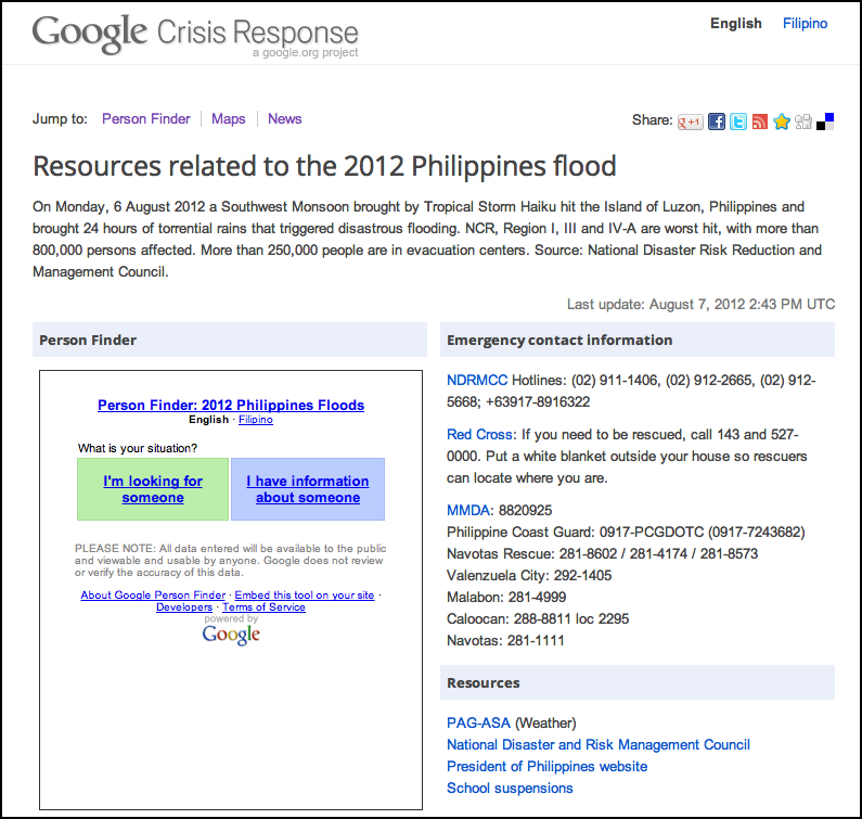
Floods in the Philippines: Google Person Finder, landing page with emergency information
August 7, 2012
A devastating Southwest Monsoon hit the Island of Luzon, Philippines, yesterday, triggering major flooding. The Crisis Response team has collected resources on to a new page to help in the aftermath of the floods, with information in both
Filipino
and
English
. The site features emergency contact information and links, a new instance of Google Person Finder, a map of shelter locations and flood information, and the latest news, powered by Google News and YouTube.
Person Finder
helps people submit or search for information about loved ones who may have been affected. The tool’s been translated into Filipino and can easily be embedded on any site:
We’re also able to share a map showing the locations of shelters and the extent of the flood, with real-time information from
Project NOAH (Nationwide Operational Assessment of Hazards)
:
View in a larger size
. This map will continue to be updated with additional information.
We hope that those affected find the tools and information useful. Check back, as we’ll be updating the landing page and maps with more information as it becomes available.
Posted by Aileen Apolo, on behalf of Google APAC and the Google Crisis Response team
U.S. Wildfires: New Google Crisis Map, Colorado imagery and more
June 29, 2012
To help provide relevant information related to the wildfires spreading through Colorado and Utah, the
Google Crisis Response
team has assembled a new
crisis map
for the 2012 U.S. wildfire season. The map features fire perimeters from the
U.S. Geological Survey
,
Red Cross
shelters in affected areas and new satellite imagery provided by
DigitalGlobe
, of the Waldo Canyon Fire near Colorado Springs. You can also see more authoritative, local-level data from sources including the
State of Colorado Division of Emergency Management
and the
Utah Division of Emergency Management
.
U.S. Wildfires map showing the perimeter of the fire near Colorado Springs.
View larger map
.
Use the checkboxes along the right-hand panel to turn on and off the layers of information, and the “Share” button at the top of the map to grab the URL or embed code. Note that both the URL and the embed code will automatically restore your current view of the map, including the set of layers that you have turned on.
New satellite imagery captured by DigitalGlobe on Thursday.
View larger map
.
You can also view the updated imagery in
Google Earth
to better understand the situation on the ground and its effects on these communities — just download
this KML file
. It includes both the optical and near-infrared images of the Waldo Canyon Fire, taken Thursday June 28.
Stay tuned for more map updates as we identify additional information for the wildfires. If you have data that you’d like to see included on the Google Crisis Map, contact us using
this form
and we’ll take a look.
Posted by Pete Giencke,
Google Crisis Response Team
Hosting a ‘Big Tent’ in Sendai, Japan on the role of technology when disaster strikes
June 8, 2012
When natural disasters strike, more and more people around the world are
turning to the web
,
social media
and mobile technologies to connect with loved ones, locate food and shelter, find evacuation routes, access medical care and help those affected, near and far.
Over the past few years, we’ve seen some powerful examples of technology helping people and organizations cope with disasters, including:
Families in Japan turning to person finder to
locate loved ones
feared lost;
Volunteers establishing
SMS services
and using
crowdsourcing tools
to collect information after the Haiti earthquake and engage the diaspora;
First responders using digital maps to coordinate efforts to
provide medical care
;
Students in New Zealand using social networks to form a volunteer army after the Christchurch earthquake; and
Online volunteer communities
self-organizing to provide emergency crisis-mapping services around the world.
This is really only scratching the surface of the amazing things people are doing, and we’re only beginning to understand the potential. So we’re hosting a
‘Big Tent’ event in Sendai, Japan on 2 July
to explore the growing role of technology in preparing for, responding to and rebuilding from disasters.
At this day-long forum, through a series of panel discussions, keynotes and technology demos, we hope to learn from some of the leading local and global, public and private sector voices on managing crises. The day's speakers will include:
Margareta Wahlström
, UN Special Representative of the Secretary-General for Disaster Risk Reduction;
Will Rogers of the
International Federation of Red Cross and Red Crescent Societies
;
James Kondo
, President of Twitter Japan;
Members of
Google’s Crisis Response team
, and many more.
We chose to host this event in Sendai - the largest city in Tohoku, the region devastated by last year’s Great East Japan Earthquake - to focus this forum on Japan’s impressive disaster response and recovery efforts, which demonstrated some new and innovative ways that technology can aid the efforts of responders to reduce the impact and cost of disasters.
While hard hit coastal areas remain bare, with only foundation lines to mark the many homes that have been lost, and too many families still living in shelters or temporary housing, central Sendai and much of the Tohoku region are beginning to buzz with new life and commerce as the community rebuilds. There is still a lot of work to be done, but
we’ve already learned a great deal
from this region and the inspiring response and rebuilding work being done by people in Japan and around the world, and we believe there’s much more for Google, public and private sector leaders, NGOs and technologists to gain by coming together here.
For those interested in joining us in Sendai, please register to attend
here
. Though space is limited, we’ll accommodate as many of you as we can.
Posted by Nigel Snoad, Crisis Response Product Manager
(Cross-posted on the
European Public Policy
,
Lat Long
and
Japan
blogs)
Labels
#streetview
#treasuremap
+1
3D
8bitmaps
Adwords Express
Africa
Amazon
Andorra
Android
api
Art Project
Audi
biking
Boost
Boulder
Brazil
Bulgaria
Business Photos
Business View
businesses
Canada
check-in
community
competition
contest
crisis response
Culture
custom maps
developer
Developers
directions
disaster response
discovery
earth outreach
education
Emmy Awards
Enterprise
Estonia
Europe
Explore
Fusion Tables
gadgets
Gibraltar
GMM
google
Google Earth
Google Earth Engine
Google Map Maker
Google Maps
Google Maps API
Google Maps Engine
Google Maps for Mobile
Google Maps Gallery
Google Maps Navigation
Google Maps Transit
Google Places
Google Plus
Google Search
Google Street View
google.org
Google+
googlenew
Grand Canyon
ground truth
Halloween
historical
history
holiday
Hotpot
Hungary
imager
imagery
Indoor Maps
iOS
iPhone
Iraq
Japan
Latitude
Latvia
layers
LBC
Lithuania
London
Making of Maps
Malaysia
Mall of America
Map Maker
Maps Blog
Maps Gallery
mapsgl
Matt Harding
Mexico
Mobile
Monticello
My Maps
my places
my tracks
National Geographic
navigation
new Google Maps
oblique imagery
ocean
offline maps
Olympics
Outreach
Pakistan
Panoramio
Parks Canada
Pegman
Photo Spheres
photo tours
photos
picasa
Polar Bears
Quiz
real estate
restaurants
road trips
Russia
Santa
Santa Tracker
search stories
SketchUp
Slovakia
Slovenia
South Sudan
space
Spain
sports
Street View
summer
SXSW
Tags
Thomas Jefferson
Thomas Jefferson Foundation
Tip of the week
tips
tour guide
traffic
Train
Transit
travel
trees
Trekker
Trike
Trolley
U.S. National Park Service
Ukraine
University of Virginia
Valentine's Day
Veterans Day
Views
voice search
walking
Waze
weather
webgl
Your Timeline
zagat
Archive
2016
Sep
Aug
Jul
Jun
May
Apr
Mar
Feb
Jan
2015
Dec
Nov
Oct
Sep
Aug
Jul
Jun
May
Apr
Mar
Feb
Jan
2014
Dec
Nov
Oct
Sep
Aug
Jul
Jun
May
Apr
Mar
Feb
Jan
2013
Dec
Nov
Oct
Sep
Aug
Jul
Jun
May
Apr
Mar
Feb
Jan
2012
Dec
Nov
Oct
Sep
Aug
Jul
Jun
May
Apr
Mar
Feb
Jan
2011
Dec
Nov
Oct
Sep
Aug
Jul
Jun
May
Apr
Mar
Feb
Jan
2010
Dec
Nov
Oct
Sep
Aug
Jul
Jun
May
Apr
Mar
Feb
Jan
2009
Dec
Nov
Oct
Sep
Aug
Jul
Jun
May
Apr
Mar
Feb
Jan
2008
Dec
Nov
Oct
Sep
Aug
Jul
Jun
May
Apr
Mar
Feb
Jan
2007
Dec
Nov
Oct
Sep
Aug
Jul
Jun
May
Feed
Google
on
Follow @googlemaps
Follow
Give us feedback in our
Product Forums
.


 Follow