The official blog for Google Maps
Community Celebration in Peru
August 31, 2010
[Cross-posted from the
SketchUp blog
]
Recently, a team of Googlers traveled to Peru and celebrated the winner (and community) of the
Google International Model Your Town Competition
.
Jorge De Albertis
of Lima won through a process where people all over the world voted for one of
five finalists
. His ability to win so many votes was a testament to the power of a community coming together to support Jorge’s efforts. His contribution creating 3D models of many of the
historical buildings
in the Barranco District of Lima has garnered a lot of attention in his country, and worldwide.
There were four majors parts to the celebration:
1. As part of the winning prize, Google gave a donation to a public school of Jorge’s choice. Jorge talked to the students and staff at a ceremony in the school’s courtyard, and we presented a large check to
IE 7053 Reino De Espana Public School
. Googlers helped students with a hands-on paper 3D modeling project, where they constructed models of the buildings Jorge submitted for the competition. The school graciously hosted a celebration for Jorge and Google, which included a welcome by student marching bands, traditional Peruvian dances, ballerinas, theater acts, singing, and a poetry jam.
Click here
to see more photos from the events.
2. Jorge and Google hosted a series of tech talks to over 80 design and architecture students and faculty at the University of Lima, explaining how others can get involved with modeling their communities. Demos were presented on Jorge’s project, SketchUp, Map Maker, and Building Maker.
Watch a video
of an interview of Jorge at the University of Lima.
3.
The Latin America International Film Festival
had a looping
video
of Jorge’s work running throughout the week.
4. Google held a celebration in Jorge’s honor at
Picas
, which was attended by designers, architects, educators, tourism officials, and the general Lima community. The fun-filled event had demo stations where people could learn more about Google Earth, Map Maker, Building Maker, and Google SketchUp. The band,
Colectivo Circo
played to a packed house. Jorge received a plaque and spoke to the community about his efforts. We are thrilled to have visited Jorge and to have met many people in the Lima community. Congratulations, Jorge!
Posted by Allyson McDuffie, SketchUp for Education Program Manager
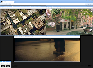
Street View and The Wilderness Downtown
August 30, 2010
Some of us now live far away from the places where we grew up, and I’ve often found something quite evocative and wistful about looking at photos of the streets where I used to live. A few of us decided to capture this feeling of nostalgia in an interactive music experience that we developed for the web.
The music experience, called “
The Wilderness Downtown
,” was created by writer/director
Chris Milk
, with the band
Arcade Fire
and several of us at Google. Drawing upon Street View in the
Google Maps API
as well as features made possible by
HTML5
, we created what we hope is a unique and deeply personal experience of traveling
down the streets where you grew up. All this is set to Arcade Fire’s new song “We Used to Wait” off their newly released album “The Suburbs.”
“The Wilderness Downtown” was made possible by recent developments in modern web technologies and modern browsers, and was built with
Google Chrome
in mind. As such, it’s best experienced in Chrome or an up-to-date HTML5-compliant
browser
.
You can launch the project and learn more about it on our Chrome Experiments site at
www.chromeexperiments.com/arcadefire
. Enjoy the trip down memory lane!
Posted by Aaron Koblin, Google Creative Lab
Defending the rivers of the Amazon
August 30, 2010
From time to time we invite guest posters to share their views on items relevant to the use of Google Earth. Here we have a post from Google Earth Outreach grantees
Amazon Watch
and
International Rivers
, two U.S.-based organizations that support Brazil’s
Movimento Xingu Vivo Para Sempre
. Amazon Watch and International Rivers have used Google Earth to animate what could happen if the Belo Monte Dam Complex were built on the Xingu River in the Amazon. We’ve offered them some space to share their work and thoughts with our readers.
Please note: This is a complicated issue with many facets, and the views of this poster do not necessarily represent the official viewpoint of Google Inc.; we support the use of Google Earth for visualizations to create dialog.
Today, Amazon Watch and International Rivers are releasing a new Google Earth tour and YouTube video called “Defending the Rivers of the Amazon," narrated by Sigourney Weaver, to draw attention to the impacts of the proposed Belo Monte Dam Complex on the people and ecology of the Xingu River.
If built, Belo Monte would be the world’s third-largest hydroelectric dam, and would divert the flow of the Xingu River, a massive tributary of the Amazon. It would flood the rainforest, displace more than 20,000 people, and generate greenhouse gases. On August 26th, the Brazilian government signed the concession to build despite protests by the region’s indigenous and local populations.
Download the “Defending the Rivers of the Amazon” Google Earth tour
The idea for the Google Earth tour emerged when “Avatar” director James Cameron and cast member Sigourney Weaver traveled to the Xingu River in April with Amazon Watch and the Brazilian
Instituto Socioambiental
(ISA). The launch of this Belo Monte Dam 3D animation is timed with the re-release of Avatar in theatres. James Cameron has also produced an informational video on Belo Monte called
“A Message from Pandora”
to highlight one of many real Pandoras on Earth.
Of course, it’s not all doom and gloom; the animation uses map overlays and 3D models to illustrate the potential for solar and wind energy as an alternative solution to meet Brazil’s future energy needs, using data from studies performed in the country.
But don’t take our word for it; watch the video, interact with the tour, and see for yourself. Then
follow the link
to take action. The people of the Xingu will thank you for it.
Posted by Atossa Soltani, Executive Director, Amazon Watch and Aviva Imhof, Campaigns Director, International Rivers
Remembering Hurricane Katrina
August 27, 2010
Before coming to Google, I worked at a
non-profit organization
that responded to Hurricane Katrina by sending mobile health clinics to the Gulf Coast, where there was critical shortage of medical and mental health care providers. I traveled through the region regularly for nearly two years following the storm and each time I would visit the same spots, trying to get a sense of how they were recovering. In some places I saw rapid change and in others hardly any.
Since moving to California I haven’t been able to get back to the Gulf, but I think about that time often. I was excited back in 2008 when we made
Street View imagery of New Orleans
available, and I’ve kept track of updates to our overhead imagery of the area in Google Earth and Maps.
With the fifth anniversary of Hurricane Katrina approaching, my mind has been with the hardworking and resilient residents of coastal Louisiana and Mississippi. I used the Historical Imagery feature in Google Earth to look back at some of the places I used to visit, and created these slideshows to show the change over time.
These by-now-familiar images of the Lower Ninth Ward are no less heartbreaking today than they were when we first saw them.
The Biloxi Bay Bridge, which connects Biloxi to Ocean Springs, MS, was heavily damaged in the hurricane and had to be rebuilt. The new bridge opened to traffic in November, 2007.
Posted by Kate Hurowitz, Lat Long Blog Team
Go East!
August 27, 2010
The Google Earth and Maps Imagery team has just finished rolling out new imagery across the globe, including a significant amount of aerial imagery in Eastern Europe. It's been a while since we had a big update in that part of the world, and there are a ton of fantastic sights for all you armchair geographers out there to explore. Break out the Slavic dictionary, crank up the techno, and start zooming in!
Wawel Castle, Krakow, Poland
Airport/Racetrack, Dolna Mitropoliya, Bulgaria
Struga, Macedonia
High Resolution Aerial Updates:
USA: Pittsburgh, Kane County (IL)
Poland: Krakow, Tarnow, Nowy Sacz, Bielsko-Biala, Zory, Chorzow, Krosno, Kolbuszowa, Chorzow, Czestochowa, Kielce, Radomsko, Belchatow, Skarzysko-Kamienna, Kielce, Starachowice, Radom, Ostrowiec, Pulawy, Zamosc, Jelenia Gora, Swidnica, Glogow,
Czech Republic: Vysocina, Jihomoravsky, Olomoucky, Moravskoslezsky
Macedonia: entire country
Countries receiving High Resolution Satellite Updates:
Cuba, El Salvador, Costa Rica, Colombia, Venezuela, Peru, Brazil, Bolivia, Argentina, Chile, Uruguay, Morocco, Algeria, Egypt, Senegal, Mali, Guinea, Ivory Coast, Ghana, Murkina Faso, Nigeria, Benin, Chad, Cameroon, Central African Republic, Sudan, Ethiopia, Somalia, Kenya, Tanzania, Zimbabwe, Zambia, Angola, Botswana, South Africa, Madagascar, Saudi Arabia, Oman, Kuwait, Jordan, Israel, Russia, Estonia, Latvia, Lithuania, Hungary, Slovenia, Bulgaria, Iran, Pakistan, India, China, Myanmar, Cambodia, Indonesia, Australia, New Zealand, The Philippines, Japan, North Korea, Mongolia
Countries receiving Medium Resolution Satellite Updates:
Myanmar
These updates are currently only available in Google Earth, but they'll also be in Google Maps soon. To get a complete picture of where we updated imagery, download
this KML
for viewing in
Google Earth
.
Posted by Matt Manolides, Senior Geo Data Strategist
Guidance and Updated Policies for Writing Reviews
August 25, 2010
Three years ago we launched
reviews for places on Google
so that you could share your opinion of any place in the world. Your reviews help other users find places that are right for them.
We encourage you to continue sharing your experiences and opinions -- both good and bad. At the same time, we want to ensure that the information posted in reviews is useful and relevant for everyone. So today, we’ve updated and clarified the
guidelines and policies for writing reviews
. These guidelines help to make sure that reviewers understand how to write thoughtful reviews, that readers will find them informative, and that the content of the reviews provide useful feedback for Google Places business owners. We’re also sharing more information about when and why some reviews may be removed from a Place page. Below is a quick summary of the updates. Be sure to review the
updated policy
for more details.
Tips for writing great reviews
There isn’t an exact formula to writing a great review. Reviews are best when they reflect the unique opinion and viewpoint of an individual. You can share as much or as little information as you’d like: you might choose to describe the intricate details of a restaurant’s decor, or simply recommend your favorite dish. In the updated policy, you’ll find several best practices to consider when reviewing a business. These tips can help you convey your personal opinions clearly and effectively.
Does Google remove reviews?
The short answer is yes. Reviews are intended as a way for people to share useful and relevant information. That encompasses a wide range of opinions, most of which are permitted by our policy. However, in instances in which a review is in violation of our policy, we will remove the review. It’s important to remember that negative reviews aren’t against our policy. We encourage you to share your honest opinions about a business. And if you’re a business owner, you can
directly respond to reviews
to share your side of the story.
The process for reporting a review that violates our policies hasn’t changed. You can still report a review using the
Flag as inappropriate
link found next to each review submitted through Google Maps. When a review is flagged, we'll check to determine if the review violates our guidelines and take action accordingly.
This policy update is our latest step in our ongoing effort to improve your experience with business reviews. We hope you continue to voice your experiences, thoughts and opinions of the places you visit!
Posted by Stephen Seyboth, Product Manager
Street View Imagery Available in Building Maker
August 24, 2010
[Cross-posted from the
SketchUp blog
]
If you’ve ever modeled a building in
Google Building Maker
, you may have found yourself wanting to use crisper, more detailed photos in addition to the aerial oblique imagery. Or, you may have had problems with poor textures caused by other buildings blocking the view of your building. In response to these issues we recently added the ability to
add your own photos to Building Maker
, but now you can also use imagery directly from
Street View on Google Maps
!
Start modeling your building using the aerial imagery. After you have constrained a block in at least two aerial images, you will be able to “Add Street View Images” from a drop down menu on the left-hand side. Capture a few images from Street View and continue modeling as normal. The following video illustrates an example of using this new feature:
We have also added 6 new cities to Building Maker (all, with the exception of Vienna, have Street View imagery!):
Edinburgh, United Kingdom
Florence, Italy
Vienna, Austria
Pittsburgh, PA, United States
Santa Cruz, CA, United States
Riverside, CA, United States
Try modeling with Street View imagery in
Google Building Maker
now!
Posted by Nicole Drobeck, Geo Community Advocate
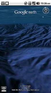
Dive into the ocean with Google Earth for Android
August 23, 2010
Especially during the summer months, staring out into the ocean leads to daydreams of sailing the open water, freedom and exploration. Now you can take three-quarters of this vast planet - the ocean - with you on your mobile device by downloading the new Google Earth 1.1 for Android.
With the release of this feature, you can escape the hustle and bustle of life on land and discover the marine world using Google Earth on your mobile device. For example, check out the landscape and terrain in Monterery Bay Canyon, which is larger than the Grand Canyon, by zooming in on Google Earth below the ocean surface just off the coast. Once underwater, you can use the “look around” button to tilt the view and see the extent of this great undersea canyon.
The latest version of Google Earth for Android also introduces the “Explore the Ocean” layer, which features hundreds of photos and videos from more than 100 contributors who are excited to share their stories of the sea. Plan or get a sneak peek of your next vacation during your daily commute by clicking on any of the little blue icons. The gold highlighted icons represent content from the
Mission Blue Hope Spot initiative
.
For those of you running Android 2.2, there are some more treats in store. Google Earth now supports Flash in balloons, so if you have the Flash player installed on your mobile device, you can watch videos right in the balloon. We’ve also made the program easier to navigate; for most devices, you can now use two fingers to “look around” and change your viewpoint, as an alternate to using the on-screen button. This makes it even easier to tilt your view to see mountainous landscapes or underwater canyons.
Google Earth for Android 1.1
is available in the Android Market today for most Android devices running version 2.1 or later. Explore the ocean anywhere.
Posted by Jenifer Austin Foulkes, Product Manager
To 100 million and beyond with Google Maps for mobile
August 19, 2010
[Cross-posted from the
Google Mobile Blog
]
Almost five years ago, we launched
Google Maps for mobile
to help you get where you needed to go from your phone instead of a paper map. Today, more than 100 million people a month are now using Google Maps for mobile to get from point A to point B, find nearby places, and more.
Over the past five years, Maps for mobile has changed quite a bit, adding more ways to help you explore the world around you. With
My Location
, you can quickly find where you are on the map with or without GPS. You can put your friends on the map with
Latitude
.
Navigation
even turns your phone into a free internet-connected navigation system with voice guidance and Street View imagery.
Lately, we’ve been especially focused on helping you find the right place at the right time. With recent additions such as Place Pages, you can now pick a nearby place by browsing information such as opening hours and review snippets for the places around you. It’s easier than ever to find those places with
Search by voice
or the
new Places icon on Android
. With this latest Android version, we’re happy to see that you’re now searching for places almost three times as often, doubling how many Place Pages are seen a day.
Search result page for Java-enabled phones in 2005 (left) and Place Page for Android-powered devices in 2010 (right).
Search experience in 2005 (left) and Places for Android-powered devices in 2010 (right).
We hope this is just the start of how Google Maps for mobile will continue to evolve and let you explore the world right from your phone. We’re always inspired by how you’re using Maps, and we’d love to hear about a time when you found the nearest mechanic for a flat tire or discovered that hidden gem of a burger joint. If you have a
Google story
about when Maps for mobile has helped you, please
tell us about it
. You can also share quick stories on Twitter
@googlemobile
, and we’ll share our favorite ones. From all of us here on the Google Maps for mobile team, 100 million thank yous for getting your Google Maps to go!
If you’re a business owner, help millions of people find you by claiming your free Place Page available in Google Maps and our most used mobile “app” -- Google Search. Get started at
places.google.com/businesses
.
Posted by Vic Gundotra, Vice President of Engineering
Heroic Defenders of Wildlife organization maps oil spill cleanup efforts
August 19, 2010
Update: please visit the
Conservation Registry
for an updated map of the Gulf Oil Spill relief efforts.
For a period of several months, 50,000 to 60,000 barrels of oil per day flowed from the site of the Deepwater Horizon well straight into the Gulf of Mexico. After the initial explosion on April 20th, the first reports of oil sightings on the coastlines began on June 1st. People living and working along the shoreline spanning Louisiana, Mississippi, Alabama and Florida saw clumps of crude oil on their local beaches. That was followed by reports of birds, dolphins, fish and sea turtles covered in slick black oil.
In the aftermath of the largest environmental disaster in U.S. history, environmental groups across the country have been rallying in support of both immediate coastal reparation and long-term solutions for the damage the Gulf Oil Spill has wreaked on the ecosystem. With those goals in mind, Washington, D.C.-based
Defenders of Wildlife
, an organization dedicated to protecting species and the habitats on which they depend, is doing everything it can to raise awareness and action for greater cleanup and conservation.
The organization is working to educate policymakers about the importance of protecting wildlife and securing a moratorium on further offshore drilling. In addition, Defenders of Wildlife has been issuing
ongoing reports
on the number of birds, sea turtles and marine mammals found covered in oil along the coast. As many as 400 different species of animals are projected to be impacted by the environmental nightmare. Since massive cleanup activities are being led by a number of environmental groups, Defenders of Wildlife also decided to use their powerful mapping platform called the
Conservation Registry
to track the collective efforts of all the various groups into one comprehensive map.
Oiled Wildlife Ticker, updated each day to track the numbers of animals that have been impacted by the spill
This
Gulf Oil Spill Recovery map
was created using the Google Maps API and the Google Earth API. It allows any users, whether they’re part of a non-profit group or concerned citizens who want to report what they observe in their backyards, to upload stories, photos and video to the common shared map. The result is an impressive illustration of all the projects - from beach cleanups to air monitoring surveys to sediment sampling - going on in the region to help rescue and restore affected species and their habitats. The map also shows numerous steps that the Obama Administration is taking to mitigate the near- and long-term impacts of the spill. As the map evolves, you’ll be able to see how the marine environment and coastlines recuperate from collaborative efforts by average people, non-profit organizations and government agencies.
Through this video, our most recent
Google Earth Hero
, Defenders of Wildlife, shares more about the creation of the Gulf Oil Spill Recovery application. Their hope is that it will not only help people visually understand the scope of the spill and recovery work, but also spur volunteers into taking action and getting involved themselves. Additional data contributed by Defenders of Wildlife, news and user videos can also be found on the
Google Crisis Response oil spill recovery site
.
Posted by Tanya Keen, Google Earth Outreach Program Manager
A Big Thank You to our Growing Community of Bike Map Contributors
August 18, 2010
When we added U.S. biking directions to Google Maps
back in March
, we were eager to see the response from the cycling community. Through our partnership with the Rails-to-Trails Conservancy, we had detailed bike lane and trail information for 150 cities; and for the rest of the country, we recommended routes based on other data such as the size of the road, speed of traffic and hill steepness. On one hand, it would’ve been ideal for our directions feature to know about all the bike lanes and trails in the country. But on the other hand, we were aware that biking directions were one of our most-requested features and we wanted to provide information for bicycling fans as soon as possible.
So rather than wait, we decided to launch biking directions in “beta” and ask our community of bicycle-bound users for their help improving our bike maps. Through our “
Report a problem
” tool, any user can send us corrections or recommend improvements, and receive notifications from Google when their report has been resolved. We always knew the cycling community would be a passionate bunch, but the response to both our biking directions feature and our call to join in the effort to improve our bike maps has surpassed our happiest expectations.
More than 10,000 people have submitted about 25,000 suggestions for improvements to our bike maps. With their help, we’ve added bike lane and trail data for an additional 80 cities since our initial launch. This is an exciting and humbling response from the Google Maps community. It’s like having 10,000 new members of our bike maps team, contributing their time and energy to make Google Maps more useful for everyone.
These contributors have impacted biking directions across the nation - in small and large ways. Here are some examples of suggestions we’ve received:
One user simply pointed out to us,
“Wall Township Bike path - http://www.wallrec.com/bicycling.htm.”
Our response to that short and sweet message?
Here it is
:
Some else sent a note saying,
“CSUS - there has been a bike/foot traffic tunnel that connects elvas ave to College town dr for about 6 years. it is located between 64 & 65 st.”
Well, that’s handy to know!
Done
:
And yet another user shared,
“Cycle/hiking path continues to the East across Switzer and connects with the path that is currently shown on google maps ~2.5 miles to the ENE at 130th and Metcalf Ave. Details on Overland Park website http://www.opkansas.org/Resource_/PageResource/Maps-And-Stats/Maps/Adobe-Acrobat-PDF-Maps/bike_route_plan.pdf Thanks.”
Awesome! Overland Park is now
looking pretty good
for cyclists:
This is how we’ll build a great cycling map: Bit by bit, getting better with every tip and suggestion that users share about the lanes and trails they’ve ridden.
We want to say “Thank you!” to all those who’ve answered our call for bike map contributions. Clearly our users are passionate about helping to make our maps better, so we’re working hard to make the improvement process even easier and to speed up the processing time for user contributions.
In the meantime, happy biking! Just remember that our biking directions are still in beta, and to always use your judgement - don’t ride down any road that makes you uncomfortable. And if we’ve recommended a road that shouldn’t be used by the average bicyclist,
let us know
!
Posted by Dave Barth, Product Manager
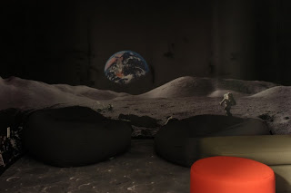
Making our new building home
August 16, 2010
This past June, our Geo team finally outgrew our space, so it was time to move to a larger building on campus. To make sure our new building really felt like a home away from home, some of us got involved in the design planning and made it our mission to surprise everyone with a unique, inviting and very Googley new place to work.
We gave the new building a quintessentially Geo feel by putting
map-themed artwork
in the lobby and halls. We also decided to make quirky, fun places like the “Moon room,” complete with the Earth rising on the wall, moon rocks to nap on, crater-laden carpet and twinkling stars above.
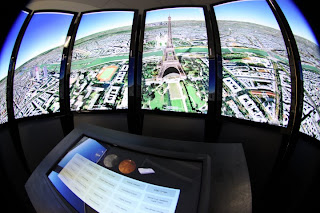
Then we added a
Liquid Galaxy
for Googlers and visitors to explore Google Earth on eight stunning LCD panels. Given that it’s right next to the café, we recommend that you use the Liquid Galaxy before eating, because swooping and zooming around in Google Earth in an immersive panorama can get a little intense.
Despite all of these geographic references, we heard that the new building’s layout had everyone confused! After plastering the walls with building floor plans and “You are here” stickers, we decided on two more creative solutions. First, we designed two “hiking trail” style sign posts for each floor so that folks could quickly find meeting rooms, which we named after famous explorers!
Second, we devised a contest for teams to design “road signs” to hang above their cubes, notifying visitors and lost team members where to find them. Teams had a couple weeks to craft and submit their design for a little friendly competition. While all the signs were being printed and hung, we encouraged everyone in the building to vote for their favorite signs. My personal favorite is the double-sided one created by the Google Earth team.
Photos courtesy of Brian Kiley.
Now, after seeing all the fun signs hanging throughout the building, teams that didn’t participate in the contest are rallying for a second round of sign design. All in all, the dust has settled, and everyone seems quite happy with our new digs.
Posted by Tai Kuncio, Administrative Assistant
Google Earth Enterprise 4.0 now available
August 13, 2010
[Cross-posted from the
Google Enterprise Blog
]
The Google Earth Enterprise team has long focused on bringing the innovative features of Google Earth and Maps to businesses, enabling them to create their own mapping applications from their existing data archives. Over the years we’ve released new features that have expanded the options for rapid, secure dissemination of geospatial data with
Google Earth Enterprise
(GEE), and with today’s release of GEE 4.0, we’re happy to announce support for two more important capabilities: mobile-based access to GEE systems, and
Google Earth Enterprise Portable Solution
. We’re also excited to let you know about the latest versions of the Google Earth Enterprise Client and Plug-in.
Mobile Access to your Globes
In February we released a native
Google Earth client for Android
to the Android Market. With GEE 4.0, the Android Google Earth client has been updated to support direct connections to customers’ globes, which permits their end-users to view their organization’s 3D globe, including all imagery, terrain, and vector layers, with support for custom vector search.
Google Earth Enterprise Un-Plugged
Some of you might have heard during a recent
Directions Media Webinar
that many of our GEE customers need to provide their end users with access to geospatial data for situational awareness, even when those users are in environments with limited or no Internet connectivity. To support this, GEE 4.0 introduces a new feature that permits authenticated end users to extract portions of a published GEE globe -- including all imagery, terrain, vectors, KMLs, and search -- and serve the data locally from their own laptops or other storage devices using a native, cross-platform, light-weight Portable Earth System.
Check out this video to see how the portable capability works.
Google Earth Enterprise Client 5.2
GEE 4.0 also has full support for the new
Google Earth 5.2 client
, with its many great new features, such as elevation profiles, native MGRS support, client-side data regionation, and the new embedded web-browser.
Google Earth Plug-in Updates
In addition to performance improvements, the latest release of the Google Earth Plugin includes support for historical imagery databases and the ability to connect to multiple globes simultaneously.
Existing customers can find GEE 4.0 upgrade information by logging into the Google Enterprise Support Portal.
Posted by Posted by Dylan Lorimer, Google Earth and Maps Product Manager
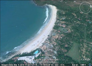
Beachcombing for New Imagery
August 12, 2010
If you're anything like me, you can't get enough of beaches during the summer months. There are few activities as relaxing as sitting by the water, reading a book, and enjoying a cool beverage. This week's imagery update includes a number of great beaches, so if you live nearby, you may want to go soak up some sun. Just remember to bring your sunscreen!
Chicago, Illinois beach
Goa, India beach
Atlantida, Uruguay beach
Of course, it's only summer in the Northern Hemisphere, so be sure to put Uruguay on your list for future travel rather than flying over there now!
High Resolution Aerial Updates:
USA: Chicago, Stockton, Modesto, Nez Perce (ID), Barre (VT), Orange County (NC), Polk County (FL), Hardee County (FL), Okeechobee County (FL)
Uruguay: Salinas, Atlantida
Countries receiving High Resolution Satellite Updates:
Mexico, Guatemala, Nicaragua, Colombia, Venezuela, Brazil, Peru, Paraguay, Argentina, Chile, Morocco, Libya, Egypt, Senegal, The Gambia, Guinea, Ghana, Burkina Faso, Nigeria, Cameroon, Chad, Sudan, Ethiopia, Djibouti, Kenya, Uganda, Congo, The Democratic Republic of the Congo, Angola, Zambia, Mozambique, Zimbabwe, Botswana, South Africa, Madagascar, Jordan, Syria, Turkey, Russia, Iran, Pakistan, India, Sri Lanka, Bangladesh, China, Myanmar, Thailand, Vietnam, Japan, The Philippines, Indonesia, Australia, New Zealand
Countries receiving Medium Resolution Satellite Updates:
Canada, Guatemala, Belize, Honduras, Nicaragua, Benin, Togo, Ghana, Uganda, Kenya
Right now these updates are only available in Google Earth, but will be in Google Maps soon. For a complete picture of where we updated imagery, download
this KML
for viewing in
Google Earth
.
Posted by Matt Manolides, Senior Geo Data Strategist
Seeking map data in response to Pakistan floods
August 6, 2010
According to the UN, the
recent floods in Pakistan
have affected over 4 million individuals - and the human toll continues to grow. Disease is an ever-increasing risk as relief agencies rush to the aid of those who have been hurt or displaced.
Google’s Crisis Response team has provided satellite imagery and
KML layers
to assist relief efforts in past disasters, including the
Haiti earthquake
and recent
Gulf of Mexico oil spill
. In Pakistan, however, the cloud cover over the impacted areas has inhibited our ability to make this valuable content available. The Crisis Response team is looking to collect and aggregate imagery and user generated KML, or other map data, with the goal of making this content more accessible to both crisis responders and the general public. We’re hoping you can help. You can submit links to KML and map data via the following
form
. We’ll contact you if we are able to publish your content.
Loading...
View
BKTEF Relief Activity
in a larger map
Further, we’ve released a version of our
Person Finder tool
in Urdu. We realize many of the victims of this disaster lack any connectivity to the Internet, but remain hopeful that tools like this can assist the diaspora and general disaster community in collecting and dispersing information on the well-being of those impacted.
Your data might help relief efforts; we appreciate you sharing it with the world.
Posted by Steve Hakusa, Software Engineer, Google Crisis Response Team
Introducing the Google Small Business Blog
August 5, 2010
Most every business, including ours,
starts small
. These days, technology is giving businesses even more ways to grow bigger... faster.
In our recent
Small Business series
on the Official Google Blog, a handful of real-life entrepreneurs have shared their experiences building companies from scratch and embracing Internet tools that have taken their businesses to the next level. We’ve received fantastic feedback about these posts, and realized that there’s a healthy appetite among small- and medium-sized business owners who want to know all about the latest web tools and tricks. Fortunately, we have lots more to share with you, too!
That’s why we’re introducing the
Google Small Business Blog
, a central hub that brings together all the information about our products, features and projects of specific interest to the small business community. Rather than having to sleuth around in many different locations for details about
templates for creating video ads on YouTube
,
tips for your employees using Gmail
or
how to respond to the business reviews on your Place Page
, you can find all of this helpful information right here in one place.
Of course, we’ll continue to post relevant news about individual services such as
AdWords
,
Apps
,
Google Places
and
YouTube
on their respective
“home” blogs
, but feel free to visit or subscribe to the
Google Small Business Blog
to get everything relating to your small business needs. We’re starting small today, but who knows what tomorrow will have in store!
Posted by Deanna Yick, Small Business Blog Team
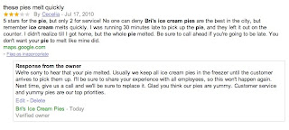
Respond to reviews for your business on Google Place Page
August 4, 2010
Whether you’re looking for a great lounge to hang out with your friends or a trusty shop to repair your bicycle, the web is a great place to discover and learn about local businesses and services. Some of the listings on
Google Maps
showcase reviews to help prospective customers make informed decisions and find the places that are just right for them. Reviews on Google Maps are assembled from a variety of sources on the web to give you the best possible overview of what people are saying about a specific place. We also encourage users to share their opinions by writing reviews directly on the
Place Page
of any place they’ve visited, be it a local business, tourist attraction or the like.
Starting today, if you’re a verified
Google Places
business owner, you can publicly respond to reviews written by Google Maps users on the Place Page for your business. Engaging with the people who have shared their thoughts about your business is a great way to get to know your customers and find out more. Both positive and negative feedback can be good for your business and help it grow (even though it’s sometimes hard to hear). By responding, you can build stronger relationships with existing and prospective customers. For example, a thoughtful response acknowledging a problem and offering a solution can often turn a customer who had an initially negative experience into a raving supporter. A simple thank you or a personal message can further reinforce a positive experience. Ultimately, business owner responses give you the opportunity to learn what you do well, what you can do better, and show your customers that you’re listening.
Before writing your first response, we recommend reading our handy tips on
how to respond to reviewers
. Then take a stab at responding by following these
instructions
. If you have not yet verified ownership for your business on Google, please visit
Google Places
to claim your listing.
Posted by John Maguire, Google Place Page team
Labels
#streetview
#treasuremap
+1
3D
8bitmaps
Adwords Express
Africa
Amazon
Andorra
Android
api
Art Project
Audi
biking
Boost
Boulder
Brazil
Bulgaria
Business Photos
Business View
businesses
Canada
check-in
community
competition
contest
crisis response
Culture
custom maps
developer
Developers
directions
disaster response
discovery
earth outreach
education
Emmy Awards
Enterprise
Estonia
Europe
Explore
Fusion Tables
gadgets
Gibraltar
GMM
google
Google Earth
Google Earth Engine
Google Map Maker
Google Maps
Google Maps API
Google Maps Engine
Google Maps for Mobile
Google Maps Gallery
Google Maps Navigation
Google Maps Transit
Google Places
Google Plus
Google Search
Google Street View
google.org
Google+
googlenew
Grand Canyon
ground truth
Halloween
historical
history
holiday
Hotpot
Hungary
imager
imagery
Indoor Maps
iOS
iPhone
Iraq
Japan
Latitude
Latvia
layers
LBC
Lithuania
London
Making of Maps
Malaysia
Mall of America
Map Maker
Maps Blog
Maps Gallery
mapsgl
Matt Harding
Mexico
Mobile
Monticello
My Maps
my places
my tracks
National Geographic
navigation
new Google Maps
oblique imagery
ocean
offline maps
Olympics
Outreach
Pakistan
Panoramio
Parks Canada
Pegman
Photo Spheres
photo tours
photos
picasa
Polar Bears
Quiz
real estate
restaurants
road trips
Russia
Santa
Santa Tracker
search stories
SketchUp
Slovakia
Slovenia
South Sudan
space
Spain
sports
Street View
summer
SXSW
Tags
Thomas Jefferson
Thomas Jefferson Foundation
Tip of the week
tips
tour guide
traffic
Train
Transit
travel
trees
Trekker
Trike
Trolley
U.S. National Park Service
Ukraine
University of Virginia
Valentine's Day
Veterans Day
Views
voice search
walking
Waze
weather
webgl
Your Timeline
zagat
Archive
2016
Sep
Aug
Jul
Jun
May
Apr
Mar
Feb
Jan
2015
Dec
Nov
Oct
Sep
Aug
Jul
Jun
May
Apr
Mar
Feb
Jan
2014
Dec
Nov
Oct
Sep
Aug
Jul
Jun
May
Apr
Mar
Feb
Jan
2013
Dec
Nov
Oct
Sep
Aug
Jul
Jun
May
Apr
Mar
Feb
Jan
2012
Dec
Nov
Oct
Sep
Aug
Jul
Jun
May
Apr
Mar
Feb
Jan
2011
Dec
Nov
Oct
Sep
Aug
Jul
Jun
May
Apr
Mar
Feb
Jan
2010
Dec
Nov
Oct
Sep
Aug
Jul
Jun
May
Apr
Mar
Feb
Jan
2009
Dec
Nov
Oct
Sep
Aug
Jul
Jun
May
Apr
Mar
Feb
Jan
2008
Dec
Nov
Oct
Sep
Aug
Jul
Jun
May
Apr
Mar
Feb
Jan
2007
Dec
Nov
Oct
Sep
Aug
Jul
Jun
May
Feed
Google
on
Follow @googlemaps
Follow
Give us feedback in our
Product Forums
.


 Follow