The official blog for Google Maps
All your Google Maps searches in one place
September 19, 2012
When you’re on the go, it can be difficult to recall all of the places you’ve searched on your desktop browser at home. To make Google Maps more useful and comprehensive, we added a few improvements to better sync your maps experience across all of your devices. Today, with the latest release of
Google Maps for Android
, we’re making it faster and easier for you to get the information you’ve searched for on your browser, right on your Android phone.
Just make sure you’re signed in to Google Maps and your
web history
is enabled to get a number of new benefits including search and directions history. When you start to type a place or directions into the search box on your Android device, you’ll see suggestions for directions and locations that you’ve previously searched for – making it easier to quickly find directions on the go.
Desktop and Mobile search synchronisation.
You can also see your mapping search history, as well as your directions history, on your Android phone by going to the “Search” or “Directions” tab under My Places. This way, places and businesses you have already searched for will show up in your suggestions to save you time when you’re out and about.
Access your search history under My Places.
Also, as in previous versions of Google Maps for Android, when you chose to
set locations such as “home” and “work
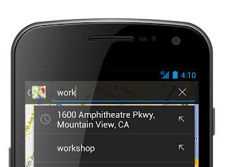
", you can quickly access directions to these places by simply typing “home” or “work” in the search field on your mobile device.
Searching for work automatically suggests your work address.
We’re always working to make your Google Maps experience more comprehensive, accurate and useful across all devices. To learn more about these features you can
visit our site
.
Posted by Keiji Maekawa, Software Engineer, Google Maps
An easier way to find panoramic interior imagery in Google Maps
September 18, 2012
Together with thousands of participating businesses owners
around the world
, we’ve been working hard to improve the comprehensiveness of interior, panoramic imagery available on Google and Google Maps.
Now, if you’re searching or browsing Google Maps and want to check out what a business looks like on the inside, we’ve improved your ability to find and view these 360-degree panoramics. Simply drag and drop the orange Pegman on the left hand side of your screen onto an orange circle on the map. Voila! You’ll be virtually transported through the doors, and able to pan around and explore the interior of the establishment.
Drop Pegman on the orange dots to get 360 degree interior views of participating businesses
From restaurants to retail shops to beauty salons and more, these interior
Business Photos
on Google Maps give you the feeling of being there, and the comfort of knowing what to expect when you arrive. Whatever the occasion, they can help you find a place with the right ambiance for a
dinner date in Orlando, Florida
,
a resort in Canary Islands, Spain
, or even preview an
antique store in Austin, Texas
.
To give you an even better idea of where and how you can find these helpful interior Business Photos, watch this video. Then let Google Maps help you explore the interiors of the participating places in your area.
Posted by Shailesh Nalawadi, Product Manager
Google Maps shows how we spent summer 2012
September 13, 2012
In the blink of an eye, summer is coming to an end. It feels like it was just yesterday that I was planning out all my summer activities as I eagerly awaited the start of long, sunny days and warm nights.
Before we approach the official end of summer on September 21, our
Google Maps
team thought it’d be fun to see how those of us in the Northern Hemisphere have spent the dog days. To do this, we reviewed the summer search activity on maps.google.com in several countries between the end of May and the beginning of September. Within each country, a look at some of the top-rising searches and the often-searched landmarks on Google Maps gives us a sense of how people around the world spent their summers.
We’re honored that people rely on the comprehensive and accurate imagery in Google Maps to research, plan, preview and digitally experience distant as well as local destinations across the globe. Take a look and
click through for a larger image
:
North Americans sought out the best local beaches to help cool off from the summer heat. In comparison, many more people from Spain, Italy and France searched for community swimming pools. In cooler areas of the U.K. the rising Google Maps searches included many indoor activities such as squash, bars and going to the gym. And, as expected, travel was a clear choice for the summer, as indicated by a surge in searches for lodging in almost every region.
Many popular destination searches were located outdoors. National parks and Hawaiian islands were the most popular searches in the U.S., while local parks, zoos, gardens and playgrounds topped Canada’s and Europe’s list. Major landmarks such as the Empire State Building in New York City, Niagara Falls in Canada, the Eiffel Tower in Paris, and the Taj Mahal in India also topped the list of often-searched places in Google Maps. And of course, with the Summer Games drawing in international audiences, Wembley Stadium and the Olympic Stadium were two of the most searched for locations throughout the UK this summer.
Check out the destinations that captured people’s attention this summer and see how your interests compared to others around the world. We hope you enjoy this look back to remember the fun places we all went with Google Maps this summer, and we can’t wait to help you
find your next adventure
!
Posted by Manik Gupta, Sr. Product Manager, Google Maps
Elephants in Peril
September 12, 2012
Editor’s note:
Today’s guest authors are Rob Heittman from Solertium, Inc., a technical development company and Iain Douglas-Hamilton, founder of Save the Elephants, based in Kenya.
Save the Elephants
was the recipient of a
Google Earth Outreach Developer Grant
, funded through the Google Inc. Charitable Giving Fund at the
Tides Foundation
. We’re hoping that mapping data patterns over time will shed much-needed light on the recent dramatic increase in poaching of elephants in Africa.
History is currently repeating itself in a quite unpleasant way.
Once again, as we did in the 1970s and 1980s, we are seeing previously tranquil elephants affected by huge surges in the illegal killing of elephants for ivory. We know, from past experience, that this ivory rush is fueled by a sudden increase in demand: new prosperity in Asian markets, where ordinary people can suddenly afford to buy ivory. After a relative respite since the 1989 ivory trade ban, I am sad to report that elephants are once again in peril.
Murembo, a bull elephant, from Tsavo National Park, Kenya
Photo Credit:
Johan Marais
Save The Elephants
operates a research camp in Samburu, Kenya; a very special place. The elephants there are protected by law, the ceaseless efforts of the Kenya Wildlife Service, local stakeholders, and amazing technology that helps secure their future. Within Samburu -- and other places in Africa -- we provide a tracking system which uses GPS radio collars to monitor the movements of elephants in near real time. Using
Google Earth
and our new, lightweight mobile apps, our team can be deeply knowledgeable about the Samburu elephants, and share data with the guardians to come to their aid if needed. Alerts tell us when unusual conditions occur. The most serious alert concerns immobility. This too often means another poaching incident, and another elephant's life lost to runaway demand for ivory.
Save the Elephants’ private Android and iOS apps allow for real-time elephant tracking, alerting rangers to elephants movements and poaching incidents.
We believe the ivory poaching we're seeing is a microcosm of what is going on across Africa. This past year, especially, there have been a series of massacres, for example, one in Cameroon in which almost an entire population was wiped out with automatic weapons.
Just 10 years ago, the areas in red, where illegal elephant killing is peaking, were showing healthy or stable elephant populations in green. Explore the changes over time in the timelapse feature. Since 2008, major deterioration set in.
The other necessary part of the solution is to reduce the demand. Here, technology can also be a powerful ally. We are now using new Google technologies to bring the same level of awareness to anyone with a Web browser. With our most recent initiative, the Elephants in Peril site (
http://www.elephantsinperil.org
), we have turned to
Fusion Tables
and
Google Maps Engine
to do two important things. First, we are working to bring together public data sets, often buried in boring official reports, to reveal the complete story of elephant populations over time, map them out, and understand what trends can be seen. Second, we aim to share the real, unvarnished scientific data from whatever sources in a citable, and highly usable form.
As long as elephants continue to be threatened by surging ivory demand, we want Elephants in Peril to become a reliable source, whether a visitor wants to learn about the problem, write, tell about it, or take steps to help solve it. Google's simple data publishing and visualization tools make it possible for us to undertake this effort and reach a larger audience than would otherwise be possible.
elephantsinperil.org
map shows main populations left in Africa with green being high density and red being low density.
We are in a race with the poachers; a race we have to win. Google Earth, Google Maps Engine, and Fusion Tables give us the advantage of speed. Already, we have used the system to share results with the media, and save weeks or months in achieving publicity. Later this year, we will publish original research that helps to tie our findings in Samburu to the challenges across the African continent, using the site to engage concerned individuals, NGOs and governments. In future, we look forward to translating the site into Chinese to improve its utility as a resource in Asia.
Google Earth Outreach and the Tides Foundation have made our mobile apps and Elephants in Peril possible. We welcome the assistance of any concerned Google developers or users. Please visit
our website
; even better, visit us in Africa if you can, and
give us your ideas
to help us win this race.
Posted by Dr. Iain Douglas-Hamilton, Founder of Save the Elephants, and Rob Heittman, CTO of Solertium, Inc.
Explore the Forefront of Japanese Space Science with Google Maps
September 12, 2012
September 12th is “Space Day” in Japan, and we are celebrating by releasing new, comprehensive Street View imagery for two of Japan’s top scientific institutions: the Japan Aerospace Exploration Agency (JAXA) and the National Museum of Emerging Science and Innovation (Miraikan). With panoramic imagery in and around these locations now available via the Street View feature of
Google Maps
, space enthusiasts around the world have a more complete and accurate sense of what it’d be like to virtually swap places with an astronaut.
The JAXA imagery allows you to walk through the Tanegashima Space Center (TNSC) down on the idyllic beach island of Tanegashima. TNSC is the site from which the
Kounotori 3
rocket recently lifted off to send supplies (and the
YouTube Space Lab
winning experiments) to the International Space Station. You can start your tour of the TNSC facilities with a look inside the Space Science Technology Museum at the Southern tip of the island, and then a peek in the nearby Control Room.
Space Science Technology Museum
Next, check out the launch pad with the huge open areas and launch tower.
Launch Pad
Beyond the
TNSC
, you can also explore the immersive imagery from the JAXA facilities at
Tsukuba Space Center,
Sagamihara Campus
,
Chofu Air and Space Center
,
Earth Observation Center
,
Usuda Outer Space Observatory
, and the
Uchinoura Space Center
.
In addition, today’s release also includes 360-degree views of the National Museum of Emerging Science and Innovation, known in Japan as the “Miraikan.” Now, you’re able to virtually walk inside the museum and see the famous “Geo Cosmos” hanging Earth model, as well as the other permanent exhibits like the model of the International Space Station.
Geo Cosmos
We thank JAXA and the Miraikan for working with us to collect and share the new Street View imagery for these breathtaking and important sites of space innovation and technology. We hope the imagery on Google Maps brings the science of outer space much closer to people around the world.
Posted by Setsuto Murai, Strategic Partner Development Manager
Imagery Update: Explore more of the world in high-resolution
September 7, 2012
Improving the availability of more
high quality imagery
is one of the many ways we’re continuing to bring you the most comprehensive and accurate maps of the world. In this month’s update, you’ll find another extensive refresh to our high resolution aerial and satellite imagery (viewable in both
Google Maps
and
Google Earth
), as well as new 45 degree imagery in Google Maps spanning 30 new cities.
New high resolution aerial and satellite imagery:
Google Maps and Earth now feature updated aerial imagery for more than 20 locations, and updated satellite imagery for more than 60 regions. Here are a few interesting locations included in our latest release.
Below is imagery of
Mecca, Saudi Arabia
where each year more than 15 million Muslims visit this important religious site. Here you can see
Abraj Al Bait
, one of the world largest clock towers, visible even from space!
Abraj Al Bait is the world’s largest clock face
On the opposite side of the globe, baseball season in the United States is in full swing and fans can’t get enough. Below is an aerial image of Coca-Cola Park in Pennsylvania, home of the Lehigh Valley IronPigs, a minor league affiliate of the Philadelphia Phillies.
Coca-Cola Park in Allentown, Pennsylvania
New 45° imagery available for 30 cities:
In addition, this month’s Google Maps update includes 45° imagery coverage for 23 U.S. cities and 7 international locations. Below are some highlights from Bordeaux, France and Cincinnati, Ohio.
Bordeaux is a major city in southwestern France, located roughly 45 kilometers from the Atlantic Ocean. It is especially famous for its wine and cuisine, and the image below shows the Gothic style Saint-André Cathedral.
Bordeaux, France - View Larger Map
Cincinnati, Ohio, was the first major inland city in the United States known for its large collection of historic architecture . Below is the
Over-The-Rhine neighborhood
, which exemplifies the historic Italianate Architecture that can be found throughout Cincinnati.
Cincinnati, Ohio - View Larger Map
Below is the full list of cities boasting new or updated imagery.
Cities with new high resolution 45° imagery:
United States: Bend, OR; Bloomington, IN; Buffalo, NY; Cincinnati, OH; Columbus, IN; Columbus, OH; Conway, SC; Evansville, IN; Fort Wayne, IN; Gastonia, NC; Hamilton, OH; Indianapolis, IN; Jackson, TN; Joliet, IL; Kokomo, IN; Lincoln, NE; Louisville, KY; Mankato, MN; Muncie, IN; Owensboro, KY; Palm Valley, FL; Rochester, MN; Wilmington, NC.
International: Béziers, France; Bordeaux, France; Lille, France; Marseille, France; St. Etienne, France; Platja d'Aro, Spain; Blanes, Spain.
Areas with new high resolution aerial imagery:
United States: Centralia WA, Tillamook OR, Salem OR, Dos Rios CA, Mount Shasta area CA, Lassen area CA, Joshua Tree area CA, Ely NV, Elko NV, Las Vegas NV, Lander WY, Onawa IA, Ames IA, Perry IA, Bolivar MO, Mountain Grove MO, Rolla MO, Coldwater KS, Spearman TX, Hereford TX, San Antonio TX, Tyler TX, Lafayette LA, Huntsville AL, Waycross GA, Palatka FL, Fort Pierce FL, Allentown PA
Portugal: Torre de Coelheiros
Spain: Baiona, Ourense, Torrelavega, San Sebastian, Pamplona, Nulles, Guadassuar, San Miguel de Salinas, Castellar de la Frontera, Los Palacios y Villafranca, Bailen
France: Bordeaux, Montpellier, Lyon, Dijon, Grenoble
Italy: Livorno, Rome, Catania
Switzerland: Montreux, Neuchatel, Zurich
England: Olympic Park
Germany: Munich, Heidelberg, Flieden, Alsfeld,
Austria: Salzburg
Areas new high resolution satellite updates:
USA, Greenland, Mexico, Colombia, Venezuela, Brazil, Bolivia, Paraguay, Argentina, Antarctica, South Africa, Namibia, Zimbabwe, Mozambique, Zambia, Angola, Democratic Republic of the Congo, Uganda, Kenya, Central African Republic, Cameroon, Ethiopia, Burkina Faso, Guinea, Algeria, Morocco, Western Sahara, Egypt, Saudi Arabia, Syria, Greece, Macedonia, Bulgaria, Romania, Ukraine, Bosnia and Herzegovina, Croatia, Hungary, Poland, Belarus, Lithuania, Estonia, Russia, Khazakhstan, Uzbekistan, Iran, Pakistan, India, Nepal, Bhutan, China, Myanmar, Thailand, Cambodia, North Korea, South Korea, Japan, Philippines, Indonesia, Papua New Guinea, Australia, New Zealand
If you’d like to receive an email notification when imagery for the areas you care about are updated, check out the
Follow Your World tool
. Enjoy the new sites!
Update (9/7):
Satellite and aerial image mentioned is currently available in Google Earth only and will be coming to Google Maps shortly.
Posted by Eric Kolb, Geo Data Strategist
Making exploration easier for people around the world with Google Maps
September 5, 2012
Maps keep our spirit of adventure alive by making it easier for us to explore the world around us. That’s why today, we’re making Google Maps even better with new turn-by-turn navigation with traffic conditions, biking directions, Map Maker and new Street View imagery in more locations globally. These improvements are part of our ongoing effort to build the best map we can -- one that’s comprehensive, accurate and easy for you to use.
First, we’re expanding
Google Maps Navigation (Beta)
with voice guided, turn-by-turn directions in thousands of towns across
India
. Navigation is one of the most frequently requested features in this region and can be especially helpful when driving in densely populated cities like Delhi or Bangalore. We’re also adding
live traffic conditions
for major roads with estimated travel times to help you save time and to reduce stress on the road.
Turn-by-turn voice navigation in New Delhi, India
Biking directions
and
Map Maker
are also now rolling out to
New Zealanders
. Local cyclists can access biking directions directly on Google Maps, and use Map Maker to add bike lanes and trails if their favorite route is missing or they discover a new one. Beyond biking trails, Map Maker can also be used to make the New Zealand map more accurate with details such as new road names, building footprints and more.
Biking directions from Remuera in Auckland to the local Google office
Later today, we’ll also release new Street View imagery for more than 150 university campuses globally. With classes just getting started, freshman students, transfers and even empty-nesting parents can now familiarize themselves with college campuses around the world, including UCLA in the U.S., Pembroke College in the U.K., McGill University in Canada and Sophia University in Japan. These new panoramic views join our
growing list of universities
whose campuses are already available in Google Maps.
View Larger Map
Royce Hall at the University of California, Los Angeles
Finally, to celebrate all the places you can reach with Google Maps—all seven continents, the sky, the moon and even the depths of the ocean—we made a video that we hope will inspire you to keep exploring.
Keep exploring at
maps.google.com/helloworld
. Here’s to many new adventures.
Posted by Brian McClendon, VP of Google Maps and Earth
Labels
#streetview
#treasuremap
+1
3D
8bitmaps
Adwords Express
Africa
Amazon
Andorra
Android
api
Art Project
Audi
biking
Boost
Boulder
Brazil
Bulgaria
Business Photos
Business View
businesses
Canada
check-in
community
competition
contest
crisis response
Culture
custom maps
developer
Developers
directions
disaster response
discovery
earth outreach
education
Emmy Awards
Enterprise
Estonia
Europe
Explore
Fusion Tables
gadgets
Gibraltar
GMM
google
Google Earth
Google Earth Engine
Google Map Maker
Google Maps
Google Maps API
Google Maps Engine
Google Maps for Mobile
Google Maps Gallery
Google Maps Navigation
Google Maps Transit
Google Places
Google Plus
Google Search
Google Street View
google.org
Google+
googlenew
Grand Canyon
ground truth
Halloween
historical
history
holiday
Hotpot
Hungary
imager
imagery
Indoor Maps
iOS
iPhone
Iraq
Japan
Latitude
Latvia
layers
LBC
Lithuania
London
Making of Maps
Malaysia
Mall of America
Map Maker
Maps Blog
Maps Gallery
mapsgl
Matt Harding
Mexico
Mobile
Monticello
My Maps
my places
my tracks
National Geographic
navigation
new Google Maps
oblique imagery
ocean
offline maps
Olympics
Outreach
Pakistan
Panoramio
Parks Canada
Pegman
Photo Spheres
photo tours
photos
picasa
Polar Bears
Quiz
real estate
restaurants
road trips
Russia
Santa
Santa Tracker
search stories
SketchUp
Slovakia
Slovenia
South Sudan
space
Spain
sports
Street View
summer
SXSW
Tags
Thomas Jefferson
Thomas Jefferson Foundation
Tip of the week
tips
tour guide
traffic
Train
Transit
travel
trees
Trekker
Trike
Trolley
U.S. National Park Service
Ukraine
University of Virginia
Valentine's Day
Veterans Day
Views
voice search
walking
Waze
weather
webgl
Your Timeline
zagat
Archive
2016
Sep
Aug
Jul
Jun
May
Apr
Mar
Feb
Jan
2015
Dec
Nov
Oct
Sep
Aug
Jul
Jun
May
Apr
Mar
Feb
Jan
2014
Dec
Nov
Oct
Sep
Aug
Jul
Jun
May
Apr
Mar
Feb
Jan
2013
Dec
Nov
Oct
Sep
Aug
Jul
Jun
May
Apr
Mar
Feb
Jan
2012
Dec
Nov
Oct
Sep
Aug
Jul
Jun
May
Apr
Mar
Feb
Jan
2011
Dec
Nov
Oct
Sep
Aug
Jul
Jun
May
Apr
Mar
Feb
Jan
2010
Dec
Nov
Oct
Sep
Aug
Jul
Jun
May
Apr
Mar
Feb
Jan
2009
Dec
Nov
Oct
Sep
Aug
Jul
Jun
May
Apr
Mar
Feb
Jan
2008
Dec
Nov
Oct
Sep
Aug
Jul
Jun
May
Apr
Mar
Feb
Jan
2007
Dec
Nov
Oct
Sep
Aug
Jul
Jun
May
Feed
Google
on
Follow @googlemaps
Follow
Give us feedback in our
Product Forums
.




 Follow

