The official blog for Google Maps
Kick off your summer travels with these new Google Maps features
June 30, 2016
The weather’s heating up, kids are out of school, and that means only one thing: summer’s officially here. Summer brings weekend road trips, faraway escapes and all kinds of getaways in between. And with the latest update to Google Maps, we're introducing two new features to get you where you’re going and help you remember your travels in a brand new way.
Road trip warriors can now get multi-stop directions in Google Maps on Android (coming soon to iOS). Just open the app, enter a destination, tap the corner menu, and then click “Add a stop”. To rearrange the order of your stops, tap and hold the three dot menu to the left of “Add stop” and drag it to the position you want – you can even search for types of places like gas stations or restaurants like you normally would. Once you’ve added all your stops, tap “Done” and your multi-stop route is complete. When you enter navigation mode you’ll have the same seamless driving experience you’re used to, whether you’re going from errand to errand or hitting scenic spots along Route 66.
A lot of the fun of traveling is the memories created while exploring new places with friends, family or even solo. Pictures are a traditional way to remember those moments, but now Your Timeline users on Android can preserve their travel memories and info in a new way. Google Maps users with Location History enabled can open Your Timeline, select a date from their recent vacation or everyday life and add notes to help remember what they did that day—or save important notes for later.
No matter where your travels take you this summer and beyond, these new Google Maps features will get you there and help keep track of all the memories you make along the way.
Posted by Liz Davidoff, Communications Manager, Google Maps
Keeping Earth up to date and looking great
June 27, 2016
Three years ago we introduced a
cloud-free mosaic of the world
in Google Earth. Today we’re rolling out an even more beautiful and seamless version, with fresh imagery from Landsat 8 satellite and new processing techniques for sharper images than ever before. Satellite images are often cloudy, but not always over the same place, so we looked at millions of images and took the clearest pixels to stitch together this cloud-free and seamless image.
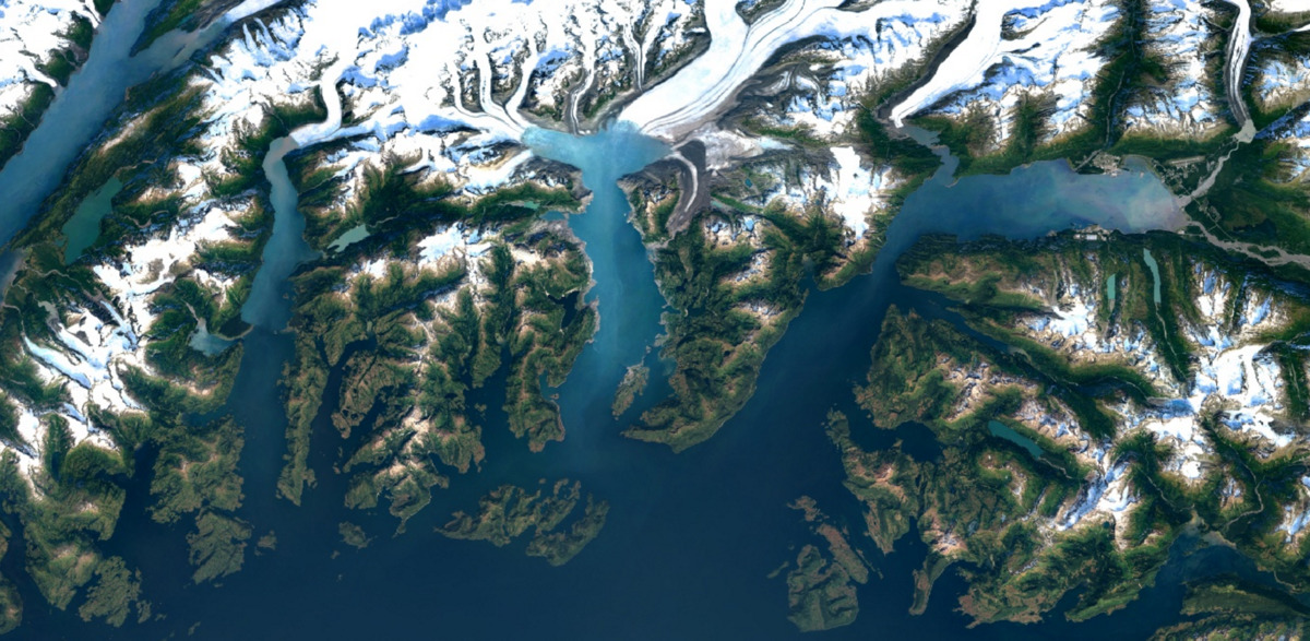
Columbia Glacier, Alaska
Detroit, Michigan
Swiss Alps, Switzerland
Higher Quality Imagery
Landsat 8
, which launched into orbit in 2013,
is the newest sensor in the USGS/NASA Landsat Program—superior to its predecessors in many ways. Landsat 8 captures images with greater detail, truer colors, and at an unprecedented frequency—capturing twice as many images as Landsat 7 does every day.
This new rendition of Earth uses the most recent data available -- mostly from Landsat 8 -- making it
our freshest global mosaic to date.
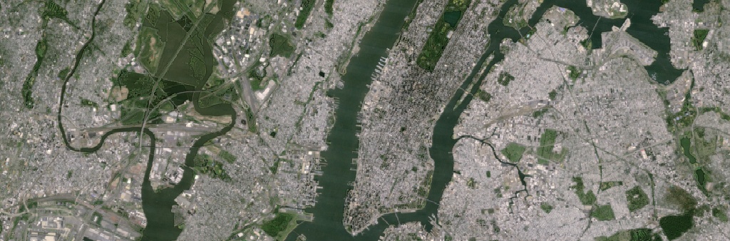
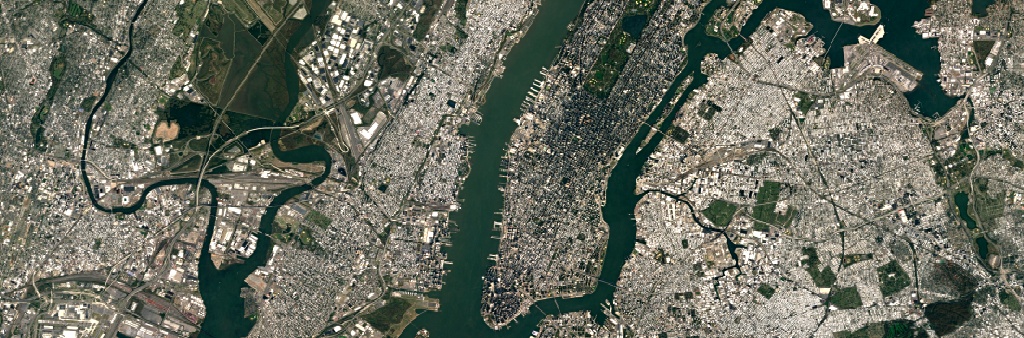
In the new view of New
York
City, details like skyscrapers, building shadows, and baseball and softball fields in Central Park shine through.
Our previous mosaic used imagery from Landsat 7 only, which at the time was the best imagery of its kind. Unfortunately, Landsat 7 images captured after 2003 were affected by a
hardware failure
, resulting in large diagonal gaps of missing data You can see this effect in the subsets of two Landsat 7 images captured over Oklahoma City, OK, in 2000 and 2003.
July 9, 2000
September 20, 2003
Processing imagery with Earth Engine
To produce this new imagery, we used the same publicly available Earth Engine APIs that scientists use to do things like
track global tree cover, loss, and gain
;
predict Malaria outbreaks
; and
map global surface water over a 30 year period
.
Like our previous mosaic, we mined data from nearly a petabyte of Landsat imagery—that’s more than 700 trillion individual pixels—to choose the best cloud-free pixels. To put that in perspective, 700 trillion pixels is 7,000 times more pixels than the estimated number of stars in the Milky Way Galaxy, or 70 times more pixels than the estimated number of galaxies in the Universe.
Lake Balkhash, Kazakhstan
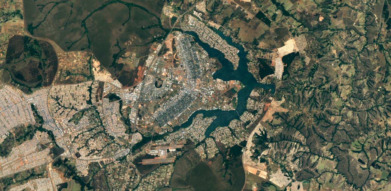
Brasilia, Brazil
Open data is good for everyone
This update was made possible in a large part thanks to the
Landsat
program and its commitment to free and accessible open data. Landsat, a joint program of the USGS and NASA, has observed the Earth continuously from 1972 to the present day and offers a wealth of information on the changes to the Earth's surface over time. And it's all available in Earth Engine!
The new imagery is now available across all our mapping products. To check it out, open up Google Earth
, or turn on the satellite layer
in Google Maps.
Post authored by: Chris Herwig, Program Manager, Google Earth Engine
Going #SolarforSolstice with Project Sunroof and the Sierra Club
June 20, 2016
Join us in celebrating the start of summer in the Northern Hemisphere—the longest and brightest day of the year, when the Northern Hemisphere is tilted towards the sun more than any other day. Among the many gifts that summer brings—longer days, warm walks, and late evening dinners—solar energy is a largely underutilized benefit.
The sun delivers more energy to Earth in one hour than civilization uses in a whole year. On this long Summer Solstice day, solar panels on your roof could generate enough energy to run your refrigerator for almost two weeks—that’s 50 percent more energy than the average day. Yet globally only about 1 percent of our energy comes from solar. So today, Project Sunroof teamed up with the Sierra Club to share some tips on how you can better use the sun to generate energy and protect our Earth.
Solar energy is one of the cleanest energy sources available, and the U.S. has abundant solar resources.
Project Sunroof
is our attempt to make going solar a little easier. Homeowners can search their property and get a solar recommendation based on roof size, the amount of sun that hits it throughout the year, weather, applicable government incentives, and electricity rates and bill.
Whether or not solar is an option for you, the
Sierra Club
has some additional tips on how to use the power of the sun and other forms of clean energy to slow the impacts of climate change. Check out
Ready for 100
to learn more about how you can help us achieve 100% clean, renewable energy across the United States.
Posted by Carl Elkin, Founder of Sunroof
Now you can use Explore to discover the flavors of Brazil
June 3, 2016
The countdown to the 2016 Rio Olympics is underway and the Google Maps team is making moves to ensure that Rio residents and Olympics tourists are able to navigate and explore the city. Whether you’re a Rio local looking to expand your palate beyond your favorite neighborhood restaurants or a traveler wanting to choose from all the restaurant options nearby, you can now look to Google Maps’ Explore feature for local suggestions when in Brazil.
The Explore experience in Brazil is very much like the experience here in the
US
and is available on both iPhone and Android. Simply open Google Maps on your mobile phone and tap “explore food & drinks near you” at the bottom of the screen. Depending on where you are and time of day, a category (breakfast, lunch, coffee, dinner and drinks) is preselected for you. Google Maps will share lists of food and drink locations around you, ranging from “best breakfasts” to “waterside dining”. Once you find a list that fits your needs, just tap on the list to see suggested locations. Then swipe right or left to see more options and tap “read more” or the arrow at the bottom of the screen to select a venue and get more details. Of course you'll see these on-screen prompts like "explore food & drinks near you" in the language you’ve set as primary on your mobile phone.
For those of you not heading to Rio this summer, you can still use Explore to discover new places around the world. Explore is also available on Android and iPhone in the US, UK, France, Germany, Italy, and Japan. And it was just recently made available in Australia and Canada as well.
Posted by Bryan Cheng, Product Manager, Google Maps
Take in the Sites of Rio de Janeiro Before the Games Begin
May 27, 2016
Preparations are underway in the “Marvelous City” in anticipation of the 2016 Olympics Games which is expected to draw an extra half a million people to Brazil this summer. The Google Street View team has also been busy preparing for the festivities. Over the past few months, we’ve capturing fresh imagery, so everyone can enjoy
the magic of Rio de Janeiro
– whether planning to attend in person or watch the excitement from afar.
Google Street View engineer takes pictures from the inside of Rio’s Olympic Park
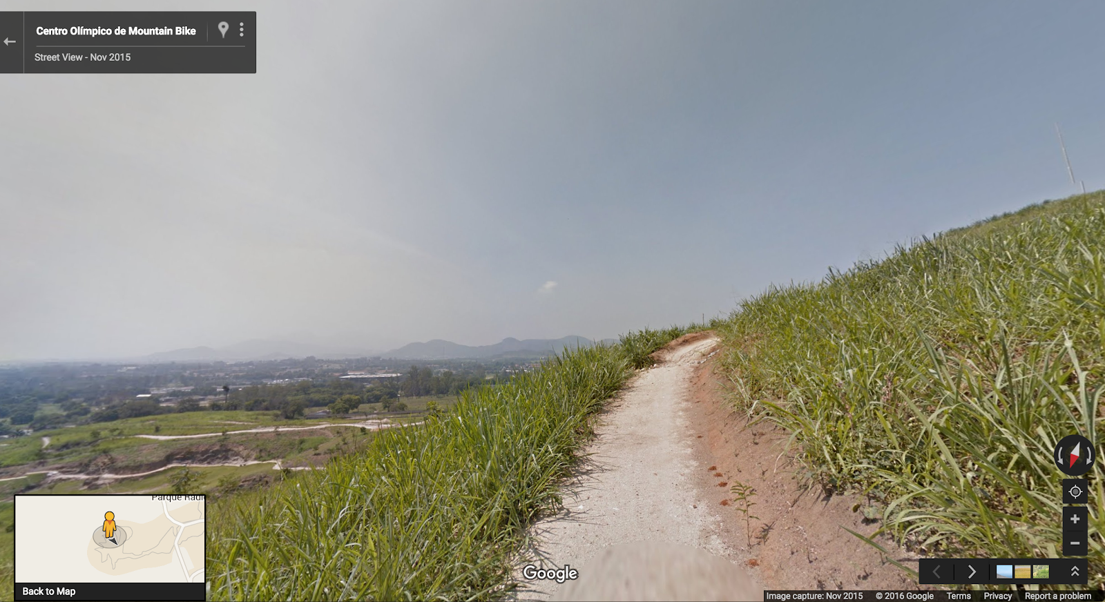
Starting today, a quick visit to Street View will give you a preview of the places where the world's most talented athletes will make history. Barrel down the Olympic
mountain bike trail
and take a stroll on
the track
where runners will sprint as fast as their legs will carry them in an attempt to bring home the gold.
Olympic Mountain Bike Trail
We’re also releasing indoor imagery of more than
200 hotels, restaurants and bars
across the city. Take a peek at the pink carpeted
Copacabana Palace
or the breathtaking poolside ocean views at the
Fasano Hotel
. If you’ll be in Rio for the Games, check out the vibe before you make restaurant reservations or the local bar to ensure there’s ample room on the dancefloor to bust out your Samba moves.
Suite in the Fasano Hotel, famous for its celebrity guests in Rio
Step outside to take in some of the most iconic sites of Rio including
Christ the Redeemer
, The
Dona Marta Hilltop
, and
Arpoador Beach
. We’ve captured imagery of every main tourist attraction in Rio including the famous
Selarón Steps
.
View from Arpoador Beach
In addition to the many beautiful sites, we’ve collected up-to-date Street View imagery of Rio's streets and neighborhoods so you can get a feel for the area around your accommodation ahead of time. Check out the bus stops to familiarize yourself with local transportation - or pick the perfect people watching Juice bar to enjoy an Acai bowl on the way from the hotel to the beach.
Whether you’re preparing to visit in person or simply enjoying the sites from afar, make yourself a caipirinha or have a Pão de Queijo (delicious Brazilian cheese bread) while you explore.
Posted by Marcus Leal, Google Maps manager in Brazil
Bring the world’s changing forests inside the classroom
May 25, 2016
Forests are the mighty lungs of our planet. They absorb carbon dioxide, and emit oxygen on which all people and animals on Earth rely. For the sake of our future, it is critical that all people, including the next generation, understand our global forests in order to manage them sustainably. Today,
Science in the Classroom
,
Dr. Matt Hansen
of the
University of Maryland
, and
Google Earth Engine
are presenting
Global Forest Change Explorer
to help engage young people in forest conservation.
Tracking patterns of change in a hotspot zone, Alaska.
The Global Forest Change Explorer website contains maps that are available for interactive analysis as well as an accompanying activity worksheet. The
Explorer Tool
allows students to quickly visualize trends in forest loss and gain, compare different countries and ecoregions, and apply the forest data to try to predict underlying causes where there is significant change in forest density. The Explorer Tool relies on open data that is used by remote sensing and GIS professionals in their work.
Fly to different parts of the world and compare data.
A number of years ago, Dr. Matt Hansen and a team of researchers at the University of Maryland turned to Google Earth Engine to map high-resolution global forest cover with Earth Engine's cloud-based image processing and computing. The team mapped global forest loss and gain from 2000 to 2012 at 30-meter resolution for the entire globe. In 2013, the methods and results were published in
Science Magazine
and online
for everyone to explore
. These findings are now an important part of the website
Global Forest Watch
, which gives governments and decision makers free access to the data and tools required to monitor and manage their forests.
Dr. Matt Hansen presenting at the World Economic Forum
Science in the Classroom (SitC) thought this was great research to bring into the classroom and make available to anyone online. SitC packages annotated research papers with supplemental teaching materials to help pre-college and college students understand the structure and workings of scientific research. SitC and Google Earth Engine built the Global Forest Change Explorer to make Dr. Hansen’s data accessible to a younger audience.
Annotations provide supplemental context to Dr. Hansen’s paper
We live in a dynamic world where the pressures of population growth increasingly impact and threaten our forests. However, as technology, open data, and people continue to mobilize, we are given more tools to research the health of our planet. Educators can easily flip their classrooms into science labs by combining
SitC materials
with Global Forest Change Explorer. With these tools, students will leave sessions with richer understanding of environmental change, more curiosity, and a desire to actively participate in protecting our forests.
Get started with Global Forest Change Explorer today!
Posted by Emily Henderson, Google Geo Education Outreach
Get away for Memorial Day with Google Maps’ road trip-friendly features and tips
May 19, 2016
It’s almost here. The first three-day weekend after the longest stretch of the year without a paid holiday—and the unofficial start of summer. With nearly 34 million people expected to hit the roads and travel more than 50 miles this Memorial Day weekend, travelers just might need some assistance getting where they’re going, beating the crowds and exploring once there. With Google Maps as your copilot you’ll have a leg up on the road tripping competition. Here are some Google Maps features and time-saving tips to help ace your long weekend road trip:
Searching within Navigation:
Make quick pit stops without long detours. Search for places along your route without ever leaving navigation mode. Once in navigation mode, just tap the magnifying glass and then tap a category like “gas stations” and see real-time gas prices or “restaurants” to see dining options close to you. Tap “search for more places” to search for a venue outside the preset categories. And no matter what you search for, you’re alerted to how much detour time the stop will add to your trip.
Available on iPhone and Android
Offline Maps:
Search for places, get directions, and turn-by-turn navigation even when you hit a dead zone. Before you leave and still have a wifi connection, just download the region you’ll be traveling within for an uninterrupted navigation experience once you hit the road.
Available on Android and iPhone
Real-time Traffic Alerts and Dynamic Rerouting:
Google Maps gives you the best and fastest route based on current and historic traffic conditions. When you Input a destination, you get alerted about upcoming traffic conditions. And while on the road, Google Maps gives you a heads up if congestion lies ahead along with an estimate of how long the delay will be. You’ll also get suggestions for an alternative route (if a faster one is available) with an explanation for why it’s recommended.
Available on Android and iPhone
Toll and Ferry Notifications:
Never get caught without exact change again. You’ll see a toll icon when your route includes toll roads and you’ll see a ferry icon if your route requires you to take a ferry. To avoid tolls and ferries completely, select “Route options” when you search for driving directions and check off the categories you want to avoid.
Available on Android and iPhone
Explore:
Once you get to your destination, open Google Maps and tap “Explore food & drinks near you” at the bottom of the screen. Based on the time of day, you’ll see relevant lists of food and drink locations nearby.
Available on Android and rolling out to iPhone users in the US, UK, Japan, France, Germany, Italy and Spain now
Now that you’ve got the scoop on road trip-friendly features, get familiar with some time-saving tips. Master these simple hacks and you’ll practically be a Google Maps ninja.
Shift into navigation mode faster:
You can access navigation mode in Maps (turn-by-turn directions and dictation) by tapping and holding the car, bike, or walk icon in the bottom right corner of your phone screen.
Available on Android and iPhone
Get oriented with one tap:
Tap the compass in the top right corner of your screen, and the map will shift to match the direction you’re facing.
Available on Android and iPhone
Try the one-handed zoom:
If you've only got one hand free, you can still zoom into your map—just double tap the screen and swipe up or down to zoom in and out.
Available on Android and iPhone
Quickly access Street View on the go:
On your phone, long press somewhere on the map to drop a pin, search for a place, or select a location already shown. Tap the bar at the bottom of the screen and then tap again on the image with the 360 degree arrow in the bottom left hand corner to enter Street View mode. To take a look around your destination just swipe around the Street View image.
Available on Android and iPhone
Posted by Amanda Leicht Moore, Google Maps Product Manager
Labels
#streetview
#treasuremap
+1
3D
8bitmaps
Adwords Express
Africa
Amazon
Andorra
Android
api
Art Project
Audi
biking
Boost
Boulder
Brazil
Bulgaria
Business Photos
Business View
businesses
Canada
check-in
community
competition
contest
crisis response
Culture
custom maps
developer
Developers
directions
disaster response
discovery
earth outreach
education
Emmy Awards
Enterprise
Estonia
Europe
Explore
Fusion Tables
gadgets
Gibraltar
GMM
google
Google Earth
Google Earth Engine
Google Map Maker
Google Maps
Google Maps API
Google Maps Engine
Google Maps for Mobile
Google Maps Gallery
Google Maps Navigation
Google Maps Transit
Google Places
Google Plus
Google Search
Google Street View
google.org
Google+
googlenew
Grand Canyon
ground truth
Halloween
historical
history
holiday
Hotpot
Hungary
imager
imagery
Indoor Maps
iOS
iPhone
Iraq
Japan
Latitude
Latvia
layers
LBC
Lithuania
London
Making of Maps
Malaysia
Mall of America
Map Maker
Maps Blog
Maps Gallery
mapsgl
Matt Harding
Mexico
Mobile
Monticello
My Maps
my places
my tracks
National Geographic
navigation
new Google Maps
oblique imagery
ocean
offline maps
Olympics
Outreach
Pakistan
Panoramio
Parks Canada
Pegman
Photo Spheres
photo tours
photos
picasa
Polar Bears
Quiz
real estate
restaurants
road trips
Russia
Santa
Santa Tracker
search stories
SketchUp
Slovakia
Slovenia
South Sudan
space
Spain
sports
Street View
summer
SXSW
Tags
Thomas Jefferson
Thomas Jefferson Foundation
Tip of the week
tips
tour guide
traffic
Train
Transit
travel
trees
Trekker
Trike
Trolley
U.S. National Park Service
Ukraine
University of Virginia
Valentine's Day
Veterans Day
Views
voice search
walking
Waze
weather
webgl
Your Timeline
zagat
Archive
2016
Sep
Aug
Jul
Jun
May
Apr
Mar
Feb
Jan
2015
Dec
Nov
Oct
Sep
Aug
Jul
Jun
May
Apr
Mar
Feb
Jan
2014
Dec
Nov
Oct
Sep
Aug
Jul
Jun
May
Apr
Mar
Feb
Jan
2013
Dec
Nov
Oct
Sep
Aug
Jul
Jun
May
Apr
Mar
Feb
Jan
2012
Dec
Nov
Oct
Sep
Aug
Jul
Jun
May
Apr
Mar
Feb
Jan
2011
Dec
Nov
Oct
Sep
Aug
Jul
Jun
May
Apr
Mar
Feb
Jan
2010
Dec
Nov
Oct
Sep
Aug
Jul
Jun
May
Apr
Mar
Feb
Jan
2009
Dec
Nov
Oct
Sep
Aug
Jul
Jun
May
Apr
Mar
Feb
Jan
2008
Dec
Nov
Oct
Sep
Aug
Jul
Jun
May
Apr
Mar
Feb
Jan
2007
Dec
Nov
Oct
Sep
Aug
Jul
Jun
May
Feed
Google
on
Follow @googlemaps
Follow
Give us feedback in our
Product Forums
.


 Follow