The official blog for Google Maps
See 3D buildings in a whole new way with Google MapsGL
April 26, 2012
In March, we shared news of a
significant improvement
over our previous 3D buildings in
Google Maps
, providing a much more recognizable view of thousands of important buildings around the world. Now, we’ve brought this enhanced 3D experience to
Google MapsGL
as well.
Google MapsGL is a true 3D experience affording a perspective called “
parallax
”, so you can get different views of a building depending on where you pan. Here are a few comparisons of this 3D upgrade for some landmarks around the world:
Here’s
Big Ben
before and after
the
Eiffel Tower
before and after
the
Piazza del Duomo
before and after
and the
Seattle Space Needle
before and after.
But those are just a few of the many improved 3D landmarks now available around the world. Along with our recent launch of
Google MapsGL photo tours
we hope you enjoy these more realistic perspectives and tours of buildings you might want to visit or see in your own neighborhoods!
Posted by Sean Egan, Software Engineer, Google Maps
New 45° imagery available for 19 cities
April 25, 2012
The latest 45° imagery update in Google Maps features new imagery for 8 international locations and 11 U.S. locations. This also marks the first time we're publishing 45° imagery for France.
Avignon, France
The city of Avignon is the first place in France where 45° imagery will be available. Classified as a world heritage site by UNESCO, Avignon is full of history. The famous bridge “le pont d’Avignon” (referenced in the well-known French song “Sur le pont d’Avignon”) provides a spectacular view of the old city, including the “Palais des Papes” where 7 popes have resided.
These days, the city is well known for the “festival d’Avignon”. Every summer, Avignon becomes a city-theater transforming its architectural heritage into venues to host a contemporary performing arts festival.
View Larger Map
Rotterdam, Netherlands
Starting as a dam constructed in 1270 on the Rotte River, Rotterdam has grown into a major international commercial center. Its strategic location at the Rhine-Meuse-Scheldt delta on the North Sea and at the heart of a massive rail, road, air and inland waterway distribution system extending throughout Europe is the reason that Rotterdam is often called the "Gateway to Europe".
View Larger Map
Miami, Florida
This imagery update also includes the southernmost 45° imagery in the United States so far: Miami, Florida. Besides its status as a popular tourist destination, there are several interesting tidbits about Miami. Since permanent weather recordings started in 1900, Miami has experienced snowfall only once. Moreover, the Port of Miami is also currently the world’s busiest in terms of passenger traffic and cruise lines.
View Larger Map
International:
Avignon, France; Reus, Spain; Rotterdam, Netherlands; L'Alcudia, Spain; Gandia, Spain; Sueca, Spain; Burgos, Spain; Los Palacios Y Villafranca, Spain
US:
Albany, GA; Omaha, NE; Baytown, TX; Miami, FL; Amarillo, TX; Monroe, LA; Manchester, NH; Alexandria, LA; Rapid City, SD; Loudon, TN; Farmington, NM
Happy exploring!
Posted by Gwen Cossoul, Maps for Business Technical Program Manager
Visit global landmarks with photo tours in Google Maps
April 25, 2012
Every year, millions of people pack their bags and head to far-off places to enjoy sites and cultures different from their own. While there, they snap photos to document their trip and share their excursions online. Yet none of these individual photos captures the experience of actually being immersed in a specific location. With today’s introduction of
photo tours
, a feature of Google Maps that guides you through a 3D photo scene, we're one step closer.
Photo tours are available for more than 15,000 popular sites around the world, from famous landmarks such as
St. Mark’s Basilica
in Italy to scenic treasures like
Half Dome in Yosemite
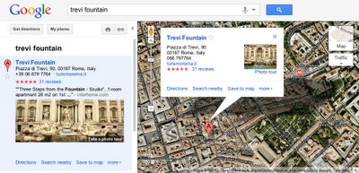
. They can be initiated from Google Maps in two ways. First, when you search for a place, such as
Trevi Fountain
, the results in the left panel will indicate if there is a photo tour available: click either the thumbnail image or the link to start the tour. Alternatively, if you’re browsing the map and click on the label for a particular landmark, the info window that appears will indicate if a photo tour is available.
To produce these photo tours, we use advanced computer vision techniques to create a 3D experience from public, user-contributed Picasa and Panaromio photos. We start by finding clusters of overlapping photos around major landmarks. From the photos, our system derives the 3D shape of each landmark and computes the location and orientation of each photo. Google Maps then selects a path through the best images, and adds 3D transitions to seamlessly guide you from photo to photo as if you’re literally flying around the landmark and viewing it from different perspectives.
Every photo is attributed to its contributor, and the more photos people share, the better the tours get. So if you have great photos of places you’ve visited on
Picasa
or
Panoramio
, make them public so they’ll be eligible for inclusion in these photo tours!
Please note that using photo tours requires
Google Maps with WebGL
. Check out a
few of our favorites
or
visit this map
to browse all the available tours. Enjoy touring!
Posted by Steve Seitz, Software Engineer, Google Maps
Street View comes to Ukraine
April 24, 2012
You can now visit the country of Ukraine through Street View in time for the
2012 European Football Championships
. Located in the geographical center of Europe, Ukraine has many fascinating sites to explore.
At more than 1500 years old, the capital Kyiv is the oldest city in Central and Eastern Europe. You can know take a virtual stroll around the historical center of the city refereed to as the ‘Cradle of Slavic civilization’, including the UNESCO World Heritage listed sites of
Kyiv-Pechersk Lavra
and
Saint Sophia Cathedral
.
Kyiv-Pechersk Lavra
You can also explore the
historical center of Lviv
, another UNESCO World Heritage Site. The city dates back to the 14th century and features the Ploshcha Rynok central square.
Lviv historical center
The Odessa National Opera and Ballet Theatre is also now available, where artists like
Tchaikovsky
,
Sergei Rachmaninoff
, Enrico Caruso,
Feodor Chaliapin
performed.
Odessa National Opera and Ballet Theatre
Freedom Square in Kharkiv is the largest square in Eastern Europe and is home to the Derzhprom buildings. Constructed during the Soviet era, the ‘Palace of Industry’ was the tallest structure in Europe for its time in 1928.
Derzhprom
Whether you are planning your visit for the European Football Championships in June 2012 or you simply want to explore our beautiful country, we hope you enjoy these special views of Ukraine. To learn more about Street View, visit
the gallery
.
Posted by Marina Tarasova, Communications Associate, Google Ukraine
Exploring Jerusalem’s Old City streets with Street View
April 22, 2012
Cross posted on the
Official Google Blog
Every year, 3.5 million people come to Israel to visit ancient sites that are holy to billions of people, to walk among the unique
stone
of Jerusalem, or to relax on the beaches of the Mediterranean.
Inside Jerusalem's Old City
To help you explore Israel’s history and present, we’ve launched imagery of Jerusalem, Tel Aviv-Jaffa and Haifa on Street View. You can explore the narrow streets of Jerusalem’s Old City and each of its four quarters, walk along the
Via Dolorosa
and see the
Church of the Holy Sepulchre
, visit the
Western Wall
and the
Mount of Olives
. You can stop by the
Biblical Zoo
, then visit the
Israel Museum
and the
Yad Vashem
Holocaust museum—and explore more with the
Art Project
and the Yad Vashem
photo archive
. Or you can stroll through Tel Aviv’s bohemian
Neve Tzedek
neighborhood and the
ancient port of Jaffa
, and take a virtual trip to some of Tel Aviv’s
scenic beaches
or to Haifa’s
Baha’i Gardens
.
We hope you’ll use Street View to discover, explore and more. Some are already using the new imagery to help others—for example,
Access Israel
, an organization working to make Israel more accessible for people with disabilities, has embedded Street View in its
accessibility mapping project
of Israeli cities (
note:
in Hebrew).
We’ll be adding more Street View coverage of sites and streets in the coming months, and are hoping to bring Street View to more places around the region soon. To see more, go to the
Street View gallery
.
Posted by Gadi Royz, Product Manager, Google Maps
Planting some green this Earth Day
April 22, 2012
Cross-posted from the
Official Google
and
Google Green
blogs
Since 1970, people all over the world have recognized April 22 as Earth Day, an opportunity to appreciate and generate awareness about the natural environment. Here at Google we strive to do
our part
to make sure our planet is healthy for years to come. From investing in renewable energy to building products that help people be greener in their own lives, we’re building a better web that’s better for the environment.
Today, we’re celebrating Earth Day in a variety of ways. The coming of spring inspired us to grow our annual Earth Day
doodle
right in our backyard. We planted seeds on a balcony at our Mountain View headquarters and watched them grow into what you see today. We’re also partnering with
Friends of the Urban Forest
to help make San Francisco schools a little greener.
To help you start a garden of your own, we’ve put together an
Earth Day resource page
. Explore community gardens and farmers’ markets on our
interactive map
,
get discounted seeds
to plant flowers, herbs, and vegetables in your own backyard and
connect with other gardeners
for planting tips and inspiration.
We hope you find these resources useful and enjoy gardening as much as we do. On our Mountain View, Calif. campus, we have community gardens where Googlers can grow and harvest their choice of herbs and vegetables. Company-wide, we focus on getting organic, locally-grown produce for our cafes. We purchase food directly from farms near our campuses, and learn about how our suppliers raise, farm, and harvest their food—all to ensure that we’re
eating sustainably
and being good to the environment.
We hope this Earth Day you are inspired to
add a little green
to the planet. Earth Day may only be a single day, but the actions we take can last for years to come.
Posted by Erin Reilly, Google Green Team
Imagery Update: Week of April 16th
April 20, 2012
The
Google Earth
and
Maps
Imagery team has published another batch of aerial and satellite imagery. In this post, we’ll look at newly released imagery that reflects the themes of past, present, and future.
2011: In the U.S., federal and state taxes were due this week as they are every year in mid-April for the previous year’s income. So in our first aerial example shown below, the structure on the left is the Sun Trust Bank Building, which houses the Internal Revenue Service’s Local Tax Assistant Center in Macon, Georgia. There, you can acquire previous tax returns and transcripts, as well as pay your Federal Tax bill; but keep in mind that exact change is required. On the right is the Macon City Auditorium and it’s famed copper dome, which is claimed by many locals to be the largest in the world.
Downtown Macon, Georgia
2012: Spring is here and that means the start of baseball season for the Chicago Cubs. A new season means another chance to win it all. Will this be the year? With motivated ownership, a newly hired proven General Manager and a revamped line-up, they’ve definitely got a shot (just like everybody else). One thing is for certain, as you can see in the aerial image below,
Wrigley Field
, home of the Chicago Cubs, is in game-winning shape!
Wrigley Field, Chicago, Illinois
2013: Baseball isn’t the only sporting event eagerly anticipated by fans. Next year marks the official kick-off (no pun intended) of the countdown to the 2014
FIFA World Cup
. These dress-rehearsal matches comprise the FIFA Confederations Cup and are held in 2013 by Brazil, host nation of the 2014 World Cup. The aerial image below shows the
Governor Magalhães Pinto Stadium
, under construction in preparation for the upcoming 2013 and 2014 matches.
Governor Magalhães Pinto Stadium, Belo Horizonte, Brazil
If you’d like to receive an email notification when the Google Earth and Maps Imagery team updates your favorite areas(s), we’ve got just the tool: The
Follow Your World
application!
These are only a few examples of the sites that can be seen and discovered in our latest batch of published imagery. Happy exploring!
High Resolution Aerial Updates:
USA: Aberdeen, SD; Amarillo, TX; Billings, MT; Bismark, ND; Cape Cod, MA; Chester, SC; Chicago, IL; Clemson, SC; Columbia, SC; Glasgow, MT; Havre, MT; Jamestown, ND; Lake of the Ozarks, MO; Long Island, NY; Macon, GA; Pierre, SD; Red Lake, MN; Sheridan, WY; Ulysses, KS; Wenatchee, WA
Avignon, France; Belo Horizonte, Brazil; Mar del Plata, Argentina
Countries/regions receiving high resolution satellite updates:
Afghanistan, Albania, Algeria, Angola, Antarctica, Argentina, Australia, Bangladesh, Benin, Bhutan, Bolivia, Botswana, Brazil, Bulgaria, Burkina Faso, Cambodia, Cameroon, Canada, Cape Verde, Chad, Chile, China, Cook Islands, Croatia, Cuba, Democratic Republic of the Congo, Djibouti, Dominican Republic, Ecuador, Egypt, Eritrea, Estonia, Ethiopia, Europa Island, Falkland Islands (Islas Malvinas), Fiji, Macedonia, France, Georgia, Greece, Guatemala, Guinea-Bissau, Hungary, India, Indonesia, Iran, Italy, Japan, Kenya, Kuwait, Lesotho, Libya, Madagascar, Malawi, Malaysia, Mali, Marshall Islands, Mauritania, Mauritius, Mexico, Morocco, Mozambique, Myanmar, Namibia, Nepal, New Zealand, Nicaragua, Niger, Nigeria, Oman, Pakistan, Palau, Panama, Papua New Guinea, Peru, Philippines, Poland, Qatar, Russia, Samoa, Saudi Arabia, Senegal, South Africa, Spain, Sri Lanka, Sudan, Swaziland, Tanzania, Thailand, Timor-Leste, Tunisia, Turkey, Uganda, United Arab Emirates, United States, Venezuela, Vietnam, Western Sahara, Yemen, Zambia, Zimbabwe
These updates are now available in both Google Maps and Google Earth. For a complete picture of where we updated imagery, download
this KML
for viewing in
Google Earth
.
Posted by Eric Kolb, Geo Data Strategist
Labels
#streetview
#treasuremap
+1
3D
8bitmaps
Adwords Express
Africa
Amazon
Andorra
Android
api
Art Project
Audi
biking
Boost
Boulder
Brazil
Bulgaria
Business Photos
Business View
businesses
Canada
check-in
community
competition
contest
crisis response
Culture
custom maps
developer
Developers
directions
disaster response
discovery
earth outreach
education
Emmy Awards
Enterprise
Estonia
Europe
Explore
Fusion Tables
gadgets
Gibraltar
GMM
google
Google Earth
Google Earth Engine
Google Map Maker
Google Maps
Google Maps API
Google Maps Engine
Google Maps for Mobile
Google Maps Gallery
Google Maps Navigation
Google Maps Transit
Google Places
Google Plus
Google Search
Google Street View
google.org
Google+
googlenew
Grand Canyon
ground truth
Halloween
historical
history
holiday
Hotpot
Hungary
imager
imagery
Indoor Maps
iOS
iPhone
Iraq
Japan
Latitude
Latvia
layers
LBC
Lithuania
London
Making of Maps
Malaysia
Mall of America
Map Maker
Maps Blog
Maps Gallery
mapsgl
Matt Harding
Mexico
Mobile
Monticello
My Maps
my places
my tracks
National Geographic
navigation
new Google Maps
oblique imagery
ocean
offline maps
Olympics
Outreach
Pakistan
Panoramio
Parks Canada
Pegman
Photo Spheres
photo tours
photos
picasa
Polar Bears
Quiz
real estate
restaurants
road trips
Russia
Santa
Santa Tracker
search stories
SketchUp
Slovakia
Slovenia
South Sudan
space
Spain
sports
Street View
summer
SXSW
Tags
Thomas Jefferson
Thomas Jefferson Foundation
Tip of the week
tips
tour guide
traffic
Train
Transit
travel
trees
Trekker
Trike
Trolley
U.S. National Park Service
Ukraine
University of Virginia
Valentine's Day
Veterans Day
Views
voice search
walking
Waze
weather
webgl
Your Timeline
zagat
Archive
2016
Sep
Aug
Jul
Jun
May
Apr
Mar
Feb
Jan
2015
Dec
Nov
Oct
Sep
Aug
Jul
Jun
May
Apr
Mar
Feb
Jan
2014
Dec
Nov
Oct
Sep
Aug
Jul
Jun
May
Apr
Mar
Feb
Jan
2013
Dec
Nov
Oct
Sep
Aug
Jul
Jun
May
Apr
Mar
Feb
Jan
2012
Dec
Nov
Oct
Sep
Aug
Jul
Jun
May
Apr
Mar
Feb
Jan
2011
Dec
Nov
Oct
Sep
Aug
Jul
Jun
May
Apr
Mar
Feb
Jan
2010
Dec
Nov
Oct
Sep
Aug
Jul
Jun
May
Apr
Mar
Feb
Jan
2009
Dec
Nov
Oct
Sep
Aug
Jul
Jun
May
Apr
Mar
Feb
Jan
2008
Dec
Nov
Oct
Sep
Aug
Jul
Jun
May
Apr
Mar
Feb
Jan
2007
Dec
Nov
Oct
Sep
Aug
Jul
Jun
May
Feed
Google
on
Follow @googlemaps
Follow
Give us feedback in our
Product Forums
.


 Follow