The official blog for Google Maps
Explore “land art” with Google Earth
August 2, 2011
Whether you’re an art lover or a
Google Earth
explorer (or both!), you’ll appreciate a new tour that highlights pieces from what’s known to be the
largest contemporary land art undertaking in the world
.
The
Rhythms of Life project
, by internationally renowned Australian sculptor
Andrew Rogers
, comprises 47 structures built over 13 years. The installations are found in 13 countries and were created with the help of 6,700 local people. Known as
geoglyphs
, these structures are built in exotic disparate locations including deserts, fjords, gorges, national parks and altiplano, with local materials by local people. They are so large they can be easily observed in Google Earth’s satellite imagery.
Andrew’s inspiration for this project was the interconnectedness of community and the environment, citing that the connected drawings on the surface of the Earth refer to the physical building blocks of history and civilization. He aims to establish communal structures for the purpose of ceremony and historical reflection with the local people.
The video below will take you on a tour of this project. You will discover land art in
Sri Lanka
,
China
,
Bolivia
, and
Iceland
. Andrew has also built sculptures more recently in
Antarctica
,
Kenya
, and
Turkey
and these pieces will be added to the tour in the future.
Tour video is also available at
andrewrogers.org
.
To view this tour in Google Earth, please download the
KML file
.
We hope you enjoy virtually visiting these art sculptures and are inspired by the beauty of the land and culture across the globe.
Posted by Karin Tuxen-Bettman, Google Earth Outreach
New 45° imagery available for 35 cities
August 2, 2011
This week we are expanding 45° imagery available in Google Maps to include many US cities, as well as some new international locales, such as Córdoba, Spain.
In Córdoba, the third largest town in the Spanish region of Andalucia, you can now explore in highly resolved images from four directions. Check out the world famous Mezquita-Catedral, a former mosque from the times when that part of Spain was ruled by the Moors, now a Roman Catholic Cathedral. Its construction as a mosque began around 800 and it was turned into a church after 1200.
View Larger Map
A major update in the U.S. comprises Houston, the largest city of Texas and fourth largest of the United States. Take a look at the Houston Ship Channel with all its refineries and oil tanks alongside, erected for one Million Dollars in 1902 when oil was first discovered in the area.
View Larger Map
If you like sports you’ll be interested in the Rice University’s athletics stadium west of downtown or the Toyota Center, used by the Houston Rockets basketball and the Houston Aeros hockey teams.
Or take a look at William P. Hobby Airport just southeast of the city center which was the former main hub even for international flights. Nearby the largest American flag can be seen on top of a building.
View Larger Map
Full list of updated cities:
Augsburg, Germany. Barstow, CA. Bartlett, TX. Big Bear, CA. Blackstone, VA. Catalina Foothills, AZ. Córdoba, Spain. Delano, CA. Desert Hot Springs, CA. Richmond, VA. Elgin, TX. Healdsburg, CA. Helendale, CA. Hemet, CA. Houston, TX. Mendoza, Argentina. Midlothian, VA. Napa Valley, CA. New Braunfels, TX. Ojai, CA. Ottawa, Canada. Pensacola, FL. Porterville, CA. Plant City, FL. Rancho Del Lago, AZ. Rosario, Argentina. Santa Clarita, CA. Sarasota, FL. Taylor, TX. Temecula, CA. Treasure Island, CA. Troy, IL. Twentynine Palms, CA. Wakefield, VA. Yucca Valley, CA.
Posted by Bernd Steinert, Geo Data Specialist
Catch the London Underground with Google Maps
July 28, 2011
(Cross-posted from the
Official Google Blog
)
Starting today, you can get
public transport directions
for London within Google Maps. One of Europe’s largest metropolitan areas, London is a major destination for both business travelers and tourists. More than
1 billion
passengers are serviced by Transport for London (TfL) every year across over 18,000 bus stops and over 250 Underground stations.
Let’s say you’re at Trafalgar Square, and you want to visit Madame Tussauds. With a
simple
directions search, you’ll see all the possible public transport connections. In
Maps
, click “Get directions” in the left-hand panel, and then the train icon to see public transport directions. Enter your departure location next to A, and your destination next to B. These can be either street addresses or names of popular places, businesses or restaurants. When you’re done, click the “Get directions” button and suggestions for your trip will appear below.
Public transport directions are available on both
Google Maps
and
Google Maps for mobile
, so you always have access to a trip planner. When you’re on mobile, Maps even uses your current location to determine the best trip to your destination. Just search for your destination location, select it on the map and choose the “Directions” option. The suggested trips will be based on your location by default, and provide you multiple alternatives whenever possible.
If you’re using an Android-powered device, you can also get public transport directions with
Transit Navigation (Beta)
in Google Maps. With this new feature, which we launched earlier this month, you’ll get alerts when it’s time to get off the bus or train at your destination or to make a transfer. Transit Navigation is available in all regions where public transport directions are available, including London.
TfL is among the first agencies in a major European city to make its timetable information
publicly available
through the London Datastore. We’re strong supporters of open data and bringing information out into the open, and believe that making information publicly accessible can be an enormous engine of economic growth and innovation.
ITO World
has been a great partner in this launch by ensuring TfL’s data was adapted correctly and ready for our use.
Public transport directions are available for all Underground, bus, tram and Docklands Light Railway (DLR) lines, and we’ll include more public transport information as soon as it’s available. Whether you use public transport every day or infrequently, as a commuter, on a business trip or as a tourist, we hope that public transport directions in London make planning your trips more convenient!
Posted by Thijs van As, Associate Product Manager, Transit Directions
Congratulations Russia, the National Geographic World Champions
July 27, 2011
(Cross posted on the
Official Google
and
Google Student
blogs)
This island has a population of about 57,000 people, with the most settlements concentrated on the west coast. Very little of this island is suitable for agriculture.
After eight rounds of questions from none other than quiz king
Alex Trebek
himself, the team from Russia was crowned the National Geographic World Champions today at our Mountain View, Calif. headquarters after answering this final question correctly.
(By the way, the answer is
Greenland
.)
The National Geographic World Champions from Russia (photo courtesy of National Geographic)
Students from 17 regions around the world competed in the
2011 National Geographic World Championship
. Today’s final round included answering a series of challenging questions like the one above. The students also interpreted maps and museum artifacts from the University of California Berkeley and fielded questions about live animals from the San Francisco Zoo during the
earlier rounds of the competition
.
Congratulations to the Russian team and to all of the students who participated. We look forward to seeing where your explorations and knowledge take you.
Posted by Brian McClendon, VP of Google Maps and Earth
Google Maps 5.8 for Android adds photo uploads, My Places, and more
July 27, 2011
Today,
Google Maps 5.8 for Android
improves
Places
and
Latitude
with:
Upload photos for a Place
My Places as a simple way to manage the Places you’ve starred and recently viewed
Descriptive terms for Places in search results
Add a new Place on-the-go when checking in
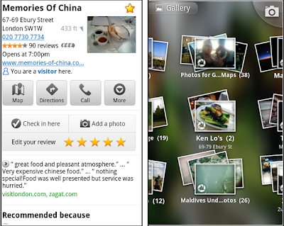
Photo upload for a Place
When deciding on a place to go, people often want to know what a place looks like in addition to seeing ratings and reviews. You can now contribute photos to help others get a sense of places. You can now attach your photos to Places, and yours may even become the profile picture for that page. If you want to view or delete any photos you’ve contributed to Places, you can manage uploaded photos in the “Photos for Google Maps” album on your
Picasa
account.
Left: Uploading pictures to a place. Right: Photos in Android Gallery
My Places and descriptive terms for mobile
In June we announced
descriptive terms
and
‘My Places’
for the desktop. Both these features are now in Google Maps for mobile. Descriptive terms appear in search results for Places to inform you what businesses are ‘known for,’ such as their ‘eggs benedict’ or being ‘worth the wait.’
Also, My Places for mobile provides quick access to starred and recent Place pages you’ve looked at. You can access My Places by pressing your phone’s menu button while in Google Maps.
Descriptive terms and My Places in Google Maps for mobile
Add a new Place ‘on-the-go’ for check-ins
If you’re out and about and want to check in, we want to make sure you can quickly add a new Place to check into if one isn’t available. This might happen for new businesses or those that haven’t set up a Place page yet. For example, let’s say you’re at Xoogle Xtreme Sports, a new sports shop in your neighborhood. You go to check in but don’t see Xoogle in the list of places to check into and when you do a search still nothing comes up.
Add a Place when checking in, if needed
To solve this, you’ll now see an “Add place” option at the bottom of suggested places. Select that option, and you’ll be prompted to confirm the name and location of the new place. Then a brand new place is added (and you’re checked in). This place will be available for you and others to check into from Latitude, but will not appear as a search result in Google Maps or Google Places.
We’ve also added ‘Bigger text’ to our
experimental Labs features
and ‘Download map area’ has been renamed ‘Pre-cache map area.’
To start using Google Maps 5.8 for Android, download the update
here
. This update requires an Android OS 2.1+ device and can be used anywhere Google Maps is currently available. Learn more in our
help center
.
Posted by Benjamin Grol, Product Manager
National Geographic World Championship comes to Google
July 26, 2011
(Cross posted on the
Official Google
and
Google Student
blogs)
It’s summer vacation for many kids, but 51 students from 17 different regions have been spending their time off polishing and fine-tuning their geographic skills to prepare for this year’s
National Geographic World Championship
, a biennial geography competition hosted by the
National Geographic Society
.
This year, Google is the proud sponsor and on Wednesday, July 27, we’ll host the three final teams from Canada, Chinese Taipei and Russia at our campus in Mountain View, California. The preliminary rounds included a written exam on Sunday and activities at the San Francisco Zoo on Monday morning. Teams ventured to various zoo exhibits and were asked to identify climate maps and geographic locations associated with 10 different animal habitats housed throughout the zoo.
Teams from Canada, Chinese Taipei and Russia will move on to the National Geographic World Championship
Since most of you can’t be here to witness the action in person, we’re going to live stream the finale, hosted by Alex Trebek of the game show JEOPARDY!. Tune into the
National Geographic YouTube Channel
Wednesday at 10:30 a.m. PDT to cheer on these young competitors from wherever you are in the world.
Through this competition, we aim to inspire the future generation of leaders and innovators to become more geographically literate and have a deeper understanding about the world they live in. We hope you are as excited as we are to see such enthusiasm and passion around geographic education.
Please join us in wishing all of these young geographic experts the best of luck!
Posted by Brian McClendon, VP, Google Earth and Maps
Explore new large geographic features in Google Earth
July 25, 2011
Since
announcing the "Mountains" layer
in April, we’ve been busy working to bring you additional geographic features in
Google Earth
. Today we’re announcing the availability of mountain ranges, deserts, plains and more under the “Borders and Labels” left Layers panel.
Along with well-known landmarks such as the Appalachian Mountains, the Alps and the Sahara Desert, you’ll also find some less-well-known (but just as interesting) features, including the
Lut Desert
in southeastern Iran (one of the hottest areas on Earth) and the
Canadian Shield
in central and eastern Canada (a very large area in where glaciers removed much of the topsoil starting around 4.5 billion years ago).
Lut Desert in southeastern Iran
Canadian Shield in central and eastern Canada
To view these and all the other newly-added features, make sure “Borders and Labels” box is checked in the left Layers panel in Google Earth and look for the green labels.
Knowing that a single label may not do justice to expansive areas such as the Rocky Mountains, we’ve also enabled “mouseover” extents for these geographic features. By simply moving your mouse over the label you can see the full extent of larger formations or regions.
Mouseover extent of the Rocky Mountains
We hope this addition makes it easier for you to explore the world’s greatest natural features.
Posted by Pete Giencke, GIS Data Engineer
Labels
#streetview
#treasuremap
+1
3D
8bitmaps
Adwords Express
Africa
Amazon
Andorra
Android
api
Art Project
Audi
biking
Boost
Boulder
Brazil
Bulgaria
Business Photos
Business View
businesses
Canada
check-in
community
competition
contest
crisis response
Culture
custom maps
developer
Developers
directions
disaster response
discovery
earth outreach
education
Emmy Awards
Enterprise
Estonia
Europe
Explore
Fusion Tables
gadgets
Gibraltar
GMM
google
Google Earth
Google Earth Engine
Google Map Maker
Google Maps
Google Maps API
Google Maps Engine
Google Maps for Mobile
Google Maps Gallery
Google Maps Navigation
Google Maps Transit
Google Places
Google Plus
Google Search
Google Street View
google.org
Google+
googlenew
Grand Canyon
ground truth
Halloween
historical
history
holiday
Hotpot
Hungary
imager
imagery
Indoor Maps
iOS
iPhone
Iraq
Japan
Latitude
Latvia
layers
LBC
Lithuania
London
Making of Maps
Malaysia
Mall of America
Map Maker
Maps Blog
Maps Gallery
mapsgl
Matt Harding
Mexico
Mobile
Monticello
My Maps
my places
my tracks
National Geographic
navigation
new Google Maps
oblique imagery
ocean
offline maps
Olympics
Outreach
Pakistan
Panoramio
Parks Canada
Pegman
Photo Spheres
photo tours
photos
picasa
Polar Bears
Quiz
real estate
restaurants
road trips
Russia
Santa
Santa Tracker
search stories
SketchUp
Slovakia
Slovenia
South Sudan
space
Spain
sports
Street View
summer
SXSW
Tags
Thomas Jefferson
Thomas Jefferson Foundation
Tip of the week
tips
tour guide
traffic
Train
Transit
travel
trees
Trekker
Trike
Trolley
U.S. National Park Service
Ukraine
University of Virginia
Valentine's Day
Veterans Day
Views
voice search
walking
Waze
weather
webgl
Your Timeline
zagat
Archive
2016
Sep
Aug
Jul
Jun
May
Apr
Mar
Feb
Jan
2015
Dec
Nov
Oct
Sep
Aug
Jul
Jun
May
Apr
Mar
Feb
Jan
2014
Dec
Nov
Oct
Sep
Aug
Jul
Jun
May
Apr
Mar
Feb
Jan
2013
Dec
Nov
Oct
Sep
Aug
Jul
Jun
May
Apr
Mar
Feb
Jan
2012
Dec
Nov
Oct
Sep
Aug
Jul
Jun
May
Apr
Mar
Feb
Jan
2011
Dec
Nov
Oct
Sep
Aug
Jul
Jun
May
Apr
Mar
Feb
Jan
2010
Dec
Nov
Oct
Sep
Aug
Jul
Jun
May
Apr
Mar
Feb
Jan
2009
Dec
Nov
Oct
Sep
Aug
Jul
Jun
May
Apr
Mar
Feb
Jan
2008
Dec
Nov
Oct
Sep
Aug
Jul
Jun
May
Apr
Mar
Feb
Jan
2007
Dec
Nov
Oct
Sep
Aug
Jul
Jun
May
Feed
Google
on
Follow @googlemaps
Follow
Give us feedback in our
Product Forums
.


 Follow