The official blog for Google Maps
A galaxy of your own
September 30, 2010
(Cross-posted with the
Official Google Blog
)
Last December, we
wrote about
our immersive Google Earth environment, Liquid Galaxy: eight 55-inch LCD screens showing Google Earth in a unified, surround view.
Liquid Galaxy at TED 2010
Since then, we’ve taken it to a lot of conferences, built Liquid Galaxies in Google offices all over the world and even put one in the
Tech Museum
in San Jose, Calif. We love watching people try it for the first time. Almost everybody wants to see their own house first; but then they start to explore, and we can never guess where they’ll choose to go next.
But we just couldn’t bring it to enough people—we could only go to so many conferences, and only friends and family of Googlers could try out the Liquid Galaxies in our offices.
So we decided to put the features that make Liquid Galaxy possible into the latest release of
Google Earth
, and open-source all the supporting work, from our Ubuntu
sysadmin scripts
to the
mechanical design
of our custom frames.
Not everyone will have the know-how to network computers together and get view synchronization working, but we tried to make it as easy as possible. If you think you’re up to the challenge, check out our
Quick Start
page. You can also contact our supplier
End Point
if you’d rather buy than build (or just need some professional assistance). Here’s a video they made that shows Liquid Galaxy in action:
Liquid Galaxies don’t have to be made from eight big LCD screens; the view sync features scale just fine from two to dozens of screens. And they
can run more than just Google Earth
; we’ve had success playing video in sync in our Liquid Galaxies, and even modified a Free Software video game for after-hours fun. We’ve daydreamed about making panoramic movies,
head tracking
or even real-time video from distant
panoramic cameras
. Read more on the
Liquid Galaxy page
at earth.google.com, and show off your creations in the
liquid-galaxy discussion group
. We’re excited to see what you come up with!
Posted by Jason Holt, Software Engineer, Liquid Galaxy 20% Team
Explore the world with Street View, now on all seven continents
September 30, 2010
[Cross-posted from the
Official Google Blog
]
Update
12:01PM:
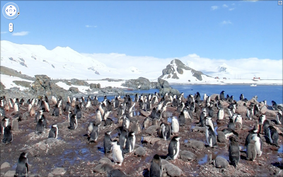
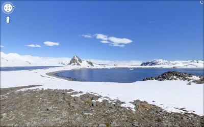
To clarify, the Street View imagery for Antarctica includes panoramas of an area called Half Moon Island – such as
this view of penguins
and
this one of the landscape
. The blue dots you see throughout the continent when dragging the pegman are
user-contributed photos
.
We
introduced
Street View back in May 2007, enabling people to explore street-level imagery in five U.S. cities. We were excited to share a virtual reflection of the real world to enable armchair exploration. Since then, we’ve expanded our 360-degree panoramic views to many more places, allowing you to check out a restaurant before dining there, to explore a neighborhood before moving there and to find landmarks along the route of your driving directions.
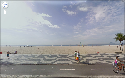
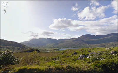
Three years later, we’re happy to announce that you can now explore Street View imagery on all seven continents, with the addition today of Brazil, Ireland and Antarctica. You can now see images from around the world spanning from the beaches of Brazil, to the moors of Ireland, to the icy terrain in Antarctica.
We often consider Street View to be the last zoom layer on the map, and a way to show you what a place looks like as if you were there in person—whether you’re checking out a coffee shop across town or planning a vacation across the globe. We hope this new imagery will help people in Ireland, Brazil, and even the penguins of Antarctica to navigate nearby, as well as enable people around the world to learn more about these areas.
For example, as summer winds down here in Mountain View, Calif., the famous beaches of Copacabana, Brazil are an enticing virtual travel destination.
The Ring of Kerry in Ireland, with its picturesque rolling landscape, is another favorite new place in Street View.
Speaking of travel, my wife BethEllyn and I embarked on the Minerva for an
expedition to Antarctica
in late January. We enjoyed stunning vistas, and I found that any minute not spent on deck was a
spectacular view
missed. Fortunately, we’d planned to take some Street View photos, and are now able to share with you the incredible visuals from Half Moon Island, Antarctica.
Here is a group of Chinstrap penguins we saw on the island.
And this is one of my favorite views. You can see part of the crescent shape that gives the island its name.
I’m very proud of the worldwide Street View team and thrilled that everyone can now see places from all seven continents, including the amazing landscapes and natural beauty I saw in Antarctica, through the street-level images in Google Maps and Google Earth. To see more highlights from Street View around the world, visit the
Street View gallery
and start exploring!
Posted by Brian McClendon, VP of Engineering, Google Earth and Maps
Google Map Maker and UNITAR Collaboration Shines at Shanghai World Expo
September 29, 2010
This past weekend at the
2010 World Expo
, UN Institute for Training and Research (
UNITAR
) and Google gave a joint presentation and informational session about their recent work together in global humanitarian mapping.
Illustrating his remarks with information about the
Pakistan 2010 flood relief efforts
, UNITAR Geospatial Analyst Josh Lyons explained how
Google Map Maker
helps his organization quickly and accurately produce geospatial products and emergency response maps. By leveraging the high quality, up-to-date information provided by users in Google Map Maker, UNITAR is able to produce and distribute helpful composite map products using tools such as UNITAR’S Operational Satellite Applications Programme (
UNOSAT
). These products played a key role in facilitating modern humanitarian relief for the recent disaster in Pakistan.
UNITAR/UNOSAT map for Pakistan flood analysis, with transport data from Google Map Maker
Dr. Carlos Lopes
, United Nations Assistant Secretary-General and Executive Director of UNITAR, expressed his excitement both to work with Google and that UNITAR/UNOSAT resources that had previously been spent on mapping data collection could now be invested directly into analysis. He remarked that users and beneficiaries aided by this collaborative effort include operational UN agencies, international NGOs and national entities from government and civil societies, and of course, the people directly affected by disasters and other crises.
We hope that the interest and increased awareness that the
Shanghai World Expo event
generated about
Google Map Maker
helps to build an even stronger user community. It’s the online mapping contributions of volunteers across the globe that enable Map Maker to be a valuable tool for humanitarian activities like this as well as a source of quality maps in the developing world. Let’s continue mapping the world together!
Posted by Andrea Fang Chu, Google Maps Software Engineer
Revamping the Photo Layer in Google Maps
September 28, 2010
Here at Google, we love the experience of browsing photos on a map, and today it just got a lot easier. We have launched an update to the design of the Photo layer in Google Maps to provide you with a better experience when browsing your favorite places:
There are three main improvements in this latest update:
Firstly, we have made improvements to the density of the photos on the map, making it easier to see clusters of photos in popular locations. On the screenshot above, you can now well see that there are a lot more photos taken on the coast than there are inland.
Secondly, we’ve made the small thumbnails partially transparent, making it easier to see the underlying map, and helping you to stay oriented. On the screenshot above, the city and neighborhood labels are now more legible.
Finally, we are showing more information when you hover over a photo. Now, you can see a large thumbnail and the title of each image, so you can get a fast preview of what any photo looks like.
We’d love to hear your thoughts on the new layer, so feel free to leave us your comments in the
Panoramio forum
.
Jonah Jones, User Experience Designer, Google Maps
Imagery Update - Week of September 20th
September 23, 2010
Our latest imagery update is now live and ready for your viewing pleasure. This time around we’ve included high-resolution imagery of locations from more than one hundred countries! Check out some of my favorites from our latest batch below:
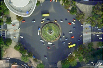
The Fountain of Diana the Huntress, one of the most representative sculptures of Mexican art, and main parade route location for the recent bicentennial celebration in Mexico City, Mexico.
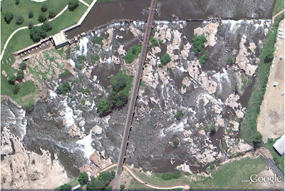
Sioux Falls, South Dakota
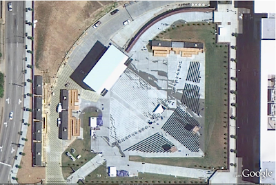
The recently completed Raleigh Convention Center and site of this weekend’s Mojo Musical Supply Southeastern Guitar & Amp Show in Raleigh, North Carolina. Turn it up to 11!
High Resolution Aerial Updates:
USA: Cincinnati, Denver, Greensboro, Raleigh, Miami, Monterey (CA), Portland (OR), San Diego, San Francisco, Sioux Falls (SD)
Mexico: Mexico City
Brazil: Rio De Jeaneiro
Sweden: Skara
Countries receiving High Resolution Satellite Updates:
Algeria, Angola, Argentina, Australia, Azerbaijan, Bangladesh, Benin, Bhutan, Bolivia, Botswana, Brazil, Brunei Darussalam, Burkina Faso, Burundi, Cambodia, Cameroon, Central African Republic, Chad, Chile, China, Colombia, Costa Rica, Cuba, Côte d'Ivoire, Democratic People's Republic of Korea, Democratic Republic of the Congo, Djibouti, Ecuador, Egypt, El Salvador, Eritrea, Ethiopia, Fiji, Former Yugoslav Republic of Macedonia, Gabon, Ghana, Guatemala, Guinea, Guyana, Haiti, Honduras, Hungary, India, Indonesia, Iran, Japan, Jordan, Kazakhstan, Kenya, Laos, Lesotho, Liberia, Libya, Madagascar, Malawi, Malaysia, Mali, Mexico, Mongolia, Morocco, Mozambique, Myanmar, Namibia, New Zealand, Nicaragua, Niger, Nigeria, Oman, Pakistan, Panama, Papua New Guinea, Paraguay, People's Republic of the Congo, Peru, Philippines, Russia, Rwanda, Saudi Arabia, Senegal, Serbia, Sierra Leone, Somalia, South Africa, Sri Lanka, Sudan, Suriname, Syria, Taiwan, Tajikistan, Tanzania, Thailand, Timor-Leste, Togo, Tunisia, Turkey, Turkmenistan, Uganda, United States, Uruguay, Uzbekistan, Venezuela, Vietnam, Yemen, Zambia, Zimbabwe
These updates are currently only available in Google Earth, but they'll also be in Google Maps soon. To get a complete picture of where we updated imagery, download
this KML
for viewing in
Google Earth
.
Posted by Eric Kolb, Geo Data Strategist
How to edit Google Maps and local business listing data
September 22, 2010
The world is a big place that’s constantly changing, so in digitally replicating it on Google Maps, you can imagine how much information we’re working with. We get data for Google Maps from a number of sources, including third party providers, business owners and users like yourself. And while for the most part, our algorithms do a great job of accurately reflecting the real world on the map, there are some instances when we get it wrong.
If you notice something that’s incorrect on Google Maps, chances are it’s either an issue with our map data - things like city and road names - or with our business listing data. We have a number of simple tools that make it easy for you to correct or report any issues so that we can get the maps right. Your assistance helps us provide the most accurate and up-to-date maps possible, so you and other Google Maps users can find what you’re looking for and be on your way.
Report a problem with our map data
Use the
Report a Problem
tool in the U.S. and Canada, most easily accessible by right-clicking on the map or clicking the link on the bottom right-hand-side of the map.
If anything with our map data is wrong, such as a road being renamed or a new highway on-ramp opening up, please submit a report. We work hard to fix the map based on user submissions, and try to resolve these issues as fast as we can.
Countries outside the U.S. and Canada should contact the Google Maps data provider to correct the information.
Edit business listing information directly on Maps
If you see incorrect information appearing on Google Maps listings in the U.S. (
and many more countries
), you can
make updates to listings
directly on Google Maps.
Once we've reviewed your edits, updates to the listing will go live within several hours.
If you are the business owner but have yet to claim your listing, see below for more information about Google Places.
Report incorrect business listing information
The best way to report incorrect information is to use the “Report a Problem” tool, where available.
Report a Problem
allows you to specify exactly what is incorrect about a listing.
Once these user-submitted reports are reviewed, updates to the listing will go live in a few weeks.
If you’re a business owner, you should also claim your
Google Places
listing so that you can edit and update the listing that appears on Google, Google Maps and GOOG-411. Verifying your free business listing allows you to not only ensure that accurate information appears on the
Place page
for your business, but also enhance your online presence by adding photos, videos and even real-time updates like weekly specials to your Place page.
Claim your Google Places listing
Claim your Google Places listing by adding it at
http://www.google.com/places
or by clicking “Business Owner?” on the Place page for your business.
Verify your listing by PIN (postcard or phone). Within an hour, click the “See your listing on Google Maps” link in your account to see your listing’s Place page.
If incorrect information is appearing in your listing, there are a
number of different ways to let us know
and get the information corrected.
Posted by Brianna Brekke, Senior Strategist, Google Places
Finding Places on the Web: Rich Snippets for Local Search
September 22, 2010
We’re sharing some news today that we hope webmasters will find exciting. As you know, we’re constantly working to organize the world’s information — be it textual, visual, geographic or any other type of useful data. From a local search perspective, part of this effort means looking for all the great web pages that reference a particular place. The Internet is teeming with useful information about local places and points of interest, and we do our best to deliver relevant search results that help shed light on locations all across the globe.
Today, we’re announcing that your use of
Rich Snippets
can help people find the web pages you’ve created that may reference a specific place or location. By using structured HTML formats like
hCard
to markup the
business or organization
described on your page, you make it easier for search engines like Google to properly classify your site, recognize and understand that its content is about a particular place, and make it discoverable to users on
Place pages
.
You can get started by reviewing these tips for using
Rich Snippets for Local Search
. Whether you’re creating a website for your own business, an article on a newly opened restaurant, or a guide to the best places in town, your precise markup helps associate your site with the search results for that particular place. Though this markup does not guarantee that your site will be shown in search results, we’re excited to expand support for making the web better organized around real world places.
Posted by Carter Maslan, Director of Product Management, Local Search
Labels
#streetview
#treasuremap
+1
3D
8bitmaps
Adwords Express
Africa
Amazon
Andorra
Android
api
Art Project
Audi
biking
Boost
Boulder
Brazil
Bulgaria
Business Photos
Business View
businesses
Canada
check-in
community
competition
contest
crisis response
Culture
custom maps
developer
Developers
directions
disaster response
discovery
earth outreach
education
Emmy Awards
Enterprise
Estonia
Europe
Explore
Fusion Tables
gadgets
Gibraltar
GMM
google
Google Earth
Google Earth Engine
Google Map Maker
Google Maps
Google Maps API
Google Maps Engine
Google Maps for Mobile
Google Maps Gallery
Google Maps Navigation
Google Maps Transit
Google Places
Google Plus
Google Search
Google Street View
google.org
Google+
googlenew
Grand Canyon
ground truth
Halloween
historical
history
holiday
Hotpot
Hungary
imager
imagery
Indoor Maps
iOS
iPhone
Iraq
Japan
Latitude
Latvia
layers
LBC
Lithuania
London
Making of Maps
Malaysia
Mall of America
Map Maker
Maps Blog
Maps Gallery
mapsgl
Matt Harding
Mexico
Mobile
Monticello
My Maps
my places
my tracks
National Geographic
navigation
new Google Maps
oblique imagery
ocean
offline maps
Olympics
Outreach
Pakistan
Panoramio
Parks Canada
Pegman
Photo Spheres
photo tours
photos
picasa
Polar Bears
Quiz
real estate
restaurants
road trips
Russia
Santa
Santa Tracker
search stories
SketchUp
Slovakia
Slovenia
South Sudan
space
Spain
sports
Street View
summer
SXSW
Tags
Thomas Jefferson
Thomas Jefferson Foundation
Tip of the week
tips
tour guide
traffic
Train
Transit
travel
trees
Trekker
Trike
Trolley
U.S. National Park Service
Ukraine
University of Virginia
Valentine's Day
Veterans Day
Views
voice search
walking
Waze
weather
webgl
Your Timeline
zagat
Archive
2016
Sep
Aug
Jul
Jun
May
Apr
Mar
Feb
Jan
2015
Dec
Nov
Oct
Sep
Aug
Jul
Jun
May
Apr
Mar
Feb
Jan
2014
Dec
Nov
Oct
Sep
Aug
Jul
Jun
May
Apr
Mar
Feb
Jan
2013
Dec
Nov
Oct
Sep
Aug
Jul
Jun
May
Apr
Mar
Feb
Jan
2012
Dec
Nov
Oct
Sep
Aug
Jul
Jun
May
Apr
Mar
Feb
Jan
2011
Dec
Nov
Oct
Sep
Aug
Jul
Jun
May
Apr
Mar
Feb
Jan
2010
Dec
Nov
Oct
Sep
Aug
Jul
Jun
May
Apr
Mar
Feb
Jan
2009
Dec
Nov
Oct
Sep
Aug
Jul
Jun
May
Apr
Mar
Feb
Jan
2008
Dec
Nov
Oct
Sep
Aug
Jul
Jun
May
Apr
Mar
Feb
Jan
2007
Dec
Nov
Oct
Sep
Aug
Jul
Jun
May
Feed
Google
on
Follow @googlemaps
Follow
Give us feedback in our
Product Forums
.






 Follow
