The official blog for Google Maps
Bring the world’s changing forests inside the classroom
May 25, 2016
Forests are the mighty lungs of our planet. They absorb carbon dioxide, and emit oxygen on which all people and animals on Earth rely. For the sake of our future, it is critical that all people, including the next generation, understand our global forests in order to manage them sustainably. Today,
Science in the Classroom
,
Dr. Matt Hansen
of the
University of Maryland
, and
Google Earth Engine
are presenting
Global Forest Change Explorer
to help engage young people in forest conservation.
Tracking patterns of change in a hotspot zone, Alaska.
The Global Forest Change Explorer website contains maps that are available for interactive analysis as well as an accompanying activity worksheet. The
Explorer Tool
allows students to quickly visualize trends in forest loss and gain, compare different countries and ecoregions, and apply the forest data to try to predict underlying causes where there is significant change in forest density. The Explorer Tool relies on open data that is used by remote sensing and GIS professionals in their work.
Fly to different parts of the world and compare data.
A number of years ago, Dr. Matt Hansen and a team of researchers at the University of Maryland turned to Google Earth Engine to map high-resolution global forest cover with Earth Engine's cloud-based image processing and computing. The team mapped global forest loss and gain from 2000 to 2012 at 30-meter resolution for the entire globe. In 2013, the methods and results were published in
Science Magazine
and online
for everyone to explore
. These findings are now an important part of the website
Global Forest Watch
, which gives governments and decision makers free access to the data and tools required to monitor and manage their forests.
Dr. Matt Hansen presenting at the World Economic Forum
Science in the Classroom (SitC) thought this was great research to bring into the classroom and make available to anyone online. SitC packages annotated research papers with supplemental teaching materials to help pre-college and college students understand the structure and workings of scientific research. SitC and Google Earth Engine built the Global Forest Change Explorer to make Dr. Hansen’s data accessible to a younger audience.
Annotations provide supplemental context to Dr. Hansen’s paper
We live in a dynamic world where the pressures of population growth increasingly impact and threaten our forests. However, as technology, open data, and people continue to mobilize, we are given more tools to research the health of our planet. Educators can easily flip their classrooms into science labs by combining
SitC materials
with Global Forest Change Explorer. With these tools, students will leave sessions with richer understanding of environmental change, more curiosity, and a desire to actively participate in protecting our forests.
Get started with Global Forest Change Explorer today!
Posted by Emily Henderson, Google Geo Education Outreach
Get away for Memorial Day with Google Maps’ road trip-friendly features and tips
May 19, 2016
It’s almost here. The first three-day weekend after the longest stretch of the year without a paid holiday—and the unofficial start of summer. With nearly 34 million people expected to hit the roads and travel more than 50 miles this Memorial Day weekend, travelers just might need some assistance getting where they’re going, beating the crowds and exploring once there. With Google Maps as your copilot you’ll have a leg up on the road tripping competition. Here are some Google Maps features and time-saving tips to help ace your long weekend road trip:
Searching within Navigation:
Make quick pit stops without long detours. Search for places along your route without ever leaving navigation mode. Once in navigation mode, just tap the magnifying glass and then tap a category like “gas stations” and see real-time gas prices or “restaurants” to see dining options close to you. Tap “search for more places” to search for a venue outside the preset categories. And no matter what you search for, you’re alerted to how much detour time the stop will add to your trip.
Available on iPhone and Android
Offline Maps:
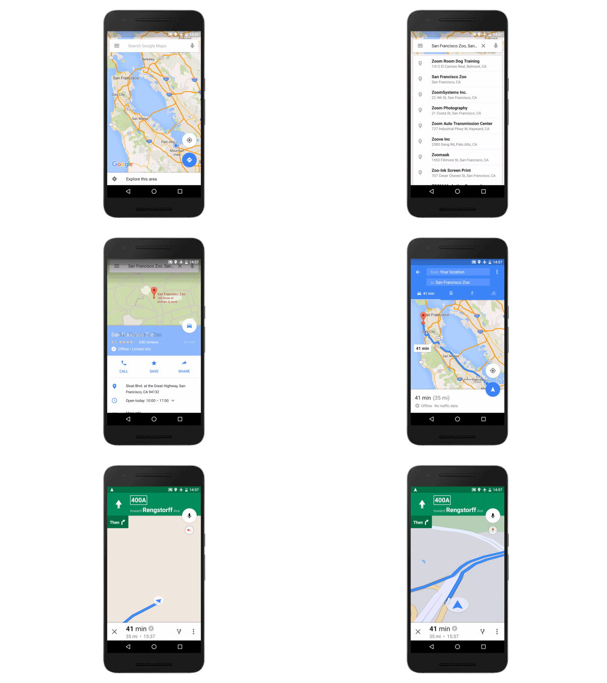
Search for places, get directions, and turn-by-turn navigation even when you hit a dead zone. Before you leave and still have a wifi connection, just download the region you’ll be traveling within for an uninterrupted navigation experience once you hit the road.
Available on Android and iPhone
Real-time Traffic Alerts and Dynamic Rerouting:
Google Maps gives you the best and fastest route based on current and historic traffic conditions. When you Input a destination, you get alerted about upcoming traffic conditions. And while on the road, Google Maps gives you a heads up if congestion lies ahead along with an estimate of how long the delay will be. You’ll also get suggestions for an alternative route (if a faster one is available) with an explanation for why it’s recommended.
Available on Android and iPhone
Toll and Ferry Notifications:
Never get caught without exact change again. You’ll see a toll icon when your route includes toll roads and you’ll see a ferry icon if your route requires you to take a ferry. To avoid tolls and ferries completely, select “Route options” when you search for driving directions and check off the categories you want to avoid.
Available on Android and iPhone
Explore:
Once you get to your destination, open Google Maps and tap “Explore food & drinks near you” at the bottom of the screen. Based on the time of day, you’ll see relevant lists of food and drink locations nearby.
Available on Android and rolling out to iPhone users in the US, UK, Japan, France, Germany, Italy and Spain now
Now that you’ve got the scoop on road trip-friendly features, get familiar with some time-saving tips. Master these simple hacks and you’ll practically be a Google Maps ninja.
Shift into navigation mode faster:
You can access navigation mode in Maps (turn-by-turn directions and dictation) by tapping and holding the car, bike, or walk icon in the bottom right corner of your phone screen.
Available on Android and iPhone
Get oriented with one tap:
Tap the compass in the top right corner of your screen, and the map will shift to match the direction you’re facing.
Available on Android and iPhone
Try the one-handed zoom:
If you've only got one hand free, you can still zoom into your map—just double tap the screen and swipe up or down to zoom in and out.
Available on Android and iPhone
Quickly access Street View on the go:
On your phone, long press somewhere on the map to drop a pin, search for a place, or select a location already shown. Tap the bar at the bottom of the screen and then tap again on the image with the 360 degree arrow in the bottom left hand corner to enter Street View mode. To take a look around your destination just swipe around the Street View image.
Available on Android and iPhone
Posted by Amanda Leicht Moore, Google Maps Product Manager
Your trip to Argentina awaits in Street View
May 9, 2016
Have you ever wondered what it’s like to side across a glacier? Or how it feels to stretch your arms beneath a waterfall? Well, now you can see for yourself. In its more than 2.7 million square kilometers, Argentina is home of some of the most spectacular natural settings on the globe. Starting today in Street View, you can experience a selection of
Argentina’s most breathtaking national parks
right from your Google Maps app for
Android
or
iOS
.
Standing at the foot of breathtaking falls in the
Parque Nacional Iguazú
, you can almost feel the mist swirling around you. Not to be missed, the Iguazú waterfalls are one of the
New7Wonders of Nature
.
Parque Nacional Iguazú - Isla San Martin, Argentina
No trip to Argentina is complete without gazing at the glorious
Perito Moreno Glacier
in the Los Glaciares National Park. The ice is 30 km in length and is one of 48 glaciers fed by the Southern Patagonian Ice Field—the world's third largest reserve of fresh water.
Parque Nacional Los Glaciares - Perito Moreno, Argentina
This is only the tip of the iceberg (or should we say glacier?). Experience even more of Argentina in Street View in Google Maps in our
Street View Gallery
.
Posted by Maite Iturria Arrospide, Program Manager for Google Maps
Get around Rio with indoor maps of 2016 Olympic venues
May 3, 2016
More than 10,000 athletes, half a million travelers and tens of thousands of volunteers are expected to join the roughly 6 million residents of Rio de Janeiro this summer for the 2016 Olympic Games. Over the next few months we’re making a variety of updates and additions to Google Maps to ensure Rio residents and visitors alike can easily get around once the torch is in town.
A few weeks ago we launched real-time transit in Rio de Janeiro. Now for the first time ever, you’ll be able to see indoor maps for 25 official indoor venues and enhanced outdoor maps of 12 official outdoor venues of the upcoming Olympic Games on Google Maps for desktop, Android and iOS.
Using indoor maps is easy. Just open Google Maps on your computer or mobile phone, search for a place that has indoor maps, zoom into the place, and click on it. At the bottom right side of the screen, choose among the floors and levels of the building. Points of interest like concessions, restrooms, information desks, and ATM machines are highlighted for easy identification.
Whether planning to attend the Games or just daydreaming about an Olympic getaway, you can view indoor maps of the venues on Google Maps. Here’s a sneak peek:
The opening ceremony will kick off the Games at the iconic
Maracanã
, where matches for one of the most popular events will take place—fútbol.
The new
Future Arena
will house handball games. Eventually, it will be taken apart and repurposed to build four public schools.
Golf is back at the Olympics after a 112-year hiatus. The competition will take place at the custom made 18-hole
Olympic Golf Course
.
Not heading to the Olympics? Don’t worry. With more than 3 billion square feet of indoor maps
globally
, Google Maps can help you get around the venues you're visiting this summer—whether you're cheering on the athletes in Rio, or closer to home.
Posted by Marcus Leal, Google Maps Product Manager, Latin America
A Street View salute to travel and tourism in the US
May 3, 2016
To celebrate
National Travel and Tourism Week
, Google Maps is releasing some new scenic Street View sights across the US collected with our partners in the
Trekker Loan Program
. In anticipation of the warm summer months ahead, discover and explore botanical gardens tours, historic boardwalks cruises and stunning city views all in your Google Maps app for
Android
and
iOS
.
Beginning our tour in Texas, working with our partners at the
Austin Convention and Visitors Bureau
, you can take a summer dip in the pristine
Hamilton Pool
, a popular swimming hole for tourists and residents alike. Heading west to El Paso with our partners at
Visit El Paso
, you can take a breathtaking walk through
Hueco Tanks State Park
, where rock climbers and hikers delight in the winding trails through canyons filled with unique bird species and botanicals. And for those in Houston, a stroll through
Hermann Park
thanks to
Houston Parks Board
, provides a scenic getaway in the heart of the city where visitors can enjoy a bit of recreation and relaxation.
Hamilton Pool, Austin, Texas
Heading east, you’ll find Mississippi's scenic summer offerings from our partners at
Visit Mississippi Gulf Coast
. First you can enjoy the natural beauty of the
Mississippi Sandhill Crane National Wildlife Refuge
, where the endangered
sandhill cranes
hail during their migration patterns. You can also enjoy the afternoon sun at the
Pascagoula Beach Park and Recreation Area
.
Mississippi Sandhill Crane National Wildlife Refuge
End your tour in the northwest, where national parks are plentiful and the natural views will leave you breathless. In Oregon, with our partners at
Travel Lane County
, you can see the
Heceta Head Lighthouse
, the most photographed lighthouse on the West Coast. Then see if you can uncover the winding trail to
Salt Creek Falls
, Oregon’s second tallest waterfall.
Heceta Head Lighthouse, Oregon
America’s unique history and beauty make it a great destination. To see more sites, explore our
U.S. Highlights Gallery
.
Posted by Posted by Susan Cadrecha, Google Maps Communications Manager
Sydney Opera House sets sail on Street View
April 26, 2016
Perched on Bennelong Point in Sydney Harbour, the Sydney Opera House is an Australian icon. Visited
by millions of people
each year, this architectural masterpiece can now be explored right from your Android or iPhone in Google Maps with the launch of the
Sydney Opera House on Street View
.
With this new collection, you can stand on the steps of the Opera House and
gaze at the white sails
, look out at
Sydney’s Harbour Bridge
, or take in the hustle and bustle of
Circular Quay
in 360-degree panoramic imagery from wherever you are.
Feel what it’s like to stand on the stage of the
Concert Hall
and look up at the
acoustic clouds
.
And go behind-the-scenes to spaces rarely seen by the public, like the stage of the
Joan Sutherland Theatre
.
Or see the
impressive tapestry
designed by the Sydney Opera House’s architect Jørn Utzon, which hangs in the room now named after him and overlooking Sydney Harbour.
Today’s new Street View collection is part of the opening of the
Sydney Opera House on the Google Cultural Institute
. To access this imagery, search for Sydney Opera House in Google Maps for mobile (available for both
Android
and
iOS
), and select the Street View option to enter your own 360-degree tour. We hope you enjoy exploring this Heritage listed site with Street View.
Posted by Cynthia Wei, Street View Program Manager Asia Pacific
How technology can help us become more sustainable
April 14, 2016
We want to create technology that helps millions of others
understand our changing world
and live more sustainably—whether it’s connecting people with public transit routes, or using the data that powers Google Earth to help you see if your roof is good for solar panels. In honor of Earth Day this month, we’ve gathered together some of the ways Google can help you reduce your everyday emissions and learn more about preserving our world.
Monitoring forests and wildlife
Google Earth satellite technology gives scientists and environmentalists a way to measure and visualize changes of the world on both land and water. This technology can have great impact on monitoring endangered animal populations around the world. For example, with the help of
Global Forest Watch
, powered by
Google Earth Engine
, scientists at the University of Minnesota are suggesting that
wild tiger populations may rebound by 2022
, due to the efforts to restore tiger habitats in key regions.
Anyone can now view tiger conservation areas (in orange and yellow above) using Global Forest Watch
Going solar
Looking to generate clean energy savings with solar power on your home? Check out
Project Sunroof
, a solar calculator that estimates the impact and potential savings of installing solar on the roof of your home. Taking Google Earth imagery and overlaying annual sun exposure and weather patterns, Sunroof is able to assess viable roof space for solar panel installation, estimate the value of solar and savings based on local energy costs, and connect you with providers of solar panels in your area.
As of this week, Sunroof expanded to 42 states across the U.S. (from
10 states in December
), which makes imagery and data available for a solar analysis to 43 million rooftops. We’re also working with organizations like Sierra Club and their
Ready for 100 campaign
to help analyze the solar potential of cities across the US.
Project Sunroof shows you the solar potential of your home and city, allowing you to realize its renewable potential. The image on the right shows how much sunshine Denver, CO residents can capture with solar.
Measuring air pollutants
For the past few years,
Google Earth Outreach
and the
Environmental Defense Fund
(EDF) have been working together to map methane leaks from natural gas pipelines under our streets. Since methane is a very potent greenhouse gas (GHG), even small leaks can add up to big emissions that can hurt our climate. By attaching methane analyzers to select Street View cars, we’ve driven more than 7,500 miles and have
mapped 4,200+ leaks in 10 cities
. What we found ranges from an average of one leak per mile (in Boston) to one leak every 200 miles (in Indianapolis), demonstrating the effectiveness of techniques like using plastic piping instead of steel for pipeline construction. We hope utilities can use this data to prioritize the replacement of gas mains and service lines (like New Jersey’s
PSE&G announced
last fall). We’re also partnering with
Aclima
to measure
many more pollutants
with Street View cars in California communities through this year.
Anyone can explore the maps at www.edf.org/methanemaps
Technology is crucial to increasing energy efficiency, raising climate change awareness, and sustainability efforts. To learn more about what you can do to help, take a moment to explore our
Google Earth Outreach
site, where these tools and more are described in depth.
Posted by Rebecca Moore, Engineering Director, Google Earth, Earth Engine & Outreach
Labels
#streetview
#treasuremap
+1
3D
8bitmaps
Adwords Express
Africa
Amazon
Andorra
Android
api
Art Project
Audi
biking
Boost
Boulder
Brazil
Bulgaria
Business Photos
Business View
businesses
Canada
check-in
community
competition
contest
crisis response
Culture
custom maps
developer
Developers
directions
disaster response
discovery
earth outreach
education
Emmy Awards
Enterprise
Estonia
Europe
Explore
Fusion Tables
gadgets
Gibraltar
GMM
google
Google Earth
Google Earth Engine
Google Map Maker
Google Maps
Google Maps API
Google Maps Engine
Google Maps for Mobile
Google Maps Gallery
Google Maps Navigation
Google Maps Transit
Google Places
Google Plus
Google Search
Google Street View
google.org
Google+
googlenew
Grand Canyon
ground truth
Halloween
historical
history
holiday
Hotpot
Hungary
imager
imagery
Indoor Maps
iOS
iPhone
Iraq
Japan
Latitude
Latvia
layers
LBC
Lithuania
London
Making of Maps
Malaysia
Mall of America
Map Maker
Maps Blog
Maps Gallery
mapsgl
Matt Harding
Mexico
Mobile
Monticello
My Maps
my places
my tracks
National Geographic
navigation
new Google Maps
oblique imagery
ocean
offline maps
Olympics
Outreach
Pakistan
Panoramio
Parks Canada
Pegman
Photo Spheres
photo tours
photos
picasa
Polar Bears
Quiz
real estate
restaurants
road trips
Russia
Santa
Santa Tracker
search stories
SketchUp
Slovakia
Slovenia
South Sudan
space
Spain
sports
Street View
summer
SXSW
Tags
Thomas Jefferson
Thomas Jefferson Foundation
Tip of the week
tips
tour guide
traffic
Train
Transit
travel
trees
Trekker
Trike
Trolley
U.S. National Park Service
Ukraine
University of Virginia
Valentine's Day
Veterans Day
Views
voice search
walking
Waze
weather
webgl
Your Timeline
zagat
Archive
2016
Sep
Aug
Jul
Jun
May
Apr
Mar
Feb
Jan
2015
Dec
Nov
Oct
Sep
Aug
Jul
Jun
May
Apr
Mar
Feb
Jan
2014
Dec
Nov
Oct
Sep
Aug
Jul
Jun
May
Apr
Mar
Feb
Jan
2013
Dec
Nov
Oct
Sep
Aug
Jul
Jun
May
Apr
Mar
Feb
Jan
2012
Dec
Nov
Oct
Sep
Aug
Jul
Jun
May
Apr
Mar
Feb
Jan
2011
Dec
Nov
Oct
Sep
Aug
Jul
Jun
May
Apr
Mar
Feb
Jan
2010
Dec
Nov
Oct
Sep
Aug
Jul
Jun
May
Apr
Mar
Feb
Jan
2009
Dec
Nov
Oct
Sep
Aug
Jul
Jun
May
Apr
Mar
Feb
Jan
2008
Dec
Nov
Oct
Sep
Aug
Jul
Jun
May
Apr
Mar
Feb
Jan
2007
Dec
Nov
Oct
Sep
Aug
Jul
Jun
May
Feed
Google
on
Follow @googlemaps
Follow
Give us feedback in our
Product Forums
.




 Follow
