The official blog for Google Maps
Making of Maps: Perspective from the ground
September 8, 2014
Our third post in the
Making of Maps
series
focuses on two individuals who have made significant contributions to their community’s information on Google Maps. Note: this interview has been edited for clarity and brevity. — Ed.
Google Map Maker
can give you the tools you need to improve information about your region in Google Maps—whether you’re adding a new road to your town, or getting your entire country on the map. Across the world, mappers have taken the lead on adding what’s most important to them—indigenous communities in Canada have
added reservations
; Detroit’s cycling enthusiasts have
improved the city’s biking lanes and trails
; and disaster response volunteers
dramatically improved
the map of the Philippines following
Super Typhoon Yolanda
. In Poland, the Google Map Maker community built their map from scratch, adding a remarkable amount of detail along the way. I’ve sat down with two of our biggest mapping contributors in Poland—Jacek and Tomasz—to hear their stories:
Lori: First things first—how’d you get started with Map Maker?
Jacek:
As a teenager I was called the "Geograf" or the Geographer because I loved maps. I brought them with me everywhere I went. As a child I loved to open maps and check how right they were, translating what I knew about the world to country lines, dots, shapes, icons. So when I found Map Maker, it was the perfect tool for me to share my knowledge and experience with others.
Tomasz:
I’m a teacher and one day I started to search for my school because I was interested to see if people using Google Maps could find it. I discovered that the address was incorrect, so I started to search the Internet for how to correct Google Maps. And that’s how I found Map Maker. I started correcting things—beginning with the place that I work and then correcting the rest of my region. That’s when I met Jacek.
Lori: You’ve both worked with a community of mappers who do an amazing job helping one another. Do you want to talk a little bit about the sort of team you self-organized and how you found each other?
Tomasz:
When I first started mapping, I thought I knew everything—I know my region, so I’m the one who knows what should be where, how it should be presented, etc. And then I met Jacek, who showed me what I was doing wrong (I wasn't connecting the roads I added!) and taught me how to map. It’s very important that we lived in the same region because he was already a regional expert reviewer and could review my edits. Jacek was also the one who welcomed me to the Polish Map Maker group.
Jacek:
Now Tomasz makes more additions and edits than me! Right now, our group of trusted mappers always has a hangout open so we can chat. With every addition, we consult each other, review it and discuss it in our language whether it’s a good addition or if something needs to be changed. But we also talk about other things!
Tomasz and Jacek were two of the attendees at Poland’s Mapping Summit in Warsaw, March 2014
Lori: Between all this collaborative team mapping and the events you’ve attended, how do you feel Map Maker has impacted your region and Poland overall?
Jacek:
It’s had a huge impact. In my city, there’s a big national road which was rebuilt in the last two years. I made changes on the roundabout and bridge over the old road, and my changes were connected with the road’s official opening. My changes were on the map and in navigation within 24 hours. It was fascinating to me that my edits were able to change the lives of citizens of my city, of my region—that they’re able to navigate on good maps that are connected to reality, instead of old ones that are out of date.
Lori: And last but not least, why do you map?
Jacek:
Sometimes I don’t map at all. Sometimes I maps for hours. Sometimes the whole day. I’m happy when I have a whole day to map - woah! The most important thing for me is that the map and Google forum is fun.
Tomasz:
For me, mapping is a way for me to take a break from the normal things I do, and I can map or review or teach someone else how to map—it gives me a way to help other people in my region.
Jacek & Tomasz helped improve the map detail in their region,
Upper Silesia, Poland
Map Maker empowers anyone to contribute their knowledge to Google Maps, making the map even more comprehensive. In our final post, we’ll show you how it fits in with the rest of our authoritative sources, Street View, indoor maps, Ground Truth and more.
Posted by Lori Savageau, Community Program Manager, Google Maps
Making of Maps: The cornerstones
September 4, 2014
This is the second post in our
Making of Maps series
. Here you’ll get a glimpse of the information we use to build Google Maps from authoritative sources and our own mapping tools. —Ed.
With Google Maps by your side, you have a co-pilot for everything from turn-by-turn directions, to discovering new restaurants to deciding which hiking trails to climb next. This is possible in large part because Google Maps includes information from thousands of authoritative sources as varied as the
U.S. Geological Survey
, the
Ordnance Survey of Ireland
, and Mexico’s National Institute of Statistics and Geography (
INEGI
). But even all this isn’t enough to build the most comprehensive map. To give you the highest quality results, we need to fill in details like the right place to turn on an unmarked road and indoor maps of your local museum.
Over the years, we’ve created new sources of information to fill in those details. In fact, one of the most important sources for Google Maps is our own Street View imagery. In addition to giving you a way to virtually explore the world, Street View has helped to improve the quality of what we call our “basemap.” With ground-level images, we can identify one-way roads, pinpoint addresses on the map, and verify street names. This added level of detail gives you better search results, more accurate directions, and smoother turn-by-turn navigation.
Adding and verifying street names and turn restrictions in
Taipei City, Taiwan
But Street View isn’t the only way we fill in details on Google Maps. Today, we’re releasing six indoor maps created with our new mapping tool called Cartographer. Cartographer is a backpack equipped with Simultaneous Localization and Mapping (
SLAM
) technology.
The Cartographer creates indoor floor plans on the fly
As the backpack-wearer walks through a building, SLAM technology generates the floor plan in real time and displays it on an Android tablet connected to the backpack’s computer. The wearer can then add points of interest on the go, such as a T-rex replica in a museum. As fast as you can walk, you can map with Cartographer—so you can create floor plans for a 39-story building, like the
San Francisco Marriott Marquis hotel
, in just a few hours!
Deutsches Museum
in Germany
features aircrafts and helicopters in historic hangars
Projects like these make Google Maps unique. Our own mapping tools supplement the information from authoritative sources, making it easier for you to get where you need to go.
But the world is big and changes happen every day—businesses open and close, roads go under construction, and new parks are built. You know your neighborhood and what’s important to your local community better than anyone, which is why we created a tool called Map Maker that empowers anyone—from the avid mapper to the traveling businesswoman—to update the map as the world changes. Next up, we’ll talk to members of the
Map Maker
community to hear their stories. Until next time!
Posted by Sophia Lin, Product Manager, Ground Truth
Making of Maps: Reaching a milestone
September 3, 2014
This is the first in a series of posts taking you behind the scenes of how Google makes its Maps. —Ed.
When you head out your door, you’ve got directions in your pocket—whether you’re driving to your aunt’s place in the mountains, cycling to a new biergarten or taking the train downtown. For Google Maps to get you there, it needs to be a digital mirror of the real world. But the real world is always changing. So to make sure your map is an accurate reflection of your world, we started
Ground Truth
, a project that brings the freshest, most relevant information to Google Maps.
Today, we’ve reached our 50th
Ground Truth
country with the addition of five new countries: Taiwan, Malaysia, Poland, Romania, and the last regions of Russia. We’re also rolling out
Google Map Maker
and
Report a Problem
—our crowdsourcing map tools—to Taiwan, Russia and Malaysia, giving anyone in those countries the ability to share and contribute their local knowledge directly to Google Maps.
Drive over Malaysia’s new Penang Second Bridge
For these countries, that means clearer, more detailed depictions of points of interest like walking paths in parks or department lables in universities, a reworking of the road network with new street names and turn restrictions, and faster updates to the map. In the unique case of Poland and Romania, both of which have Map Maker communities that were instrumental in building the map from scratch, it also means providing more resources to bring the same level of map detail to all regions in these countries.
Explore the campus of National Taiwan University
Over the next week, we’re pulling back the curtain to show you how Ground Truth and Map Maker work together to build Google Maps. Much of the magic behind Maps comes from people—from the Googlers who spend hours perfecting every road in the world, to the users who come together to improve the quality of maps in their local communities. To build the map, we have to gather high-quality information; in the next post, we’ll show you what that process looks like—and show off a new mapping technology. Stay tuned!
Posted by Manik Gupta, Group Product Manager, Google Maps
Visit the sets of this year’s Emmy Award nominees on Google Maps
August 21, 2014
Whether you’re into D.C. intrigue or Khaleesi’s conquests, chances are you’re watching the
Emmy Awards
on Monday. To get ready for the show, relive your favorite moments from this year’s
nominees
with Google Maps. Let’s take a peek at a highlight reel of some hot spots and scenes!
If you’re craving ribs after a
House of Cards
binge-watching session, head over to Frank Underwood’s favorite restaurant,
Freddy’s BBQ Rib Joint
, in Baltimore on Street View.
Street View of the filming location of
Freddy’s BBQ Joint
in
Netflix’s House of Cards
More in the mood for afternoon tea? Then visit
Highclere Castle
in North Wessex Downs, where PBS’ critically-acclaimed drama
Downton Abbey
is filmed.
Photo Sphere of
Highclere Castle
, North Wessex Downs, the filming location of PBS’
Downton Abbey
Tired of teaching high school chemistry like our friend Walter White from
AMC’s Breaking Bad
? Well, look no further, because we heard that Albuquerque’s
Los Pollos Hermanos
is hiring.
Street View of the filming location of
Los Pollos Hermanos
in
AMC’s Breaking Bad
Warlords, the Night’s Watch and royalty from all the Seven Kingdoms can agree that the scenery in
HBO’s Game of Thrones
seems like it’s from another world. Google Maps lets you fly over Marrakech to visit
Aït-Ben-Haddou
, the set of Yunkai, one of the cities conquered by the Mother of Dragons,
Daenerys Targaryen
.
Photo of
Aït-Ben-Haddou
, Marrakech, Morocco, filming location of Yunkai in
HBO’s Game of Thrones
Or if political intrigue is more your style, then you might be surprised to learn that
Olivia Pope and Associates
from
ABC’s Scandal
do their fixing at the Palace Theatre in downtown Los Angeles!
Street View of the filming location of
Olivia Pope and Associates
in
ABC’s Scandal
While we can’t get you a ticket to the awards, Google Maps can at least make you feel like an extra on the set of your favorite show. Happy (Street) viewing!
Posted by Susan Cadrecha, Google Maps and TV Fanatic
Explore the geysers and waterfalls of Iceland on Google Maps
August 20, 2014
In his book
Tales of Iceland
, Stephen Markley wrote, “The problem with driving around Iceland is that you’re basically confronted by a new soul-enriching, breath-taking, life-affirming natural sight every five... minutes. It’s totally exhausting.” We've never been ones to take someone else's word for it when it comes to sightseeing, so we took Street View to some of the most stunning locations throughout the country. As it turns out, Markley was right...and now with
Street View
, you can take a journey through Iceland to explore these beautiful places too.
We started with Iceland's "Golden Circle," a famous loop in the southern part of the country. Here’s a look at the famous
Gullfoss Waterfall
on the Hvítá river in the south west of the country. The average amount of water crashing over the falls can reach as much as 140 cubic meters/second at its summertime peak.
Gullfoss Waterfall on Street View
Then, we made the trek to what’s known locally as “Geysir,” or the
Haukadalur Geothermal Area
. Our cameras snapped footage of
Strokkur
, which routinely erupts every five to 10 minutes, and the bigger
Geysir
, which is largely dormant now but used to erupt several times a day. Interestingly, this is
the
geyser that lent its name to the phenomenon in many languages.
Haukadalur Geothermal Area on Street View
We’ve also captured beautiful heritage sites including
Vatnajökulsþjóðgarður
, a national park, and the UNESCO site
Þingvellir
, a place of great historical, cultural and geological
importance
. Iceland's Parliament,
Alþingi
, was established on this site in the year 930, and in 1930 the national park was established to protect the remains.
Þingvellir on Google Street View
And the wonders don’t stop there. Gaze at
Dettifoss
, a waterfall situated in the Vatnajökull National Park and said to be the most powerful waterfall in Europe, or explore
Kerið
, the perfect volcanic crater lake.
Dettifoss Waterfall on Street View
Kerið on Street View
So start your
virtual exploration
now—and it's OK if, like Markley, exhaustion sets in and you need to take a nap in the middle. We—and Iceland's astonishing natural beauty—will be waiting.
Posted by Deanna Yick, Street View Program Manager
Take a college road trip with Street View
August 7, 2014
Whether you’re a college applicant or a curious parent getting to know your kid’s new home away from home, Street View can take you on a walking tour of schools around the world. Starting today, you’ll be able to explore 36 new university campuses across the U.S. and Canada with Street View in Google Maps.
First stop:
Georgetown University
in Washington, D.C. Architecture buffs will love Georgetown's Healy Hall, a
National Historic Landmark
and iconic building in the Romanesque revival style.
Healy Lawn, Georgetown University
Now let’s head south. If a tropical climate is more your speed, maybe the
University of Miami
is the right place for you. Strolling UM’s scenic pathways winding through palm trees and clear blue water, you almost need to put on your shades. Talk about extra credit!
Coral Gables, University of Miami
Finally, let’s stop by the
University of Regina
in Canada. Founded in 1911, the school is known for its emphasis on
experiential learning
. Although its Saskatchewan location can get pretty cold, students can take advantage of the beautiful green when the sun is shining.
Dr. Lloyd Barber Academic Green, University of Regina
These universities are the latest additions to the hundreds of college campuses all over the world that are already available for you to explore in Google Maps. To see if a Street View tour of your dream school is available, search for a particular university on Google Maps and click on
Pegman
to enter the Street View imagery. Visit our
Street View gallery
for global highlights and other popular universities around the world.
So if you can’t make it in person, Street View can help you get a feel for the place you’re considering spending the next four years. And for you parents out there, this might help you get used to the idea of an empty nest!
Posted by Deanna Yick, Street View Program Manager
Spend more time exploring with Google Maps
July 23, 2014
On vacation and want to know where the locals go? Looking for a new place to grab food on your lunch break? Waiting on the platform for your next train and wondering when it’s scheduled to arrive? Starting this week, you can spend less time searching for your answer and more time exploring the world with the Google Maps app for Android and iOS.
Now, whenever you want to discover places in your area, simply tap the new Explore button at the bottom right corner of your map to get a quick look at what’s nearby (where available). With Explore as your guide, you’ll see different places and activities that adapt to each area and moment throughout your day. This also works when you’re browsing other neighborhoods and cities on the map so you can plan your day’s outing or daydream about your next vacation.
The results you get in Explore not only tell you what’s nearby—and you can decide if “nearby” means a five-minute walk or a 20-minute drive—but they actually change based on context like the time of day and the weather, too. So don’t worry about wandering over to a breakfast spot for dinner, or arriving at the park just in time for a thunderstorm. You’ll get best results when you’re signed in with
location reporting and history
turned on.
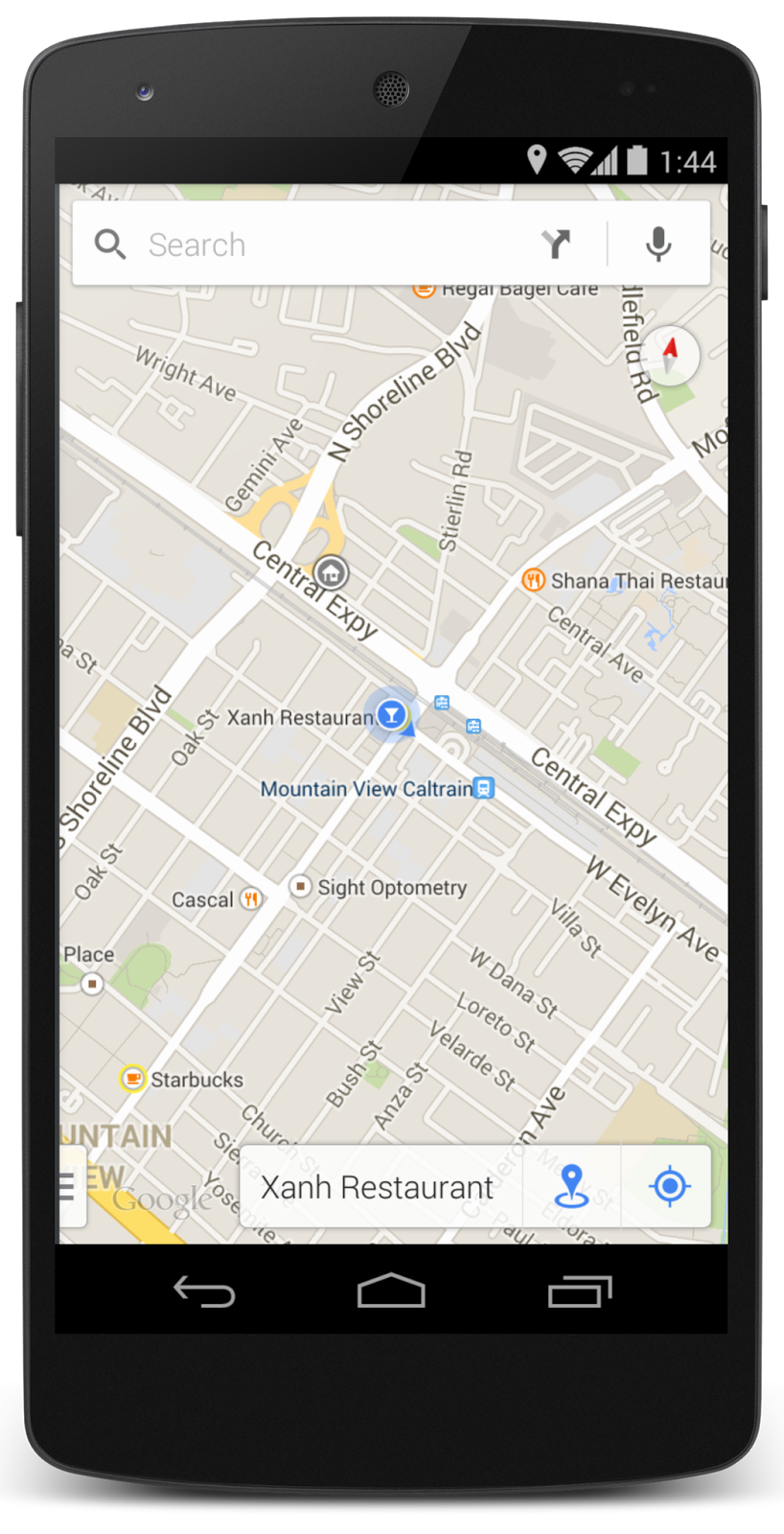
Once you’ve arrived at your destination, you can get even more relevant information. If you’re using an Android device, tap on the My Location button at the bottom right or on the blue dot on the map, and you can quickly access more info about your location such as restaurant reviews and transit schedules, or simply save the place for later. Over time, your location experience will improve as you confirm the places you visit.
So next time you’re deciding where to brunch, or you want to check out your restaurant’s reviews while you wait for friends to arrive, open up your Google Maps app and Explore.
Posted by Taj Campbell, Google Maps Product Manager
Labels
#streetview
#treasuremap
+1
3D
8bitmaps
Adwords Express
Africa
Amazon
Andorra
Android
api
Art Project
Audi
biking
Boost
Boulder
Brazil
Bulgaria
Business Photos
Business View
businesses
Canada
check-in
community
competition
contest
crisis response
Culture
custom maps
developer
Developers
directions
disaster response
discovery
earth outreach
education
Emmy Awards
Enterprise
Estonia
Europe
Explore
Fusion Tables
gadgets
Gibraltar
GMM
google
Google Earth
Google Earth Engine
Google Map Maker
Google Maps
Google Maps API
Google Maps Engine
Google Maps for Mobile
Google Maps Gallery
Google Maps Navigation
Google Maps Transit
Google Places
Google Plus
Google Search
Google Street View
google.org
Google+
googlenew
Grand Canyon
ground truth
Halloween
historical
history
holiday
Hotpot
Hungary
imager
imagery
Indoor Maps
iOS
iPhone
Iraq
Japan
Latitude
Latvia
layers
LBC
Lithuania
London
Making of Maps
Malaysia
Mall of America
Map Maker
Maps Blog
Maps Gallery
mapsgl
Matt Harding
Mexico
Mobile
Monticello
My Maps
my places
my tracks
National Geographic
navigation
new Google Maps
oblique imagery
ocean
offline maps
Olympics
Outreach
Pakistan
Panoramio
Parks Canada
Pegman
Photo Spheres
photo tours
photos
picasa
Polar Bears
Quiz
real estate
restaurants
road trips
Russia
Santa
Santa Tracker
search stories
SketchUp
Slovakia
Slovenia
South Sudan
space
Spain
sports
Street View
summer
SXSW
Tags
Thomas Jefferson
Thomas Jefferson Foundation
Tip of the week
tips
tour guide
traffic
Train
Transit
travel
trees
Trekker
Trike
Trolley
U.S. National Park Service
Ukraine
University of Virginia
Valentine's Day
Veterans Day
Views
voice search
walking
Waze
weather
webgl
Your Timeline
zagat
Archive
2016
Sep
Aug
Jul
Jun
May
Apr
Mar
Feb
Jan
2015
Dec
Nov
Oct
Sep
Aug
Jul
Jun
May
Apr
Mar
Feb
Jan
2014
Dec
Nov
Oct
Sep
Aug
Jul
Jun
May
Apr
Mar
Feb
Jan
2013
Dec
Nov
Oct
Sep
Aug
Jul
Jun
May
Apr
Mar
Feb
Jan
2012
Dec
Nov
Oct
Sep
Aug
Jul
Jun
May
Apr
Mar
Feb
Jan
2011
Dec
Nov
Oct
Sep
Aug
Jul
Jun
May
Apr
Mar
Feb
Jan
2010
Dec
Nov
Oct
Sep
Aug
Jul
Jun
May
Apr
Mar
Feb
Jan
2009
Dec
Nov
Oct
Sep
Aug
Jul
Jun
May
Apr
Mar
Feb
Jan
2008
Dec
Nov
Oct
Sep
Aug
Jul
Jun
May
Apr
Mar
Feb
Jan
2007
Dec
Nov
Oct
Sep
Aug
Jul
Jun
May
Feed
Google
on
Follow @googlemaps
Follow
Give us feedback in our
Product Forums
.
.jpg)




 Follow
