The official blog for Google Maps
Visit the Baltic nations of Estonia and Latvia with Street View
May 15, 2012
You can now virtually visit the Baltic States of Estonia and Latvia using the Street View feature in Google Maps.
Lets start in Estonia with a peek into the capital of
Tallinn
, a medieval city characterized by its cobbled streets and red roofs. Here’s a view the Town Hall Square.
View Larger Map
Also in Tallinn you have the Toompea Castle, which is a historic site built on top of the Toompea Hill and now houses the Parliament of Estonia.
View Larger Map
Moving south to Latvia, lets first visit the square of
Riga Dom Cathedral
, which is one of favourite places both for locals and city guests to relax in an outdoor cafe, listen to live music and experience a true atmosphere of medieval old town.
View larger map
Also, take a look at the bridge over
river Gauja
in
Sigulda
. Thanks to the picturesque valley, many newlyweds choose to cross the bridge, symbolizing their wedding as two shores coming together. If you ever happen to visit (at least on Street View), be sure that you will get only the warmest welcomes from wedding guests.
View larger map
View larger map
There are a ton more sites to visit through Street View and we hope this can inspire you to visit these two countries in the near future! To learn more about Street View please visit
www.google.com/streetview
.
Posted by Karl Pae, Google Estonia and Didzis Vilcans, Google Latvia
And the 2012 Model Your Town Competition winner is…
May 15, 2012
Getaria, Gipuzkoa, Spain!
Over the past several months, hundreds of teams from all over the world have submitted stunning geo-models for our
Google Model Your Town Competition
. These examples of pure 3D civic pride are breathtaking to behold. Difficult as it was, the SketchUp team managed to pick six finalists, after which we asked the general public to vote for their favorite collection of models. Tens of thousands of you weighed in, and the talented team from the north of Spain were victorious.
Zorionak!
(That’s “Congratulations!” in Basque.)
Want to see how they won? Take a look at
Team Getaria’s collection
in the 3D Warehouse, pop over to our
winners’ page
, and watch this video to see their astounding work:
The winning team is a dynamic duo: Josetxo Perez Fernandez, 36, is a professional who works in computer administration; and Pedro Domecq Aguirre, 45, is a programmer, 3D data specialist and network administrator. Those are their day jobs, anyway. It turns out that they’re actually world-class, polygon-wrangling, texture-mapping, megabyte-optimizing, geo-modeling superheroes. And now they’re bona fide local heroes, too. Thanks to them, millions of people across the globe can now get familiar with the beautiful little town of Getaria.
The beautiful coastline of Getaria
Not only that, but we’ll also be awarding US$25,000 to a local school and hosting a celebration with the town of Geteria in honor of Pedro's and Josetxo's accomplishment.
Getaria Lighthouse on Mount San Antón
Zorionak to the winning town, to the other
five finalists
, and to all the other
entrants
who collectively modeled almost 25,000 local landmarks that are now available for all to enjoy in Google Earth’s 3D Buildings layer. The virtual world is a richer place thanks to your efforts, and the real one is a lot better off, too.
Posted by Allyson McDuffie, SketchUp Team
Quickly access your home and work locations in Google Maps
May 15, 2012
With Google Maps, we’ve made it increasingly easy to
save and re-find the places that matter to you
. Last year, we introduced the
My Places tab
which organizes your saved Custom Maps, directions that you’ve previously looked up, and locations you’ve starred, checked-in and rated. Starting today, you’ll also be able to save your home and work locations in Google Maps when signed in with your Google account.
Imagine moving to a foreign country -- this means a new city, a new neighborhood, and even a new apartment to call home. That was how I began my summer last year, moving from Boulder, Colorado to Tokyo, Japan. In a new country where
blocks, not streets, are labeled
and addresses use a
different formatting system
, finding home was a feat in and of itself. And that’s how the idea to save home and work locations in Google Maps was born.
By saving these locations that are common to you in My Places, you’ll be able to access these addresses by simply typing “home” or “work” when searching or getting directions in Google Maps. Using these keywords will create a drop-down suggestion with the address you’ve set so that you no longer have to type the full address into the search box.
By saving your home and work locations in My Places, you’ll also see special icons to easily identify these locations on the map.
To set your home and work locations, you’ll need to sign in with your Google Account. Once logged in, click the
My Places tab
in Google Maps and save your home and work locations. From the My Places panel, you can also edit or delete your saved locations by clicking the drop-down to the right of the home or work icons.
With home and work locations saved in Google Maps, we hope to help you navigate your way to these frequently visited places, regardless of where you may be.
Update (5/15):
Sorry for the delay, but home and work locations in My Places will be available soon. We'll update this post again when the feature is live.
Update (5/25):
Thanks for your patience, home and work locations in My Places is now available.
Posted by Erika Yamasaki, Associate Product Manager Intern
Street View: Your Summer Vacation Preview
May 14, 2012
Summertime means
summer travel
. Whether you're planning the next family trip or group outing,
Google Maps
can help.
Street View’s
immersive views lets you preview your adventure by transporting you to famous landmarks and tourist destinations around the world. Over the years, our
Partner Program
has allowed us to showcase a growing number of notable amusement parks, zoos and other points of interest, with our 360-degree panoramic imagery.
For example, if you’re on the West Coast of the US and want to visit the world famous San Diego Zoo, search for “
San Diego Zoo
” , drag Pegmen to a spot inside the zoo, and take a tour. You can also virtually explore the zoos in
Honolulu
,
Denver
,
Detroit
and more.
San Diego Zoo, View Larger Map
If you’re looking for some amusement without the animals, take a peek at some of the largest amusement parks across the country. Visit
Universal Studios in Orlando, Florida
, and catch a glimpse of how movie magic is made. You can also preview with imagery from
Six Flags Discovery Kingdom
,
Universal Studios Hollywood
,
Santa Cruz Beach Boardwalk
,
Great America
,
Busch Gardens
, and
Wet ‘n’ Wild Hawaii
.
Universal Studios Orlando, View Larger Map
If you’re into high-octane trips to the racetrack, you can take a virtual look at
Mazda Raceway Laguna Seca
or
Infineon Raceway
. Or if peace and quiet is more your speed, you can take a leisurely stroll through
Balboa Park
, the
Chicago Botanic Garden
, or
Diamond Head park
and trail.
Infineon Raceway, View Larger Map
Wherever you choose to adventure, feel free to explore
these popular U.S. locations
from the comfort of your desktop or mobile device. Let Street View imagery help you decide where to go on your next summer getaway. To see more popular locations, check out our
Street View Gallery
.
Posted by Chris Fiock, Program Manager for Street View
Spreadsheet Mapper 3: More placemarks, advanced customization, and more
May 11, 2012
Do you have a spreadsheet of locations that you’d like to see on a map? Here on the
Google Earth Outreach
team we talk to many nonprofits who use
Google Earth
and
Maps
to tell their stories and visualize their data. Often the data is in spreadsheets, or other tabular formats. Converting these rows and columns into a map brings the spreadsheet to life by providing geographic context and a new way to visualize the information.
Spreadsheet Mapper
is a tool that enables anyone to easily create a well-designed
KML file
to show off their data in Google Earth and Maps. Since Spreadsheet Mapper is a
Google Docs
template, you fill in your data using the familiar interface of a spreadsheet, and create a great KML without any coding. It gives you all the cloud-based benefits of Google Docs, including collaborative editing and the ability to publish directly to the web.
When
we released
Spreadsheet Mapper 2 a few years ago, it had a number of limitations, especially with regard to the number of placemarks it could create and the available balloon templates. In response to user feedback, and taking advantage of new features in Google spreadsheets and
Google Apps Scripts
, we have upgraded Spreadsheet Mapper with a variety of new and improved features:
More placemarks: Support for 1,000 placemarks and ability to add more as needed
Flexible balloon design: Take advantage of even more balloon design templates and simplified starter templates
Simplified publication: Just click “Publish to the web” to share your map (no more fussing with URLs)
New customization options: Advanced users can change the default view and network link details
Ready to try it? The
Spreadsheet Mapper v3 tutorial
will get you started.
We hope these new tools make mapping from spreadsheet data easier than ever!
Posted by Christiaan Adams, Developer Advocate with the Google Earth Outreach team
Shop and travel smarter with Google Maps 6.7 for Android - now with Google Offers and indoor walking directions
May 9, 2012
(Cross-posted on the
Official Google Mobile Blog
)
Wherever you are, Google Maps for Android helps you get around and discover new places. Today with the
6.7 release
we will help you find offers from nearby businesses in the U.S. -- everything from restaurants, to salons, to city tours. Also, we’ve added indoor walking directions in the U.S. and Japan, plus 360-degree interior photos of businesses, to help you intrepidly make your way indoors and out.
Discover great offers near you
Today, in the U.S. only, we’re launching a way to discover nearby
Google Offers in Google Maps for Android
. To see great deals near you, tap on “Maps” to open the dropdown menu and then tap on “Offers.” If you see something you like you can click on it to learn more. Some Google Offers can be purchased and saved for later while others are immediately available for free. With free Google Offers, press “Use now” to redeem instantly or “Save for later” for future use. You can also opt-in to receive notifications in the app when there are offers near you.
Explore the great indoors with walking directions and Business Photos.
Since we launched
indoor maps
in the U.S. and Japan in Google Maps for Android last November, business owners have been adding their floor plans to our maps with
Google Maps Floor Plans
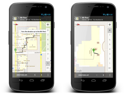
. Today, we are launching indoor walking directions for participating venues in these countries. This will help you get directions not only to a building’s front door, but also through those doors to the places where
you want to go inside
.
Get Indoor walking directions in indoor maps (photo: Macy’s San Francisco)
With
Google Business Photos
you can explore panoramic photos of the inside of a business from the palm of your hand. Now you can get a feel for a restaurant or store inside as well as outside using Street View technologies. To access these 360-degree panoramic views, look for the “See Inside” section on the Place page of select businesses.
See the interior of participating businesses with Business Photos (photo: Toyjoy)
Download Google Maps 6.7 for Android from
Google Play
, and use it as your trusted guide to help you find and discover places to eat, shop and play! You can also learn more about other great features on the
Google Maps YouTube channel
.
Posted By Benjamin Grol, Product Manager for Google Maps for Android
Bringing Business Photos to more users and business owners
May 1, 2012
Since April 2010, we’ve been testing and developing the
Business Photos program
, which gives users a virtual peek inside businesses through interactive 360-degree imagery. After hearing your
positive feedback
about how showing off panoramic views of your business interiors helps you attract potential customers, we’re excited to announce further expansion of this program. Starting today, in addition to the United States, the United Kingdom, Australia, New Zealand and France, this service is now available in Canada, Ireland and the Netherlands.
Through the Business Photos program, if you’re a business owner in any of these locations around the world, getting started is easy. Just hire a
Trusted Photographer
in your area to take pictures of your establishment at a time convenient for you. Panoramas are created using the photos, and customers can easily find the resulting panoramic images on Google.com, on Google Maps, and on your Google Places listing. This self-service model, introduced
several months ago
, not only supports talented photographers in your local community, but also gives people who are thinking about visiting your location a sense of what they can expect when they walk through your doors. And if a local photographer isn’t yet available in your neighborhood,
let us know
so we can figure out where else to expand the program.
And whether you’re a professional photographer or an enthusiastic amateur, we’d love to have you on board! We are actively recruiting more Trusted Photographers to bring imagery of more local businesses online for millions across the globe to see. Visit our
website for photographers
to learn more and
sign up
.
View Larger Map
Click and drag to view the inside of
Casa Artelexia
in San Diego, California
And if you’re simply curious and want to explore businesses — from top-rated restaurants to exotic pet stores — check out this
gallery of interior business photos
on the Street View website.
Posted by Gadi Royz, Product Manager, Google Maps
Labels
#streetview
#treasuremap
+1
3D
8bitmaps
Adwords Express
Africa
Amazon
Andorra
Android
api
Art Project
Audi
biking
Boost
Boulder
Brazil
Bulgaria
Business Photos
Business View
businesses
Canada
check-in
community
competition
contest
crisis response
Culture
custom maps
developer
Developers
directions
disaster response
discovery
earth outreach
education
Emmy Awards
Enterprise
Estonia
Europe
Explore
Fusion Tables
gadgets
Gibraltar
GMM
google
Google Earth
Google Earth Engine
Google Map Maker
Google Maps
Google Maps API
Google Maps Engine
Google Maps for Mobile
Google Maps Gallery
Google Maps Navigation
Google Maps Transit
Google Places
Google Plus
Google Search
Google Street View
google.org
Google+
googlenew
Grand Canyon
ground truth
Halloween
historical
history
holiday
Hotpot
Hungary
imager
imagery
Indoor Maps
iOS
iPhone
Iraq
Japan
Latitude
Latvia
layers
LBC
Lithuania
London
Making of Maps
Malaysia
Mall of America
Map Maker
Maps Blog
Maps Gallery
mapsgl
Matt Harding
Mexico
Mobile
Monticello
My Maps
my places
my tracks
National Geographic
navigation
new Google Maps
oblique imagery
ocean
offline maps
Olympics
Outreach
Pakistan
Panoramio
Parks Canada
Pegman
Photo Spheres
photo tours
photos
picasa
Polar Bears
Quiz
real estate
restaurants
road trips
Russia
Santa
Santa Tracker
search stories
SketchUp
Slovakia
Slovenia
South Sudan
space
Spain
sports
Street View
summer
SXSW
Tags
Thomas Jefferson
Thomas Jefferson Foundation
Tip of the week
tips
tour guide
traffic
Train
Transit
travel
trees
Trekker
Trike
Trolley
U.S. National Park Service
Ukraine
University of Virginia
Valentine's Day
Veterans Day
Views
voice search
walking
Waze
weather
webgl
Your Timeline
zagat
Archive
2016
Sep
Aug
Jul
Jun
May
Apr
Mar
Feb
Jan
2015
Dec
Nov
Oct
Sep
Aug
Jul
Jun
May
Apr
Mar
Feb
Jan
2014
Dec
Nov
Oct
Sep
Aug
Jul
Jun
May
Apr
Mar
Feb
Jan
2013
Dec
Nov
Oct
Sep
Aug
Jul
Jun
May
Apr
Mar
Feb
Jan
2012
Dec
Nov
Oct
Sep
Aug
Jul
Jun
May
Apr
Mar
Feb
Jan
2011
Dec
Nov
Oct
Sep
Aug
Jul
Jun
May
Apr
Mar
Feb
Jan
2010
Dec
Nov
Oct
Sep
Aug
Jul
Jun
May
Apr
Mar
Feb
Jan
2009
Dec
Nov
Oct
Sep
Aug
Jul
Jun
May
Apr
Mar
Feb
Jan
2008
Dec
Nov
Oct
Sep
Aug
Jul
Jun
May
Apr
Mar
Feb
Jan
2007
Dec
Nov
Oct
Sep
Aug
Jul
Jun
May
Feed
Google
on
Follow @googlemaps
Follow
Give us feedback in our
Product Forums
.




 Follow
