The official blog for Google Maps
Evolving the look of Google Maps, redux
July 19, 2011
Hot on the heels of our
new style
for the
Google Maps
user interface, today we are pushing out some further improvements to our map design to match the updated look and feel and further improve the usability of our maps.
Amongst the changes you will find a plethora of subtle changes, designed to make the map cleaner, more focused, more visually harmonious, and easier to use. Some highlights to look out for are a brighter and more cheerful color palette, a more integrated and less visually noisy labeling style, subtle improvements to footpaths and minor roads, and cleaner building and land parcel rendering.
Most of these improvements, like many that we’ve made over the last couple of years, are gentle enough that many people won’t even notice the difference. When you add them together, however, and then compare to how the map looked even as recently as two years ago, it’s remarkable to see how dramatic the change is.
Compare how our maps of New York looked in 2009, then again the same time in 2010, and now with the new tiles for 2011. The improved colour scheme and less jarring label outlines help the labels to feel part of the map, as opposed to a distracting overlay. It’s also easier to distinguish the city name, neighborhoods, and roads through subtle changes in label color:
The visually heavy highway shields are now integrated into the road labels, and the brighter and cleaner style shifts the focus onto the road names and prominent landmarks in the area. London is one place that benefits from this:
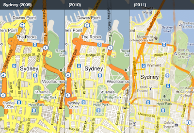
The style evolution has enabled us to place more information whilst still making the map feel simpler. In the case of Sydney, thinner and cleaner roads, better representation of tunnels, more subtle footpaths in the parks, and more subtle labeling all contribute:
We hope you enjoyed this quick retrospective and find the new improvements to the map style helpful. There are many more than have been highlighted here, so have a look around
Google Maps
today and see if you can spot any improvements to your local area. Happy exploring!
Posted by Jonah Jones, User Experience Designer
Imagery Update: Week of July 18th
July 18, 2011
The
Commissioners’ Plan of 1811
proposed a highly regular grid pattern as the layout for an island that was mostly farmland and wilderness in a still-young country. Two hundred years after the streets and avenues were dreamed up, the landscape of New York City has changed dramatically as skyscrapers have been built, parks have been planted and the population has increased by millions. Today’s latest batch of updated imagery reveals new, high resolution imagery of Manhattan. It’s now live in
Google Earth
and will appear in
Google Maps
soon.
Times Square has become much more pedestrian-friendly
.
Construction at the World Trade Center site is making clear progress.
Google NYC is located in the Chelsea neighborhood of Manhattan. I’m one of more than 2,000 Googlers here (split between Sales, Engineering, and other functions), making us the second-largest Google location. (
Care to join us?
) The sales team sits in
Chelsea Market
, a former Nabisco factory where Oreos were invented and which envelops the elevated
High Line
, which was recently converted into a park.
This new batch of imagery also covers another Google hometown: Boulder, Colorado, home to the 3D team that brings you
Google SketchUp
and the
Google 3D Warehouse
. That team expanded two months ago across the street.
Want to check out how these places used to look? Use the
Historical Imagery
feature of Google Earth to slide back the clock around the world. And as always, we encourage you to check out more of the areas that can be seen in our latest imagery update. Enjoy!
High resolution aerial updates:
Boise, ID; Denver, CO; Topeka, KS; St Cloud, MN; Ashland, WI; Ironwood, MI; Flint, MI; Ft Wayne, IN; Cape Girardeau, MO; Bowling Green, KY; Glasgow, KY; Greenville, NC; Atlantic City, NJ; Syracuse, NY; Manhattan, NY
Countries/regions receiving high resolution satellite updates:
Canada, United States, Mexico, Cuba, The Bahamas, The Dominican Republic, Belize, Guatemala, El Salvador, Honduras, Nicaragua, Costa Rica, Panama, Colombia, Venezuela, Ecuador, Brazil, Peru, Paraguay, Bolivia, Argentina, Chile, Madagascar, South Africa, Lesotho, Swaziland, Namibia, Botswana, Mozambique, Zambia, Angola, Tanzania, Democratic Republic of the Congo, Uganda, Kenya, Somalia, Ethiopia, Sudan, Eritrea, Egypt, Niger, Burkina Faso, Ghana, Sierra Leone, Mali, Senegal, The Gambia, Mauritania, Morocco, Algeria, Yemen, Saudi Arabia, United Arab Emirates, Qatar, Kuwait, Jordan, Israel, Syria, Lebanon, Iran, Turkey, Russia, Finland, Sweden, Norway, Estonia, Latvia, Belarus, Ukraine, Poland, Hungary, Romania, Bulgaria, Greece, Albania, Serbia, Croatia, Austria, Germany, Italy, Switzerland, France, Spain, Portugal, England, Azerbaijan, Kazakhstan, Uzbekistan, Kyrgyzstan, Pakistan, India, Sri Lanka, Bangladesh, Nepal, China, Myanmar, Laos, Thailand, Vietnam, Cambodia, Malaysia, Taiwan, The Philippines, Japan, Korea, Indonesia, Australia, New Zealand
These updates are now available in Google Earth and coming soon to Google Maps. To get a complete picture of where we updated imagery, download
this KML
for viewing in Google Earth.
To get automatic updates when we update places you care about, set your targets at
Follow Your World
and you’ll be among the first to know by email.
Posted by Jesse Friedman, Product Marketing Manager
Celebrate Marine Day by exploring the shinkai
July 17, 2011
The ocean covers approximately 70 percent of the Earth’s surface and yet remains one of the most mysterious places on the planet. In Japan, bodies of water with depths over 200m (656 feet) are referred to as shinkai, or deep sea. These dark regions of the ocean do not receive light and water pressure is up to 100x higher than at the surface, making the shinkai inaccessible to most exploration.
In honor of
Marine Day
in Japan, we collaborated with
JAMSTEC
(Japan Agency for Marine-Earth Science and Technology) and the manned
Shinkai 6500 submarine
to share this hidden world through
Google Earth
.
Dive beneath the surface
to explore the shinkai, as well as
shipwrecks
,
research discoveries
,
surf spots
and more.
The Shinkai 6500 is able to dive to depths of 6,500m (21,325 feet), a feat few other vessels can match. It is equipped with a variety of research devices such as search lights, cameras and robotic arms. A cockpit enables three pilots to withstand the extreme conditions and even includes a spyglass for visual exploration of the deepest parts of the ocean.
Shinkai 6500’s cockpit
Shinkai 6500’s mission is to bring the secrets of the deep sea to the surface for marine enthusiasts. It studies movement of the Earth’s interior, living organisms equipped to survive the most extreme conditions and the impact of hydrothermal activity on the environment.
In order to bring this research to life, we worked with JAMSTEC to create a Google Earth tour showcasing past Shinkai 6500 endeavors to the ocean floor. Join the crew by downloading the KML file (in
English
or
Japanese
) and opening in Google Earth.
The Shinkai 6500 tour highlights previous deep sea missions and marine life.
As the submarine descends, you will learn more about the vessel and the creatures it finds in the deepest parts of the ocean, including historical imagery from past ventures. Discover unique deep sea features and lifeforms - from rare translucent fish such as the Liparis to hydrothermal vents known as white smokers.
Learn more about life at the bottom of the sea as the Shinkai 6500 explores the Google Earth ocean.
We hope the Shinkai 6500 inspires you to continue to explore the deep sea and its hidden treasures. We recommend starting with the
ocean seafloor tour
or
deep sea vents ridge 2000
. You can find even more ocean tours in the
Ocean Showcase
on the
Google Earth website
.
Posted by Yosuke Murakami, Program Manager, Geo Japan
UNITAR/UNOSAT team up with Google Map Maker to boost impact of community mapping for disaster relief and humanitarian aid
July 15, 2011
In times of disaster and humanitarian needs, relief activities are sometimes carried out in chaotic and dynamic conditions in which multiple groups need to interact. First responders need to quickly build an on-the-ground picture of where people are, what condition they are in, what their needs are, what services are still available, and what resources have survived. This helps relief and humanitarian responders as well as local planners to plot and obtain a big picture of the impact of the disaster. They are then able to target their efforts and mobilize their resources of equipment, personnel, and supplies. Unfortunately, despite many technical and institutional advances, basic data is often not readily available on the onset of a disaster.
As Einar Bjorgo, UNITAR/UNOSAT's head of Rapid Mapping, Applications and User Relations, has noted,
Google Map Maker
addresses a significant part of this data gap by capturing community knowledge -- verified through community moderation -- and making it available in near real-time. UNITAR/UNOSAT is the only operational UN program fully focused on providing satellite imagery and mapping products to the humanitarian community, including its United Nations’ sister agencies and governments -- and it now does so largely with Google’s Map Maker data.
Today, after years of
successful collaboration
, UNITAR/UNOSAT (the operational satellite applications program of UNITAR) and Google have strengthened their joint efforts by signing an agreement that will give the crisis response and humanitarian community increased access to Google Map Maker source data for use in their disaster response and humanitarian activities, in more than 150 countries around the world.*
Under this agreement UNITAR/UNOSAT will act as a conduit within the United Nations family and its Member States to make
Google Map Maker
data more widely and easily available to aid organizations in the event of major disasters and for humanitarian efforts. In addition, government and United Nations agencies will be able to contact UNOSAT/UNITAR (email unosat@unitar.org) for consideration as potential licensees of the Google Map Maker data, for their disaster response, humanitarian and development projects. This agreement builds on dozens of previous joint mapping efforts between UNITAR/UNOSAT and Google, such as the ones that were coordinated for
Pakistan
,
Sudan
, and
West Africa
.
UNOSAT Manager Francesco Pisano shared his thoughts, noting that "Google Map Maker gives us access to baseline data over areas where detailed information is usually unavailable. Now roads, bridges, buildings, and other services, with local and official names, can be mapped and damages tracked in near real-time. This new ability to integrate Google Map Maker data more widely into our satellite analysis will have a monumental impact on UNOSAT’s ongoing efforts to make geographic information a key part of providing information for modern humanitarian relief. This agreement will also bring key benefits to the broader disaster and humanitarian community by making Google Map Maker data more widely and easily available.”
UNOSAT map
of the flood-affected areas in Pakistan. It uses Map Maker data as its primary source of Road and Place names data.
With this new agreement with UNITAR/UNOSAT, we are expanding our ability to share useful map data that the Map Maker community contributes with the world, for increased benefit to people all over in preventing and recovering from man-made and natural hardships. We’re thrilled to deepen our relationship with the United Nations, and their partners. We welcome you to join the
Map Your World Community
, and
start mapping
to contribute to this effort and increase the quality of maps data. If you are one of our long-term mappers, thank you for your efforts that inspire us to keep finding ways to together make a positive difference to the world.
Keep mapping
!
Posted by France Lamy, Program Manager, Google.org
*Countries for which UNITAR/UNOSAT will have access to Google Map Maker data: Afghanistan, Albania, Algeria, American Samoa, Angola, Anguilla, Antigua and Barbuda, Argentina, Armenia, Aruba, Bahamas, Bahrain, Bangladesh, Barbados, Belarus, Belize, Benin, Bermuda, Bolivia, Botswana, Bouvet Island, British Indian Ocean Territory, British Virgin Islands, Brunei,Burkina Faso, Burundi,Cambodia, Cameroon, Cape Verde,Cayman Islands, Central African Republic, Chad, Chile, Christmas Island, Cocos (Keeling) Islands, Colombia, Comoros, Congo, Cook Islands, Costa Rica, Cote d'Ivoire, Cuba, Democratic Republic of the Congo, Djibouti, Dominica, Dominican Republic, Ecuador, El Salvador, Equatorial, Guinea, Eritrea, Ethiopia, Faroe Islands, Fiji, French Polynesia, French Southern and Antarctic Lands, Gabon, Gambia, Ghana, Greenland, Grenada, Guadeloupe, Guatemala, Guinea, Guinea-Bissau, Haiti, Honduras, Iceland, Iraq, Jamaica, Jordan, Kazakhstan, Kiribati, Kuwait, Kyrgyzstan, Laos, Liberia, Libya, Madagascar, Malawi, Malaysia, Maldives, Mali, Malta, Marshall Islands, Mauritania, Mauritius, Micronesia, Mongolia, Montenegro, Montserrat, Morocco, Mozambique, Myanmar (Burma), Namibia, Nauru, Nepal, Netherlands Antilles, New Caledonia, Nicaragua, Niger, Nigeria, Niue, Norfolk Island, North Korea, Northern Mariana Islands, Oman, Pakistan, Palau, Panama, Papua New Guinea, Paraguay, Peru, Philippines, Pitcairn Islands, Qatar, Romania, Rwanda, Saint Helena, Saint Kitts and Nevis, Saint Lucia, Saint Pierre and Miquelon, Saint Vincent and the Grenadines, Samoa, Sao Tome and Principe, Senegal, Seychelles, Sierra Leone, Solomon Islands, Somalia, Sri Lanka, Sudan, Suriname, Svalbard and Jan Mayen, Swaziland, Tajikistan, Tanzania, Timor-Leste, Togo, Tokelau, Tonga, Trinidad and Tobago, Tunisia, Turkmenistan, Turks and Caicos Islands, Tuvalu, Uganda, Uruguay, Uzbekistan, Vanuatu, Venezuela, Vietnam, Wallis and Futuna, Western Sahara, Yemen, Zambia, Zimbabwe
Live traffic information for 13 European countries
July 13, 2011
Since introducing the live traffic feature on Google Maps in
2008
, our team has been working hard to make this feature available to more users in more countries. Just in time for summer travel, we’re delighted to announce that today we’re making traffic available in 13 countries in Europe. The new road traffic information is in the traffic layer on
Google Maps
and
Google Maps for mobile
, and
Google Maps Navigation (Beta)
.
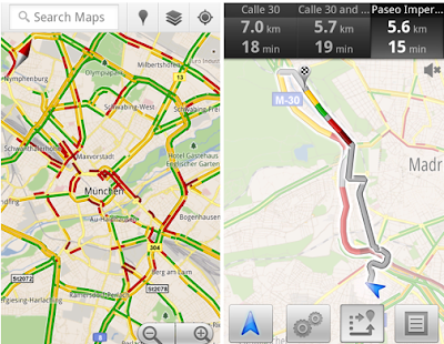
Left: Traffic layer Right: Getting routed around traffic in
Google Maps Navigation
Today we’re announcing new coverage in Austria, Belgium, Czech Republic, Denmark, Germany, Ireland, Israel, Luxembourg, Netherlands, Poland, Slovakia, Spain and Switzerland. Coverage includes all freeways and highways, as well as large roads in major cities. Users in the UK will also benefit from a finer grain of street level coverage.
Our Maps team in Zurich is especially excited about this release because many of us will now be able to personally benefit from the expansion of this traffic feature. For example, although I take public transit to work every day, I enjoy weekend drives to the Austrian Alps or the Italian lakes region, and having live traffic available on my phone helps me avoid the traffic at the
Gotthard tunnel.
Traffic in Gotthard Tunnel, Switzerland
The live traffic layer is regularly updated to show information for traffic events from the last 5-10 minutes. Finally, you can learn more about typical traffic conditions for specific times and days of the week by clicking the “change” link in the traffic legend on Google Maps, and setting the day of week and time.
Posted by Csaba Garay, Technical Account Manager
A cause to celebrate in Pakistan with Google Map Maker
July 12, 2011
The month of June proved fruitful for mapping enthusiasts, tech buffs, and entrepreneurs throughout Pakistan as they gathered for a series of
Google MapUps
organized at universities in three major cities:
Islamabad
,
Lahore
and
Karachi
.
Led by Google Pakistan Country Consultant,
Badar Khushnood
and a trio of
Pakistan’s Map Maker Advocates
—Faraz Ahmad, Jabran Rafique and Omer Sheikh—the three events welcomed a total of 150 participants to learn the ins and outs of
Google Map Maker
. The intent of the MapUps was to guide new users through the process of mapping their cities and neighborhoods while stressing the importance of having a complete map of Pakistan available online.
Recent mapping efforts in Pakistan have been predominantly aligned with relief efforts following Pakistan’s 2010
floods
and
landslides
, as demonstrated by
Omer, Jabran and Faraz
.
Dr. Sayeed Ghani
spoke at the Karachi MapUp about
Sindh Flood Maps
, his community-based geographic information system (GIS) that implements a Google Maps API to assist in disaster management.
Dr. Sohaib Khan
, who co-hosted the Lahore MapUp, has also
focused on flood relief
.
On a basic level, the aim of MapUps is to teach new and aspiring mappers the fundamentals of Map Maker, and to bring them together to map their community. Omer explained that “The idea is to get the participants started in the hope that they will continue mapping in the future.” Badar Khushnood and our Mapping Advocates ultimately highlighted the tools and motivation behind mapping, highlighting it as influential, inspirational, and humanitarian.
Google MapUp, NU-FAST, Islamabad, Pakistan
Learn more about hosting a
Google MapUp
in your own community, and be sure to visit our Advocates and other passionate and helpful mappers in our
Map Your World Community
.
Posted by Lori Savageau, Community Manager
Using Street View to digitally archive Japan’s disaster zones
July 11, 2011
After the March 11 earthquake and tsunami devastated the coastal communities of Eastern Japan, we at Google tried to find ways to use our technologies in support of relief activities. This started immediately after the quake with our
Person Finder
to help locate displaced individuals, and more recently we’ve started projects to spur economic recovery in the affected areas, such as the “
YouTube Business Support Channel,
” which enables local businesses to promote their products and establishments to a nationwide audience.
We also believe that the Street View feature in Google Maps can be a useful tool to offer street-level imagery of the recovery efforts. Many photographers felt the disaster couldn’t be captured in just one photo or with a single camera, but immersive, 360-degree panoramic images can help people — especially those abroad — better understand the scope of the destruction.
On July 8, we announced that we’ll be driving our Street View cars across major cities (such as Sendai) and coastal cities of the Tohoku region to not only help communicate the current state of the disaster-affected areas, but also to digitally archive the area’s landscapes for future generations. This imagery will help people in Japan and across the world remember and observe the tragedy of March 11, 2011.
In addition to preserving history through Street View, the team in Japan has been busy publishing 360-degree imagery of more than 100 famous sites across Japan through our
Street View Partner Program
. The places that have partnered with us to share views of their locations on Google Maps include UNESCO world heritage sites
Yakushi-ji
temple,
Toshodai-ji
temple, and
Kasuga-Taisha
shrine in the ancient capital city of Nara. We’re also continuing the
Business Photos project
in Japan and are working with hundreds of businesses to photograph their interiors, get those images online, and show both local customers and visitors that they are open for business.
Yakushi-ji Temple in Nara, Japan
If you’re interested in directly supporting the ongoing relief effort in Japan, you can find more information regarding the disaster and resources for those in need at our Crisis Response page in
English
and
Japanese
.
Posted by Ken Tokusei, Product Management Director, Geo Asia-Pacific, on behalf of Google Japan and international Crisis Response teams
Labels
#streetview
#treasuremap
+1
3D
8bitmaps
Adwords Express
Africa
Amazon
Andorra
Android
api
Art Project
Audi
biking
Boost
Boulder
Brazil
Bulgaria
Business Photos
Business View
businesses
Canada
check-in
community
competition
contest
crisis response
Culture
custom maps
developer
Developers
directions
disaster response
discovery
earth outreach
education
Emmy Awards
Enterprise
Estonia
Europe
Explore
Fusion Tables
gadgets
Gibraltar
GMM
google
Google Earth
Google Earth Engine
Google Map Maker
Google Maps
Google Maps API
Google Maps Engine
Google Maps for Mobile
Google Maps Gallery
Google Maps Navigation
Google Maps Transit
Google Places
Google Plus
Google Search
Google Street View
google.org
Google+
googlenew
Grand Canyon
ground truth
Halloween
historical
history
holiday
Hotpot
Hungary
imager
imagery
Indoor Maps
iOS
iPhone
Iraq
Japan
Latitude
Latvia
layers
LBC
Lithuania
London
Making of Maps
Malaysia
Mall of America
Map Maker
Maps Blog
Maps Gallery
mapsgl
Matt Harding
Mexico
Mobile
Monticello
My Maps
my places
my tracks
National Geographic
navigation
new Google Maps
oblique imagery
ocean
offline maps
Olympics
Outreach
Pakistan
Panoramio
Parks Canada
Pegman
Photo Spheres
photo tours
photos
picasa
Polar Bears
Quiz
real estate
restaurants
road trips
Russia
Santa
Santa Tracker
search stories
SketchUp
Slovakia
Slovenia
South Sudan
space
Spain
sports
Street View
summer
SXSW
Tags
Thomas Jefferson
Thomas Jefferson Foundation
Tip of the week
tips
tour guide
traffic
Train
Transit
travel
trees
Trekker
Trike
Trolley
U.S. National Park Service
Ukraine
University of Virginia
Valentine's Day
Veterans Day
Views
voice search
walking
Waze
weather
webgl
Your Timeline
zagat
Archive
2016
Sep
Aug
Jul
Jun
May
Apr
Mar
Feb
Jan
2015
Dec
Nov
Oct
Sep
Aug
Jul
Jun
May
Apr
Mar
Feb
Jan
2014
Dec
Nov
Oct
Sep
Aug
Jul
Jun
May
Apr
Mar
Feb
Jan
2013
Dec
Nov
Oct
Sep
Aug
Jul
Jun
May
Apr
Mar
Feb
Jan
2012
Dec
Nov
Oct
Sep
Aug
Jul
Jun
May
Apr
Mar
Feb
Jan
2011
Dec
Nov
Oct
Sep
Aug
Jul
Jun
May
Apr
Mar
Feb
Jan
2010
Dec
Nov
Oct
Sep
Aug
Jul
Jun
May
Apr
Mar
Feb
Jan
2009
Dec
Nov
Oct
Sep
Aug
Jul
Jun
May
Apr
Mar
Feb
Jan
2008
Dec
Nov
Oct
Sep
Aug
Jul
Jun
May
Apr
Mar
Feb
Jan
2007
Dec
Nov
Oct
Sep
Aug
Jul
Jun
May
Feed
Google
on
Follow @googlemaps
Follow
Give us feedback in our
Product Forums
.






 Follow
