The official blog for Google Maps
Responding to the fires in San Bruno
September 10, 2010
Update
at 6:27pm
: We now have updated satellite imagery (from
GeoEye
) of the area. You can download it
here
and view it in Google Earth.
Like many friends in the Bay Area and across the country, I’ve been stunned by the images of raging fires in San Bruno. Nearly 40 structures have been destroyed and 120 damaged, with several fatalities and multiple injuries after the explosion of a gas line. More than 100 people have been evacuated to nearby shelters.
This disaster strikes close to home; our YouTube offices are about two miles away from the main gas explosion. We’re thankful that no Google employee was hurt, but remain concerned for the well-being of our neighbors in the area.
We are donating an initial amount of $50,000 to the
American Red Cross Bay Area Chapter
to help with relief efforts. We’re directing Googlers to the local blood drives today and will be hosting blood drives in our San Bruno, Mountain View and San Francisco offices early next week.
We’ve created
this map
to show the location of the explosion and highlight nearby shelters and resources. The map is open for collaboration and welcomes additional useful information. We encourage you to embed it in your website or blog. We are also exploring the possibility of obtaining updated imagery of the area to help responders visualize the scope of the disaster.
View
San Bruno Gas Explosion
in a larger map
Our hearts go out to our neighbors who have been affected by the explosion. We thank the firefighters and first responders who have been working tirelessly to contain the fires and help the residents of San Bruno. You can donate to help
here
.
Posted by Laszlo Bock, VP of People Operations
Walk this way
September 9, 2010
[Cross-posted from the
Google Mobile Blog
]
Whether you’re going for an urban hike or wandering from your hotel to find that restaurant you passed earlier, you won’t have to flag down a local if you’ve got
Google Maps for mobile
4.5 on Android. Maps already had
Navigation
and
walking directions
, and today we’re happy to share the perfect marriage of the two: Walking Navigation (Beta). If you need help deciding where to walk (or drive), you can now also use Street View smart navigation or the new Google Maps search bar to guide your choice.
Walking Navigation
Walking Navigation lets you use GPS navigation with walking directions that are more
direct and use pedestrian pathways
when we know about them. To try it now, choose the “Walking” option from the Navigation icon. Walking Navigation has a few changes that help when you’re on your feet. For example, your phone will vibrate when you need to make a turn. You can even turn off voice guidance and just use these notifications while soaking in the sights and sounds around you. To help you orient yourself with your surroundings, the map will rotate with you as you turn the phone, and walking mode uses satellite view by default. Use it like a virtual compass with satellite imagery to look ahead or help pick out landmarks along the way.
Keep in mind that Walking Navigation is still in beta, and Google Maps may not always have up-to-date information or optimal walking routes. Whether you’re walking or driving with
Google Maps Navigation
, you should always
be safe
and pay attention to road signs, follow signals, and use good judgment about routes that can’t be walked.
Street View smart navigation
If you want a sneak preview of where you’re going, use the new Street View on Google Maps with smart navigation and updated imagery. Just like with
Street View smart navigation on your computer
, you no longer have to slowly move down a street by tapping arrows along roads repeatedly. Now you can quickly navigate Street View by dragging
Pegman
from the corner and highlighting where you want to go with a lightly shaded “pancake” on roads or a rectangle on buildings. Let go of the screen when highlighting the front of a building, and you’ll fly there and turn to face it. With a swipe of your finger, you can hop rivers and scale buildings.
You’ll need to download an update for the “Street View on Google Maps” app in Android Market separately from Google Maps. Once you update, access Street View just like before: open Maps, search for a place or long-press the map, and choose the Street View option if available.
New Google Maps search bar
At the top of the map, you’ll find the new Google Maps search bar always available for easy access. Tap it to quickly start searching,
open Places
, use the Layers menu, or find yourself on the map with My Location. Here are more new features that may be helpful when you’re looking for nearby places:
Filter search results by distance or ratings
View prices categorized with dollar signs
See cross streets for places.
Google Maps for mobile 4.5 and Street View smart navigation are available now for Android 1.6+ everywhere they’re currently available. Search for
Google Maps
(tap
here
on your phone) and then
Street View on Google Maps
(tap
here
) in Android Market to update both.
Visit our
Help Center
to learn more or tell us your feedback and questions in our
Help Forum
. Give us suggestions and vote on other people’s on the
Mobile Product Ideas
page.
Posted by Andrey Ulanov and Kevin Law, Software Engineers
Fly to...a whole new website for Google Earth
September 9, 2010
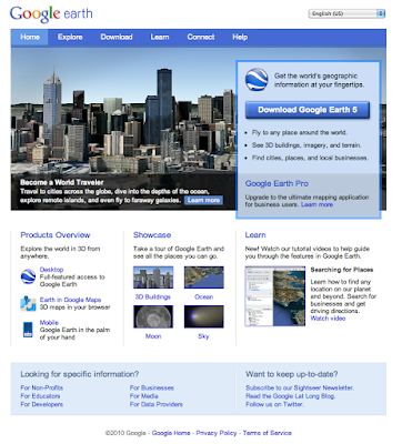
When you think of Google Earth, you might think about flying to the top of Mt. Everest, surveying the ancient Acropolis, or simply finding the house where you grew up. For the past five years, people all over the world have been discovering new places to explore through our community, blogs, news articles and Gallery. Now you can go to one place—our brand new
Google Earth website
—to find everything you’re looking for.
The new site is loaded with lots of great content including images, videos, tours, maps and tutorials on how to get started with Google Earth. We invite you to explore the new site, starting with these five areas:
Showcase
: Browse our
collection of featured content
about the Ocean, Moon, 3D buildings and more to see all the ways you can explore the world around you.
Video tutorials
: Whether you’re new to Google Earth or an expert user, watch our new
video tutorials
to learn how to create placemarks, record a tour, add a 3D building, import GPS data and more.
More products
: See all the
different ways
you can experience Google Earth. Did you know you can access the 3D globe from your phone or on Google Maps?
Community
:
Get connected
with other Google Earth fans in our forums and stay up-to-date through our newsletter, blog and Twitter feeds.
Industries
: Everyone uses Google Earth for a different reason, so we created unique pages for
educators
,
media
,
developers
,
businesses
,
non-profits
and
data providers
.
Now it’s your turn to explore the website on your own. Right now, it’s only available in English but don’t worry, we’ll be adding more languages soon. Check out what’s new with Google Earth at
earth.google.com
.
Posted by Tasha Danko, Product Marketing Manager
Faster, Larger, Closer: Regionation in Google Earth Pro 5.2
September 8, 2010
[Cross-posted from the
Google Enterprise Blog
]
We’re excited to announce that Google Earth Pro 5.2 is now out of beta. With the initial launch two months ago, we detailed the
new features
that are available to all Google Earth users, including Multitrack and Elevation Profile, and outlined the new
Google Earth Pro Data Layers
.
Today we’d like to take this opportunity to highlight some of the most exciting new features that are exclusively available to
Google Earth Pro
customers. Vector and Image Regionation make it possible to integrate even more of your own data and imagery into the Google Earth globe, while maintaining the fast, 3D performance you and other professionals rely on.
Vector Regionation
Watch this video to witness the difference Vector Regionation can make when importing your data.
In a nutshell, Regionation allows Google Earth Pro to display huge amounts of data. It does so by breaking the data or imagery into the smallest necessary components. This means that only the data that is in view needs to be retrieved. You can think of Regionation as a hierarchical subdivision of points or tiles, which shows less detail from afar, and more detail as you zoom in to the globe. This dynamic loading creates clearer visualizations by minimizing clutter, while simultaneously speeding up the rendering process.
Imagine importing a long list of customer assets that are all geocoded to a small, heavily populated urban area, such as a neighborhood in New York City or Tokyo. It would be possible to have more than 100,000 assets within a single square mile radius. If you were viewing this area in the context of the rest of the city, all of the data would overlap, preventing you from making out individual points. However, Vector Regionation solves this problem.
Image Regionation
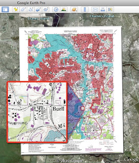
This
U.S. Geological Survey
image of Mineral Resources in Portsmouth, Virginia highlights the amount of detail that’s preserved through Image Regionation.
Image Regionation, otherwise known as Super Image Overlays, allows you to overlay your own high-resolution imagery and view it in varying levels of detail without taxing your system or degrading the quality. The addition of Super Image Overlays makes Google Earth Pro one of the most dynamic platforms for displaying your GIS imagery and can be useful for anything from environmental assessments to site planning. For example, you could import a 150MB preview of a new housing development and navigate it down to the smallest detail, without losing fidelity. In conjunction with Google Earth’s existing imagery and tools like Area Measurements and the Historical Imagery Slider, you’re now able to make more informed business decisions without having to go on site.
Try Google Earth Pro
for free or
buy Google Earth Pro
today and give Regionation a whirl. There are countless applications for these tools, and we hope that the businesses we serve will benefit from their use.
Posted by Cristelle Blackford, Google Earth Pro Team
Hot off the Satellite: Burning Man 2010
September 3, 2010
For all you “
Burners
” out there (or those of us who wish we could go this weekend), we’ve just
published imagery
from
Burning Man 2010
, captured Wednesday, September 1st by GeoEye’s
GeoEye-1
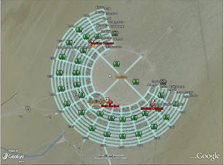
satellite. This annual event, taking place in Nevada’s Black Rock Desert, celebrates both human individuality and togetherness, highlighted by the ritual burning of a large wooden effigy (“The Man”) Saturday evening. You can find the location of the “The Man” in the center of the annually-built tent city, shown below.
Black Rock Desert tent city (left)
Location of “The Man" (right)
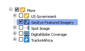
To view this great new Burning Man imagery in
Google Earth
, select the 'GeoEye Featured Imagery' button located in the Google Earth 'More' folder:
Also, if you’re headed out to Burning Man this weekend, be sure to check out this
KML
from
Google Earth Community
user “
Portaplaya
,” which provides a Burning Man street map.
Posted by Pete Giencke, GIS Data Engineer
More easily find some of your favorite businesses right on the map
September 1, 2010
Over the years, we’ve made many improvements to Google Maps to make it as useful and relevant as possible. From basics like road and street names, to labels for points of interest and landmarks, to panoramic images on Street View, we’re working hard to make Google Maps as reflective of the real world as possible.
As part of this effort, we include “places” directly on the map by providing clickable icons that link to the
Place page
for those locations. When you’re on Google Maps on your desktop or on your mobile phone, this makes it easy to explore the world around you and tap into information on the web that can help you make decisions. For example, you can use the map to answer questions like, “Is there a good place to eat near my business meeting?” or “What shops are on that street two blocks over?” In a pilot program in Australia earlier this year, we further expanded this idea of putting places directly on the map by allowing business owners to
brand their locations with their own icons
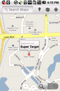
- helping users find familiar brands and helping businesses promote themselves. Interest in this feature has been growing, and today we’re excited to announce the beta of sponsored map icons in the United States.
Now, when you zoom in to areas of interest on Google Maps, you’ll more easily be able to spot the locations of companies and brands that are already familiar to you. That’s because we’re working with business owners to enable them to replace the standard icons that appear on the map at their business locations with their well-known company logos. These logos appear directly on the map when you zoom in to see a close-up view of an area. Just like the existing default business icons that appear in grey, these colored logos are clickable and open the Place page for that business. Both large and small businesses can
claim their Place pages
and enhance them with information including hours of operation, product inventory, photos and videos.
By helping users identify popular businesses, we’re making it easier to browse the map and navigate the real world. That might mean fortunately stumbling upon a nearby ATM when you’re looking up the address of the new restaurant where you’re dining tonight, or exploring the neighborhood you just moved into by figuring out where the grocery store is relative to your new apartment.
In the coming weeks, we’ll also make these sponsored map icons visible on mobile phones, because more often than not, you want to know what’s around you when you’re on the go. So if you’re rushing to meet friends who are impatiently waiting for you “across from the fast food joint,” you can quickly zoom in on the map to see exactly where that is. Or if you’re on the airport shuttle and just remembered you forgot to pack toothpaste, you can keep on time for your flight by checking out Google Maps and discovering that there’s a retail store just a block away from the hotel where you’ll be staying.
In addition to helping you find locations for some of your favorite businesses, these recognizable logos also help business owners promote the storefronts of their well-visited locations. Advertisers pay to have their company logos appear on the map, and to help you remember their locations the next time you’re in the area. Sponsored map icons are being offered as a limited beta to companies in the U.S. with multiple locations and a well-known brand. Participation in this beta does not affect visibility on the map; the new feature is only available to businesses that already appear on the map, and whose default icons can be swapped out for their logo.
Businesses across a variety of industries, from banking to retailers to self-storage, are participating. We hope you enjoy the ease of finding familiar businesses while browsing new, potentially unfamiliar neighborhoods on Google Maps.
Posted by Matthew Leske, Product Manager
Model the world with Google SketchUp 8
September 1, 2010
In the four years that the SketchUp team has been working at Google, we’ve seen an unprecedented collection of user-generated 3D building models spring up all around the world. It is exciting and gratifying to see what you’ve all been able to do with SketchUp, and we’re always looking for ways to make your work more effective.
For all of you who are in on the 3D modeling action, I’m proud to announce the release of Google SketchUp 8 today. We’ve added loads of new features specifically designed to make it easier for you to build Google Earth-ready models of the places that matter to you.
New features in SketchUp 8
include:
Major new features for modeling in geospatial context and for creating new 3D building models for Google Earth.
Model directly from Google’s massive collection of earth imagery, including aerial, oblique and Street View photography in addition to detailed geometric terrain and user generated 3D building models.
Import and improve models created with Google Building Maker
Participate in a community of geo-modelers collaborating on the shared construction of a detailed 3D model of the world.
new “Solid” tools in SketchUp Pro for common additive/subtractive modeling operations
“Outer Shell” to quickly simplify complex models imported from Building Maker
“Union, Subtract, Trim, Intersect and Split” to create complex additive and subtractive form from simple components.
additional features in LayOut for documenting models professionally
Custom line styles
a simple set of dimensioning and annotation tools
native document export to DWG/DXF 2010 format
SketchUp 8 is available today in English, French, Italian, Spanish and German with more languages to be release in the weeks to come. SketchUp Pro costs $495, upgrades from any earlier version are available for $95. And, of course, there is still a powerful version of SketchUp available for free.
Posted by John Bacus, Product Manager
Labels
#streetview
#treasuremap
+1
3D
8bitmaps
Adwords Express
Africa
Amazon
Andorra
Android
api
Art Project
Audi
biking
Boost
Boulder
Brazil
Bulgaria
Business Photos
Business View
businesses
Canada
check-in
community
competition
contest
crisis response
Culture
custom maps
developer
Developers
directions
disaster response
discovery
earth outreach
education
Emmy Awards
Enterprise
Estonia
Europe
Explore
Fusion Tables
gadgets
Gibraltar
GMM
google
Google Earth
Google Earth Engine
Google Map Maker
Google Maps
Google Maps API
Google Maps Engine
Google Maps for Mobile
Google Maps Gallery
Google Maps Navigation
Google Maps Transit
Google Places
Google Plus
Google Search
Google Street View
google.org
Google+
googlenew
Grand Canyon
ground truth
Halloween
historical
history
holiday
Hotpot
Hungary
imager
imagery
Indoor Maps
iOS
iPhone
Iraq
Japan
Latitude
Latvia
layers
LBC
Lithuania
London
Making of Maps
Malaysia
Mall of America
Map Maker
Maps Blog
Maps Gallery
mapsgl
Matt Harding
Mexico
Mobile
Monticello
My Maps
my places
my tracks
National Geographic
navigation
new Google Maps
oblique imagery
ocean
offline maps
Olympics
Outreach
Pakistan
Panoramio
Parks Canada
Pegman
Photo Spheres
photo tours
photos
picasa
Polar Bears
Quiz
real estate
restaurants
road trips
Russia
Santa
Santa Tracker
search stories
SketchUp
Slovakia
Slovenia
South Sudan
space
Spain
sports
Street View
summer
SXSW
Tags
Thomas Jefferson
Thomas Jefferson Foundation
Tip of the week
tips
tour guide
traffic
Train
Transit
travel
trees
Trekker
Trike
Trolley
U.S. National Park Service
Ukraine
University of Virginia
Valentine's Day
Veterans Day
Views
voice search
walking
Waze
weather
webgl
Your Timeline
zagat
Archive
2016
Sep
Aug
Jul
Jun
May
Apr
Mar
Feb
Jan
2015
Dec
Nov
Oct
Sep
Aug
Jul
Jun
May
Apr
Mar
Feb
Jan
2014
Dec
Nov
Oct
Sep
Aug
Jul
Jun
May
Apr
Mar
Feb
Jan
2013
Dec
Nov
Oct
Sep
Aug
Jul
Jun
May
Apr
Mar
Feb
Jan
2012
Dec
Nov
Oct
Sep
Aug
Jul
Jun
May
Apr
Mar
Feb
Jan
2011
Dec
Nov
Oct
Sep
Aug
Jul
Jun
May
Apr
Mar
Feb
Jan
2010
Dec
Nov
Oct
Sep
Aug
Jul
Jun
May
Apr
Mar
Feb
Jan
2009
Dec
Nov
Oct
Sep
Aug
Jul
Jun
May
Apr
Mar
Feb
Jan
2008
Dec
Nov
Oct
Sep
Aug
Jul
Jun
May
Apr
Mar
Feb
Jan
2007
Dec
Nov
Oct
Sep
Aug
Jul
Jun
May
Feed
Google
on
Follow @googlemaps
Follow
Give us feedback in our
Product Forums
.







 Follow
