The last day of March is typically the warmest day of the month. Today, scientists at Climate Central are launching a new interactive Google Map, which allows you to view areas of future freezing in the month of the March in the U.S.

The map shows high-resolution projections for future average March temperatures in the U.S. through the end of the century, focusing on where the average temperature is expected to be above or below freezing. You can use the time controls to scroll through the years, or click "play" to view an animation. You can also compare low vs. high carbon pollution scenarios.


While warm weather lovers may like the idea of warmer Marches, this would mean earlier snowmelt, which has been linked to drier rivers and forests later in the summer, and very much higher wildfire activity in the American West. We could also expect water shortages for farm irrigation and trouble for trout and other cold-water stream life. See how your area will fare by visiting the map now!


Google Maps has allowed you to get public transportation directions in hundreds of cities around the world for a while now, helping you get to your destination without a car. But sometimes you’re not quite sure which destination to choose, and you want to try out multiple options. We often get asked if it will ever be possible to drag your transit route, just like you can do with driving directions. As of today, it is indeed possible! Now you can drag your start or end point to preview your various options for the most efficient itinerary.

Imagine that you are on a business trip to New York City, and you will stay at the Chelsea Hotel. You start planning your trip by searching for directions form JFK airport to the Chelsea Hotel. Then you realize that you can also take a flight to Newark, and you want to figure out which is more convenient for getting to your hotel. Now it’s as easy as picking up the marker at JFK (you’ll see instructions ”Drag to change route” when you hover over the marker):


..and drop it over Newark Airport:


As you drag the marker, we will calculate the new trip automatically in the background and show a tooltip with the time of the new trip. When you drop the marker back onto the map at your desired starting (or ending) point, you’ll see the left panel update with your new step-by-step transit directions. Just search, drag, and ride!


Today the iGoogle team announced a new set of themes designed for the world traveler in all of us. There are 25 themes that highlight places around the world and include beautiful scenery, historic monuments, exotic beaches, iconic cities, and breathtaking sites.

In addition to partnering with National Geographic Society, LIFE, Lonely Planet, UNESCO, and visiteurope.com to bring you the stunning imagery featured in most of the themes, we also created a couple of themes using imagery from Google Earth.

The 3D Views in Google Earth theme gives you a birds-eye view of a couple of natural wonders in the Unites States -- the Grand Canyon and the Great Lakes. It transports you to the last of the remaining Seven Wonders of the Ancient World -- the Great Pyramid of Giza in Egypt. And you can view the stunning architecture of the Taj Mahal in India. Lastly, relax in Positano, Italy, or Bondi Beach, Australia.


The 3D Cities in Google Earth theme puts you in the middle of the action in New York City and Tokyo. It transports you to the ancient ruins of Athens, Greece, and takes you down under to Melbourne, Australia. It also gives you a glimpse into the historic architecture of Budapest, Hungary; Copenhagen, Denmark; and Vienna, Austria.

We hope that you enjoy our new iGoogle themes and that they’ll help inspire you to keep exploring the world around you.


We've just finished pushing out an imagery update for Google Earth and Google Maps, so check to see if any of your favorite places has gotten an update! You can view the updated areas highlighted in red below. Alternatively, you can download this KML for viewing in Google Earth, or you view the updates in Google Maps

We've just finished pushing out an imagery update for Google Earth and Google Maps, so check to see if any of your favorite places has gotten an update! You can view the updated areas highlighted in red below. Alternatively, you can download this KML for viewing in Google Earth, or you view the updates in Google Maps


On March 19, we announced some changes to the Google Earth layers panel intended to make browsing easier (with more descriptive icons, including more than 40 different icons to indicate place types). We also made some changes to the way layers are organized, with the goal of making it easier to find and control our top three layers:

We made the recent changes as part of our continual attempt to streamline and simplify the browsing experience, particularly for casual (or brand new!) Google Earth users. But we know we also have a very loyal community of users who weren’t happy with the changes. One of the most common complaints was that we removed the ability to individually select certain layers (such as “Parks” or “Transportation”), which now appear in our default-on “Places of Interest” layer.

We’ve been listening, and today we released some changes to make these separate layers available again in Google Earth. You can now once again expand the “Labels” folder:

You can also find “Parks and Recreation Areas” under “More,” as well as specific place categories like schools or coffee shops in our new “Place Categories” folder:

Finally, we’re working to restore our separate “Transportation” layers in the near future, and appreciate your patience while we make the required changes.

We'd like to make some further changes in the future to streamline the Ocean, Gallery, and Global Awareness content in our Layers panel, but we realize that many of you have very specific interests and want to easily find the information you care most about. In the interest of making these changes as painless as possible, we invite you to make suggestions about how best to organize the Layers panel in Google Earth.


The US Constitution’s Article I, Section 2 requires a national census every ten years - and the time has come again in 2010. Accordingly, this month the US Census Bureau mailed 120 million forms to households nationwide, and completed forms have begun streaming back. Because this count determines the distribution of more than $400 billion in annual spending and representation in the House of Representatives, local and state governments and media watch mail participation rates very closely (as do many data geeks like myself).

To keep up with all this interest, the Census Bureau is providing daily updates on the participation rate by state, county, and census tract — well over 100,000 distinct geographical entities throughout the 50 states and Puerto Rico. To make this huge amount of data easy to browse, for the first time the Census is plotting it with Google Maps. Check out the Take 10 Map for yourself. What you’ll see is a basic accounting of the percentage of forms that have been received back by region (not by household). None of the results of the survey are shown — that data is not revealed at the household level, and aggregate data won’t be made available for several months.

Additionally, this same data from the Census Bureau is available as a layer for use in Google Earth. You can download the layer for use in your desktop client. You can even embed the layer within your website or share with a friend, just like below. Simply click the “Get Link or Embed” link, tweak the settings to your preferences, and you’ll get the code to send a link or embed in your site -- no permission needed.

In the same spirit as the Take 10 Map and Google Earth layer, we’re also working with the Census Bureau to make their volumes of data more accessible through technologies like Public Data Explorer and the experimental Fusion Tables. If you’re a developer who plots data on maps, we also whipped up some pretty useful border simplifications and regionations for this layer that we plan to make freely available in the near future. And if you’re just interested in looking at pretty maps made with Census data, you’ll definitely want to take a look at some really old ones.

Posted by Jesse Friedman, Product Marketing Manager


Google Maps is often one of the first stops travelers make to find and compare hotels. Today we started experimenting with a new feature, visible to a small portion of users, to help make that process even easier by showing specific prices for selected hotel listings.

With this feature, when you search for hotels on Google Maps you'll be able to enter the dates you plan to stay and see real prices on selected listings. You can click on the price to see a list of advertisers who have provided pricing information for that hotel, indicated by the "Sponsored" text, and click through to reserve a room on the advertiser’s site. By showing you this relevant hotel rate information directly in the Google Maps results panel we hope to make this aspect of your trip planning more speedy and efficient - so you can get where you're going and enjoy your travel destination!

Here's an example of the Google Maps results for someone who is searching for hotels in New York City:


This new feature will not change the way that hotels are ranked in Google Maps. Google Maps ranks business listings based on their relevance to the search terms entered, along with geographic distance (where indicated) and other factors, regardless of whether there is an associated price.

While we're experimenting with this feature, we're currently working with a limited number of advertisers and it will only be visible to a small portion of users . As always, we'll evaluate the usefulness and effectiveness of this new feature based on both data and feedback, and hope to make it available to more users and offer prices from more partners over time.


Last week, we announced several new locations added to Street View, along with existing areas updated. One area updated significantly was the United Kingdom. World renowned for its history, rolling green hills and quaint picturesque villages, the UK (although not abundant with dramatic mountainous scenery one see may elsewhere), there are nonetheless many different sights to see. As a UK citizen, I thoroughly enjoyed exploring my home country and want to share with you some places outside the usual tourist belt... and of course some quirky scenes too!

Firstly, going all the way back to the year AD 122, Hadrian's wall is a UNESCO World Heritage Site built by the Roman empire. Parts of the wall are still intact, and each year thousands of people flock to walk sections of the route. Now, you can too without having to worry about getting wet (the UK is famous for its rain for a reason, after all):


View Larger Map

Synonymous with many great examples of English literature, particularly poetry, the Lake District is a showcase of English countryside. Green pastures rise high to form beautifully sculptured valleys with lakes nestling in between. It's easy to see how poets such as William Wordsworth felt inspired when surrounded by scenes like this:


View Larger Map

One form of building construction I am particularly fond of, used in many parts of the UK, is 'thatching'. Using different grasses, primarily straw, these roofs create very attractive buildings and often form the basis of the 'picture postcard' views in areas such as in the Cotswolds. This view below from the Isle of Wight is a classic example of thatching in use to make this quaint English villages scene.


View Larger Map

In 2008, the city of Liverpool was joint holder of the European Capital of Culture. Well known as the birth place of the Beatles, Liverpool is currently undergoing significant regeneration. Outside China, Liverpool is home to one of the largest and oldest Chinese communities, and this image below shows the entrance to Chinatown:


View Larger Map

Belfast, the capital city of Northern Ireland has a long and fascinating history. In recent years, the city has enjoyed much growth and continues to be a popular tourist destination. If it's not up next on your own travel agenda, you can tour through Street View. I suggest visiting Belfast City Hall -- built over a century ago, the hall now stands out as an excellent example of Baroque revival architecture.


View Larger Map

One of the most distinguished cities in the UK and known for its very distinctive architecture, Bath was added to the list of World Heritage Sites in the late 1980s. Established as a spa town by the Romans, Bath is visited each year by millions of people eager to capture the image of rows of houses built from the aptly named Bath Stone:

View Larger Map

Along with these historic and picturesque settings that you'd probably expect from the UK, there are also plenty of amusing things to find through Street View. If you're a fan of long, funny words (like I happen to be), you must visit Llanfairpwllgwyngyllgogerychwyrndrobwllllantysiliogogogoch in Wales, with one of the world's longest placenames. Here the image shows the place name written on a business in the town centre.

View Larger Map

You may not expect our Street View drivers to also serve occasionally as wildlife photographers, but that seems to be what happened with this "Bird View":

View Larger Map

And sometimes we stumble across things that we just can't explain:

View Larger Map

Now if that small selection of oddities has your brain considering what else might be lurking out there, perhaps it's time to visit Loch Ness. With Urquhart Castle in the foreground, maybe Nessie is out there somewhere. You be the judge:

View Larger Map

I hope you have enjoyed my guided Street View tour of the United Kingdom. I wonder what else you can find?


Google Earth is a great way to take a quick tour around your neighborhood or fly to your next holiday destination. Infomation about hotels, parks, mountains and other interesting places is available at your fingertips. You can check out the nearest bus or train station for a spontaneous trip or click on a city name to learn more about it from your desk chair.

Since there’s so much rich content in Earth, we know that it can sometimes be challenging to find what you’re looking for. That's why we've made some minor changes that will make it easier to browse for places and content.

We’ve regrouped and simplified some of the content in the Layers panel to make it easier to use. You can still find the same photos, places of interest, parks, and transit stations as before -- just organized a little differently.


We’ve also added descriptive new icons to help you identify places of interest as you browse the globe:


Another way to explore lots of great content provided by Google Earth users is with the Google Earth Gallery. Here you’ll find 3D tours like U.S. College Basketball Arenas or Vancouver Olympics venues, or a map of real-time Earthquakes. If you have your own great content you want to share with others, you can submit your KML to the Earth Gallery.


We hope these changes to Google Earth help you explore your world more easily and learn about some new places you’ve never seen before.


Do you feel it, sports fans? Has the anticipation fully gripped your college basketball soul? It's definitely got my attention. Therefore I've embarked on my third consecutive journey into mapping the NCAA College Basketball tournament. This may have caused a bit of personal March madness - a lot of long nights and triple-checking each arena placemark - but I hope you’ll enjoy the result. I’ve made a Google Earth KMZ file that includes the home arenas of the field of 65, and the 14 tournament venues. Each entry in the field of 65 is color coded by region and the game sites have a special basketball icon this year.

You may wonder why I’ve kept this up for three years. Well, aside from the fundamental fact that I'm a college hoops nut, I just so happen to also love seeing the geo-spatial distribution of the teams. The research and compliation of the information led me to several interesting facts you can see for yourself in the layer and then use to wow your friends, such as:
  • There are two first-round matchups that pit two teams which have the same mascots
  • Bears, Eagles, Gophers, Grizzlies, and Lions have a common trait: they are all 'Golden'
  • This year’s tournament is quite colorful: Blue Devils, Mean Green, Orangemen, Big Red, and Yellow Jackets
This My Map also shows you all the key locations for the Madness, color-coded for your viewing pleasure. The East division is indicated by a blue pin; South with green; Midwest with red; and West with cyan. The pins with a dot in the center tell you who the #1 seeds are:

Travel to the tournament without leaving home! All 14 arenas are in the “3D Buildings” layer in Google Earth, ready for you to explore. Take a tour of these 3D models by watching the video below or download this kml tour and open it in Google Earth 5. Be sure to check out the Energy Solutions Arena in Salt Lake City -- even the court is modeled.


Also, teaming up with a few other March Madness enthusiasts, we’ve created a page, google.com/collegebasketball2010, where all of you basketball fans can find additional Google tools to help you track the tournament. Keep up with your favorite teams and get up-to-date information on scores, schedules, and brackets with our iGoogle gadget. By doing a quick search for your favorite team, you can see live scores. If you haven’t already made a bracket, check out our Google docs tournament bracket template to help you create and manage your pool in an online spreadsheet. You can also see real time search results so you never miss any March Madness news or chatter!

For all the times when I can’t be planted in front of my television watching the action (or during those pesky commercial breaks), these tools will keep my head in the game!

[Cross-posted from the Google Mobile Blog]
[Cross-posted from the Google Mobile Blog]

Making sense of a fast paced and changing world is difficult under the best of circumstances, but when you’re on the go, it’s even harder. With the new Google Maps for mobile 4.1, we’re introducing a few features that make sorting through search results or quickly seeing Maps info a bit easier.

Updated search results page
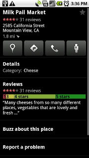
With the newly reimagined Google Maps for mobile search results page, we’ve done away with the tabs to give you all the info you want on one page. Tap the new buttons to see the place on the map, get directions, call it, or see it with Street View. The extra space let us bring details and reviews right up front.

Swipe for more results
Take a look at the new page, and you can quickly see that Milk Pail Market specializes in cheese, has mostly 4 and 5 star ratings, and also sells fresh vegetables. You can select any section to see more reviews, buzz, etc. If you want to get to more search results without going back to the list, simply grab the page with your finger and swipe it away to the left or right to see the next or last result.
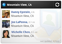
Latitude widget and Maps live wallpaper
Once you’ve updated to Maps 4.1, you’ll also have a couple different ways to put Maps up close and personal on your phone. Wouldn’t it be nice if you could quickly find your nearest friends or glance at the traffic conditions around you without opening Maps? Add the Latitude widget to a home screen panel to see your nearest Latitude friends by pressing the “Menu” button from the home screen
and selecting Add > Widgets > Latitude. On Android 2.1+ phones, you can also turn your home screen into one big, updating map using the Maps live wallpaper. Press the “Menu” button from your home screen and select Wallpaper > Live wallpapers > Maps. Now you can see nearby friends or a map each time you open your home screen.


Switch Google Accounts
We’ve been adding more and more features that sync with your Google Account whether you’re on your phone or your computer. If you’re managing multiple identities, Maps now lets you switch the Google Account it uses between the accounts you’ve synced to your Android-powered phone. From the Maps menu, select More > Switch Account to sign out of your current account and sign in to a different one. Features like Google Buzz, Latitude, Starred items, My Maps, and more can then begin using whichever account you’ve chosen.

Get these new features at your fingertips by searching for “Google Maps” in Android Market from Android 1.6+ phones. Update Maps to version 4.1, available in all the countries and languages where Maps is currently available. Visit our Help Center to learn more, ask questions in our Help Forum, or give us suggestions and vote on other people’s on the Mobile Product Ideas page.


Along with many other Googlers, the Geo team is descending upon Austin for South by Southwest! You can find us in a few different places:
  • At the Google booth, we’ll be doing demos of Google Maps, as well as plenty of other Google products.
  • In the Google Teaching Theater, you can meet engineers who built biking directions and hear all about how it was created (see the schedule here).
  • On Saturday, we’ll be hopping on our bikes to take part in Bike Hugger’s Mobile Social. Along the way we’ll be handing out some fun bike-related schwag, dishing more about how we built biking directions, and getting feedback directly from the cyclists.
For those who aren’t able to make it to SXSW, remember to check out our contest to win a new custom bike: simply tweet with the hashtag #bikewithgoogle -- maybe share your favorite trail or a new route you want to try taking to the office -- and you’ll be entered to win!

You can read more about all of the Google happenings on our SXSW website, and follow @googlesxsw on Twitter for last-minute updates and news from Austin. We can’t wait to hit the ground running (or biking), and we look forward to seeing you there!


Today, Barcelona joins its Spanish neighbors Madrid and Valencia as 3D cities in Google Earth. If you’re a fan of architecture, Barcelona offers a visual feast. The mix of old and new is truly facinating. It contains architectural wonders that date back to medieval times, in addition to modern architecture designed by critically acclaimed architects.


Open Google Earth and fly down to Barcelona to see hundreds of 3D models of buildings, monuments, cathedrals, museums, statues, towers and much more. If time was short, my guided tour would probably start at what is arguably the most famous building in the city, the Sagrada Familia. Staying with the cathedral theme I’d head over to the Barcelona Cathedral located in the center of the city. The Casa Milà would be next on my list; this amazing work of art was designated a World Heritage site in 1984.

If modern architecture is more to your liking, you’ll want to visit the Montjuic Communications Tower and the Torre Agbar (which shouldn’t be too hard to find given its unique shape). I could go on, but since a picture is worth a thousand words, we’ve created a short video (above) that showcases many of Barcelona’s most popular destinations. Judging by the thousands of models that users have created using Google SketchUp and Building Maker, I think it’s pretty evident that I’m not the only admirer of this wonderful city.


Hong Kong and Macau have now joined the list of places you can visit with Street View. If peering up at dense, towering skyscrapers is your thing, you won’t want to miss Hong Kong, home to more than 7,000 of them. Take a look at this view of the Hong Kong Island skyline, looking across from Kowloon:

View Larger Map

Or you can look down on the bustling city streets from the verdant hills of Tai Mo Shan park:

View Larger Map

This view of the Macau Tower from the Sai Van Bridge shows you two more of the architectural landmarks of Macau:

View Larger Map

Today’s Street View update isn’t just about what’s new -- you can also visit the past. You can view new World Heritage sites, as well as locations from your own personal heritage.

Our trike recently visited the beautiful historic city of Kyoto, where you can now view two of Japan’s UNESCO World Heritage locations, Nijo Castle and Nishi Hongwanji Temple:

View Larger Map
Nijo Castle


View Larger Map

Nishi Hongwanji

Ten other special sites around Kyoto have been added to Street View, including 2 universities and many more temples.

On the other side of the globe, you can now explore Street View panoramas all around the UK, from Wales to across the sea in Northern Ireland, and a great many places in between. This inspired a train conductor from South London to explore his past through our imagery, posting links to Street View of memorable places from throughout his life on his Twitter account. He took his friends on a virtual trip down memory lane, showing where he went to university and where he worked during school holidays all the way through the train station where he’s currently based. And in Australia, the “mum” of one of my teammates has been browsing through the new UK images to find the small town where her ancestors came from: she knew the town they lived in and the former name of the building where they lived, but had no idea how to find it today and after spending some time clicking through Street View in the town, she found an old sign on a wall with the former name of the building -- exactly where her family lived more than a century ago!

Whether it’s to find new and exciting corners of the globe, or to explore places of personal significance, enjoy traveling through these new additions to Street View.


Over on the Official Google Blog, you can read a very, very exciting announcement: Google Maps now offers biking directions! As my teammate Shannon mentions in that post, we've been constantly asked when this feature will be made available. But as an engineer working on the directions team, I'd often get questions about why Google Maps didn't already have biking directions. After all, we've had driving, walking, and public transit directions for some time, so what is it about biking directions in particular that presents an engineering challenge?

Well now that the good news is out, I can lift the curtain and explain the many factors and variables that we've had to take into account to put this whole feature together:
  • Bike trails: Our maps contain over twelve thousand of miles of biking trails. First, we had to figure out where trails are, so we worked with the Rails-to-Trails Conservancy to get much of our trail data. Once we had trails mapped out, the next task was to incorporate them into our routing algorithm. The algorithm is weighted to strongly prefer routing on these trails rather than roads open to automobile traffic, so your directions will try to put you onto a trail as long as it won't take you totally out of your way. On our bicycling layer (found under the 'More' button), these trails show up in dark green.
  • Bike lanes: For more than 150 cities in the US, we know which streets have dedicated bicycle lanes. These are also prioritized when coming up with a routing suggestion. On the bicycling layer, you’ll see these roads indicated in bright green.
  • Recommended routes: For many cities we also provide information on streets that have been designated as good for cyclists, so we them into account in our algorithm. These roads are indicated with dashed green lines on our bicycling layer.
  • Uphill slopes: l don't know anyone who enjoys biking up a hill, especially when you're trying to get somewhere you need to be. Going uphill is worse than simply being much slower; it's also exhausting and can take a toll on the rest of your ride. Our biking directions are based on a physical model of the amount of power your body has to exert given the slope of the road you’re biking on. Assuming typical values for mass and for wind resistance, we compute the effort you’ll require and the speed you’ll achieve while going uphill. We take this speed into account when determining the time estimate for your journey, and we also try hard to avoid routes that will require an unreasonable degree of exertion. Sometimes the model will determine that it's far more efficient to make you ride several extra blocks than to have to deal with a massive hill. My teammates in San Francisco were relieved to see that this does indeed work!
  • Downhill slopes: Many cyclists will tell you that going downhill is annoying for a different reason: you may have to ride your brakes all the way down. All else equal, we try to avoid routes that require a lot of braking. Of course, in some cities, including my hometown of Seattle, this isn’t always possible! And if you feel like you need a big workout and want to climb some hills, or if you just love that wind-in-your-hair feeling of a long downhill (you better be wearing a helmet and staying safe!), you can always turn on the terrain layer to check out the hilliness of an area for yourself.
  • Busy roads: Cyclists often tend to prefer to stay off of fast roads, and not even cross them unless it's necessary. This is roughly the inverse of driving directions, where you want to stay on arterials and freeways, so we had to rework a lot of those fundamental calculations when coming up with our biking directions algorithm.
  • Busy intersections: We try to avoid making you cross busy streets with a lot of car traffic and long wait times.
Even having figured out how to account for all these variables and cost-estimates in our algorithm, the biking direction feature would not have been possible without our new base map data which allowed us the flexibility to easily incorporate bike trail data, a fundamental part of this feature. It also allowed us to readily incorporate feedback directly from our users, and we welcome all your feedback and suggestions via the "Report a problem" tool -- after all, biking directions are still in beta and we're continuing to work on adding more data about bike trails, bike lanes, and preferred roads. Both of these updates were made in October, at which time we promised that that biking directions were in the works, and now five months later: here they are!


Last week we announced that you can edit details about a business listing directly through the Place Page. But sometimes you may find a place in Google Maps that isn't quite positioned where it should be. Let's say you know that your favorite pizzeria is near the corner but the marker for it appears further down the block. You want all hungry pizza-cravers to be able to find this great spot, so you want to make sure the marker leads them directly to the storefront. You could use our map editing feature (the "move marker" edit) to move it to the right place, but moving the marker to the right location is not always that easy, especially in denser urban areas, if the only reference you have are maps or satellite images because you can only get a view from above. So now we have added one more very handy reference for making a map marker edit: Street View images. It makes the edit much easier.

Let me show you how the editing feature works.

When you find a place that is in a wrong location, click on the marker and get an infowindow open as what you did before.


Click on the "more" link, and then click the "Move marker" link in the drop down menu. You'll see two jumping markers in the map and the Street View image appear, which means both of them can be dragged. When you drag the marker on the map to a new position, the marker inside the panorama will be updated correspondingly, and vice versa.


Since you can now view a street-level image of where the marker will be placed, it's not difficult to find the exact spot in the image and place the marker to the right position. Isn't that convenient? After editing, all you need to do is to click the "Save" button above the Street View panorama. If you're not happy with the edit, or just not sure if it is correct, you can always hit the "Cancel" button. Edits with Street View images tend to be more accurate and precise because looking at the ground-level images provides very helpful local detail.

With the editing feature, we encourage our users to put the marker at the entrance of the place. However, users sometimes put the marker in the center of a street block, and we don't have an easy way of detecting this. By introducing this feature, we know approximately where the facades are from Street View images. Based on the information, we can snap the dragged markers to the closest facades automatically by using street view information. Of course, we have a threshold for the snapping: if you attempt to put a marker inside a large place with no Street View image (for example, a park or a stadium), we may end up with the marker in the center and a message box indicating there isn't a Street View image available.

Now you can make sure that everyone searching for your favorite businesses in your hometown can be directed to exactly the right spot, so do your part and move those markers.


We've just finished pushing out an imagery update for Google Earth and Google Maps, so check to see if any of your favorite places has gotten an update! You can view the updated areas highlighted in red below. Alternatively, you can download this KML, for viewing in Google Earth or you view the updates in Google Maps.


We've just finished pushing out an imagery update for Google Earth and Google Maps, so check to see if any of your favorite places has gotten an update! You can view the updated areas highlighted in red below. Alternatively, you can download this KML, for viewing in Google Earth or you view the updates in Google Maps.


Back in 2008, we started opening Google Maps up to user edits. With the launch of Place Pages in September, we decided it'd be a lot easier if editing had its own page too. Today, we're pleased to announce a new, easier way to edit places on Google Maps.
If you find something incorrect or missing on the Place Page for a business -- maybe they have a new website or moved to a bigger location down the block -- just click "Edit this place":


You'll then access a single, dedicated page where you can edit the business listing details about that place.

If you happen to stumble across a problem that you don't know how to fix, no worries. You can always report a problem directly to Google instead of attempting to edit it yourself. Just look for the Report a problem link in the "more" menu and tell us what's wrong, then we'll take on the job of tracking down the right information. Also, if you're the owner of the business, you can click the "Business owner?" link to supply additional information and see your dashboard.

We realize that you know your own neighborhood best, so we hope this makes it simpler and more streamlined for you to pass that local knowledge along to all your fellow Google Maps searchers.


Have you ever dreamed of being a marine scientist? With today's release of a Google Earth tour by the Pew Environment Group to introduce the 2010 Pew Fellows in Marine Conservation, you can put on your virtual scuba gear and join them in the underwater ecosystems, coral reefs, and shores around the world.

Narrated by actress and philanthropist Isabella Rossellini, the Google Earth tour introduces you to the work of the new Pew Marine Fellows: Daniel J. Conley, Omar Defeo, Beth Fulton, Peter Mumby, and Ben Sullivan.


The prestigious fellowship is awarded each year to five outstanding global leaders or teams for working tirelessly to preserve and protect the world’s oceans and marine species. For the next three years, these marine scientists will work on their original, research-based marine conservation project.


Each Pew Marine Fellow will communicate his or her results widely, so check back for more information about the program and the fellows at www.pewmarinefellows.org, or you can learn more about the fellows now by viewing the Google Earth tour on the 2010 Pew Marine Fellows website today!